|
|
Post by cuttydyer on Aug 29, 2013 10:34:26 GMT
|
|
|
|
Post by sigurdur on Aug 29, 2013 13:35:53 GMT
Well, it is looking more and more like we will have a winter similar to the later 70's in the NH. Funny how everyone has gotten used to warmer temps and seem to like them.
|
|
|
|
Post by glennkoks on Aug 29, 2013 14:54:45 GMT
sigurdur,
I am not sure I agree with your NH forecast. If the pattern we have seen over the last few years continues and the progression of Rossby Waves stays more latitudinal we will probably see both record warmth and frigid cold depending on where you are at. If this summers pattern in the U.S. continues and the trough remains over the eastern half of the nation it will be a nasty winter indeed. But the Western half could be very mild.
It will be interesting to see if the cooler arctic summer equates to a colder NH winter.
|
|
|
|
Post by nonentropic on Aug 29, 2013 19:03:53 GMT
so the question is will the loss over power the wins.
The waves rotate slowly is anyone able to predict the rate and hence the location several months out. A Rossby forecast or a blocking high prediction for the next season. is there one?
for Sig it may be an opportunity being prepared.
|
|
|
|
Post by cuttydyer on Aug 30, 2013 8:39:08 GMT
|
|
|
|
Post by cuttydyer on Sept 2, 2013 7:50:39 GMT
|
|
|
|
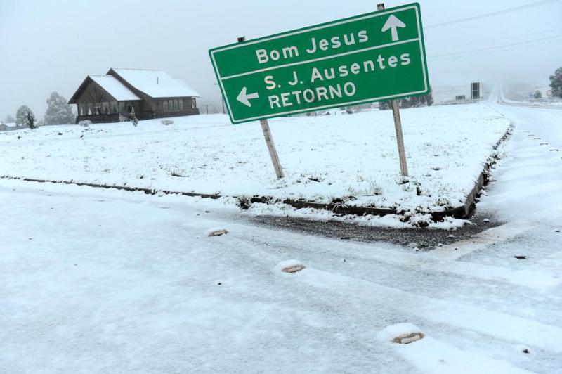
Post by cuttydyer on Sept 2, 2013 7:56:20 GMT
BBC reports: Peru snow state of emergency extended to more regions  The Peruvian government has extended to nine more regions a state of emergency called to cope with unusually cold weather and heavy snowfall. At least two people have died and 33,000 others have been affected by the cold spell, local officials say. Tens of thousands of animals have frozen to death over the past week. President Ollanta Humala has travelled to Apurimac, one of the worst-hit areas, to oversee the distribution of emergency aid. The state of emergency would be in place for 20 days, an official statement said. The heaviest snow fall to hit Peru in a decade has killed tens of thousands of llamas, alpacas, cattle and sheep, and left farmers destitute. Link: www.bbc.co.uk/news/world-latin-america-23916217 |
|
|
|
Post by sigurdur on Sept 2, 2013 8:14:29 GMT
Not good
|
|
|
|
Post by graywolf on Sept 2, 2013 11:02:57 GMT
I'd agree that 2012 sea ice low did indeed force a phase shift in the polar Jet. The amplification appears to remain as high as we have become used to but the 'troughs and ridges' of the Jet appear 'shunted'. We see the UK finally free of it's post 07' summer blight and the US now under trough and ridge ( and not just ridge ) with Greenland also being spared the HP that had become so common on it's southern half ( limiting the kinda melt we saw in 2012?).
The question , for me at least, is how this years ice/snow levels will impact the jet? Will it relax back into the post 07' configuration or is the 'new' pattern set until the next 20% drop in sea ice levels delivers enough of a jolt to 'shunt' the pattern again?
Should it remain as is then the UK can expect a mild winter with a couple of wind storms and a couple of notable snow events ( no prolonged cold episode late in the winter season).
The difference across the N.Hemisphere has been most notable across the Arctic.....compare average slp from last summer to this summer and you'll see the magnitude of the change!).
Sadly the inner continental highs, being self fuelling, have been as they ever were with record drought/heat/wildfire outbreaks and Siberia again suffering all the above ( continuing the permafrost meltdown there and adding to the woes with more 'black earth' from rampant wildfires awaiting next summers warmth.
|
|
|
|
Post by nautonnier on Sept 2, 2013 11:51:18 GMT
I'd agree that 2012 sea ice low did indeed force a phase shift in the polar Jet. The amplification appears to remain as high as we have become used to but the 'troughs and ridges' of the Jet appear 'shunted'. We see the UK finally free of it's post 07' summer blight and the US now under trough and ridge ( and not just ridge ) with Greenland also being spared the HP that had become so common on it's southern half ( limiting the kinda melt we saw in 2012?). The question , for me at least, is how this years ice/snow levels will impact the jet? Will it relax back into the post 07' configuration or is the 'new' pattern set until the next 20% drop in sea ice levels delivers enough of a jolt to 'shunt' the pattern again?Should it remain as is then the UK can expect a mild winter with a couple of wind storms and a couple of notable snow events ( no prolonged cold episode late in the winter season). The difference across the N.Hemisphere has been most notable across the Arctic.....compare average slp from last summer to this summer and you'll see the magnitude of the change!). Sadly the inner continental highs, being self fuelling, have been as they ever were with record drought/heat/wildfire outbreaks and Siberia again suffering all the above ( continuing the permafrost meltdown there and adding to the woes with more 'black earth' from rampant wildfires awaiting next summers warmth. Your causal relationship is the wrong way around. The jet streams have become more meridonal due to the drop in UV causing a drop in ozone and possibly the drying of the stratosphere. The convection at the equator is also weaker. This has led to reduced Hadley cells and a drop in the altitude of the TOA. The more meridonal jets lead to more cloudiness over the oceans and therefore cooling this has and will continue to increase the amounts of snow and ice. |
|
|
|
Post by trbixler on Sept 3, 2013 0:57:25 GMT
"Deep Cold: Interior and Northern Alaska Weather & Climate" 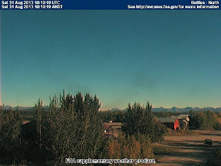 "A cold airmass and clear skies allowed for temperatures to plunge to record low levels in the northern Interior. Most notably, Bettles recorded a low of 15ºF Saturday morning. This is by far the lowest temperature of record at Bettles in August. The previous record at the Bettles in August was 22ºF on August 30, 1969. At old Bettles, about four miles downriver from the current townsite, a low of 20ºF was measured on August 24, 1948. Other low temperatures included 17ºF at both Chandalar DOT and Coldfoot DOT and a chilly 13F at the Norutak Lake RAWS west of Bettles. These are close to, but not at the record low temperature for the month of August in the state" link |
|
|
|
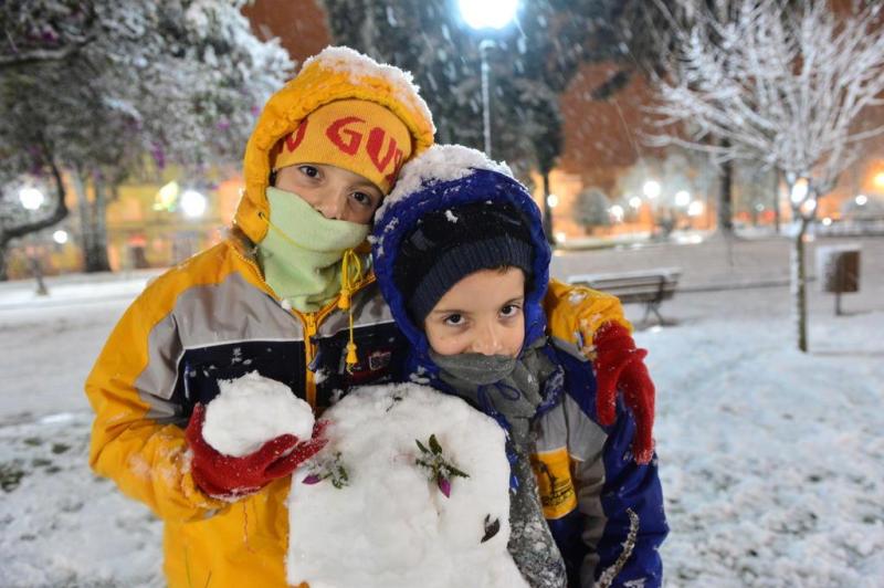
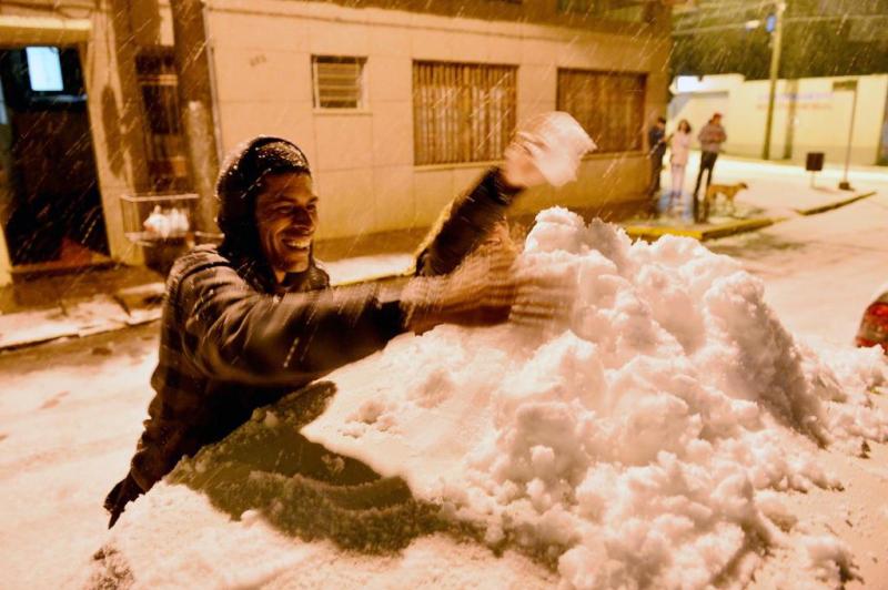
Post by cuttydyer on Sept 3, 2013 9:54:46 GMT
Video about the emergency in Puno, Peru - graphically highlights the misery of a cold winter.
|
|
|
|
Post by graywolf on Sept 3, 2013 10:41:37 GMT
|
|
|
|
Post by cuttydyer on Sept 3, 2013 10:56:06 GMT
So the Guardian haven't bothered to cover the potential humanitarian catastrophe unfolding in South America - I wonder why that could be... I note that in the Guardian article, the winter weather didn't prove a problem for New Zealand's skiers. "Annah Dowsett, a spokeswoman for the Whakapapa and Turoa ski fields on Mount Ruapehu, said dumps of snow early in the ski season followed by weeks of pleasant weather provided the perfect conditions" |
|
|
|
Post by Andrew on Sept 3, 2013 11:03:02 GMT
I doubt if Antarctica is having its warmest year and i suspect talk of New Zealands snow was from last year as i dont recall any such talk this year. Perhaps next year you will have more luck with crackabollockopolis? |
|