|
|
Post by nautonnier on Oct 16, 2013 15:57:17 GMT
I can see this winter as being continued yin and yang. Brutally cold in the troughs and unseasonably mild in the ridges. Storminess in-between. Brought to you by a loopy longitudinal jet stream that seems to be more in vogue of late. It will be interesting to see if a colder arctic summer with more ice translates into a colder NH winter. I think problems may occur if there are blocking highs and the loops stay in place with the continents getting the polar air. The Brazilian met people are forecasting that Chicago will go below freezing this month and may not go significantly above until March. (Not sure how I can get the reference on here from Weather bell) |
|
|
|
Post by flearider on Oct 17, 2013 0:43:49 GMT
i'm thinking the jet stream will start to even out but stay low. nature has a way of returning balance but with a cooler sun the jet an't going to move up for a while ..
|
|
|
|
Post by sigurdur on Oct 17, 2013 2:26:43 GMT
i'm thinking the jet stream will start to even out but stay low. nature has a way of returning balance but with a cooler sun the jet an't going to move up for a while .. Not only the cooler sun Flearider, but the UV rays effect on the Strat, which truly places the Jets. |
|
|
|
Post by nautonnier on Oct 17, 2013 7:42:00 GMT
i'm thinking the jet stream will start to even out but stay low. nature has a way of returning balance but with a cooler sun the jet an't going to move up for a while .. Rossby waves will form in the slower moving jets leading to meridonal flow this will increase cloudiness and if the jets run up over the Himalayas will lead to monsoons and Sudden Stratospheric Warming events. When blocking 'omega highs' form in the poleward loops the weather can lock in for weeks/months. If the cold that is dropping down behind the current meridonal wave in the jet across the USA were to lock in now for 8 weeks as some models are forecasting then it will get decidedly chilly the blocking Greenland high could cause a similar cold loop to form down over western Europe - perhaps this should be in the how do iceages start thread  |
|
|
|
Post by karlox on Oct 17, 2013 8:10:35 GMT
Strongest Blocking High in NH is currently in North America Pacific, North-west. Forecasted to persist well into next week... Looks like a lot of cold air might be even reaching as far south as the Gulf shoreline? In the animation below you can also see typhon approaching Japan, and Spain slowly getting into the wet-warm side of the wave with prevailing humid-westerly winds. That´s expected automn weather for us! (As for Spain: persistent droughts suffered in large areas for many years of late 20th century and some of the present are well gone; and that´s very good for all of us) NH polar view of Surface and 500mb forecast Oct 19-22[/a]e |
|
|
|
Post by glennkoks on Oct 17, 2013 13:33:33 GMT
It seems like the Greenland high tends to block the colder air on the east coast of the U.S. leading to colder weather. The backside or PNW tends to stay warmer. If that is the pattern this winter it may mean it's going to be a rough road to hoe east of the Rockies. One would think this pattern is amplified when the AMO is in a negative phase when SST's are lower. Perhaps the negative phase of the AMO is more conducive to blocking "omega highs" and this pattern is going to become more of a "norm" as the AMO flips?
One thing is for sure, the arctic summer was certainly not what we have become accustomed to over the last several decades or so. Change is in the air.
|
|
|
|
Post by cuttydyer on Oct 17, 2013 15:14:56 GMT
|
|
|
|
Post by sigurdur on Oct 17, 2013 20:03:55 GMT
Code: It flipped. Kinda like watching the meandering 6-10 for my area. One day it was for WAY above average temps, next day below, next day above.....it changed every day.
Back to the old adage that anything longer than 12 hr forecast is a crap shoot at best.
|
|
|
|
Post by throttleup on Oct 18, 2013 0:00:00 GMT
Cutty (or anyone),
Does anyone know the AMO index for Sep? Can't find it with my usual sources probably due to gov't shutdown.
|
|
|
|
Post by nautonnier on Oct 18, 2013 6:28:41 GMT
Cutty (or anyone),
Does anyone know the AMO index for Sep? Can't find it with my usual sources probably due to gov't shutdown.
Is this it? |
|
|
|
Post by cuttydyer on Oct 18, 2013 9:18:11 GMT
Dr Roy Spencer blogs: The Polar Express is Leaving the Station 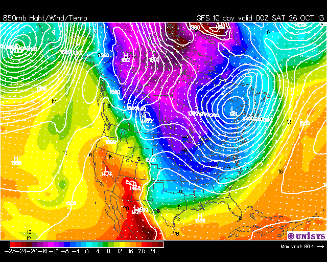 I’ve been watching the 10-day GFS forecast for the U.S., and each run is reinforcing the previous one, with a major cold air outbreak for most of the U.S. late next week. I’m reminded of when I started the graduate program in meteorology at UW-Madison in the fall of 1978. We were getting an unusual string of cold fronts which all the professors were claiming could not last. Eventually, warmer Pacific air would come in from the west…it always does. Except during winter ’78-’79…it didn’t. The cold air just kept coming. Rest of post: www.drroyspencer.com/2013/10/the-polar-express-is-leaving-the-station/ |
|
|
|
Post by nautonnier on Oct 18, 2013 11:04:14 GMT
Cutty, The main reason for the outbreak of cold is the algor effect of Al Gore hosting another "Climate Reality Project" 24 hour show in DC 22-23 October. As you know all such events and IPCC meetings seem to be accompanied by inclement weather  More worryingly read the comments on Roy Spencer's post you linked to. Harold Ambler saying 'Don't Sell Your Coat' looks like wise advice. I am in central Florida and it is already cooler than normal with cold fronts running through most of this year which normally only starts at the end of 'Hurricane (sic) season' in November. |
|
|
|
Post by cuttydyer on Oct 18, 2013 11:44:57 GMT
Cutty, The main reason for the outbreak of cold is the algor effect of Al Gore hosting another "Climate Reality Project" 24 hour show in DC 22-23 October. As you know all such events and IPCC meetings seem to be accompanied by inclement weather More worryingly read the comments on Roy Spencer's post you linked to. Harold Ambler saying 'Don't Sell Your Coat' looks like wise advice. I am in central Florida and it is already cooler than normal with cold fronts running through most of this year which normally only starts at the end of 'Hurricane (sic) season' in November. I'm taking the potential threat of an extreme and harsh UK Winter very seriously. It just happens that all the notable/memorable Winters on Dartmoor coincide with slumps in solar activity:  Link for full size image Link for full size imageAP graph link: www.leif.org/research/Ap-1844-now.xlsMET CET data link: www.metoffice.gov.uk/hadobs/hadcet/data/download.htmlI've recently discovered this account of the West Country blizzard that occurred in March 1891(another low solar coinciding event): Title: The Blizzard in the West Being as Record and Story of the Disastrous Storm which Raged Throughout Devon and Cornwall, and West Somerset, On the Night of March 9th, 1891 The account opens with: "On the morning of the 9th of March, 1891, when inhabitants of the three westernmost counties in England set about preparing for the routine duties of daily life, nothing seemed to indicate that, with the approach of nightfall, the gravest atmospheric disturbance of the century—in that part of the world, at all events—would come to spread terror and destruction throughout town and country. " 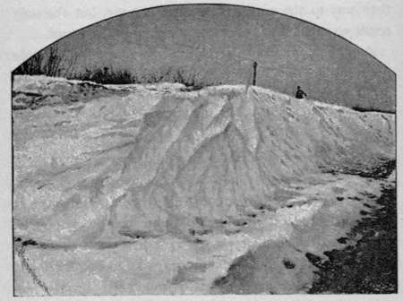 SNOW DRIFT, ROBOROUGH DOWN, DARTMOOR. 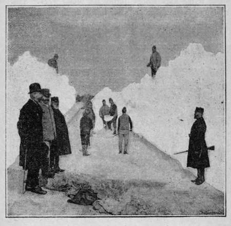 CONVICTS CUTTING A ROAD AT PRINCETOWN, DARTMOOR. Link: www.gutenberg.org/files/43758/43758-h/43758-h.htmThis March blizzard resulted considerable losses of Dartmoor livestock, only 10 years earlier the infamous Winter of 1881 had also resulted in enormous losses of sheep, ponies and cattle.  |
|
|
|
Post by trbixler on Oct 18, 2013 12:39:31 GMT
cutty
Day by day Dr. Soon looks all too right.
|
|
|
|
Post by nautonnier on Oct 18, 2013 12:53:19 GMT
So Cutty - how would Ed Davey survive a severe winter and power cuts? Seems he's an awful long way out on the plank.
|
|


