|
|
Post by sigurdur on Feb 8, 2014 14:18:43 GMT
I don't see how an El Nino is going to be generated either.
Yes, past history indicates there should be one, but most of past history is with a warm PDO as Naut explained.
Just like that pool of warm water off Alaska. This seems to happen during a cold PDO, which then affects the American Southwest precip patterns, and Upper Mid West/East coast temp patterns.
|
|
ant42
Level 3 Rank
 Melbourne, Australia
Posts: 129
|
Post by ant42 on Feb 9, 2014 12:20:35 GMT
Agree with that. However, we are having a re run of 2009, a searing record heat summer, though not quite as high as those temps.
But very much the same. What followed was very unusual.
Late in 2009 when the El nino started to come on it went incredibly humid and wet through November.
This continued through 2010 so by the time La Nina started coming on in Sept 2010 we were already getting flooding rains due to the negative IOD that occurred in the winter and spring.
Normally of course it would be droughts during and El nino for Eastern OZ but it was almost polar opposite. Also, this heat this summer was not the dry heat of 2009 with dewpoints in the negatives, they have been in the low teens instead.
Most unusual. We will now need to see negative dailys in the SOI which will precede a westerly wind burst. That should get the Kelvin Wave moving East. However I still think it could be (a) too early and (b) wash out as it surfaces ala 2012.
|
|
|
|
Post by graywolf on Feb 9, 2014 14:41:00 GMT
Both  and 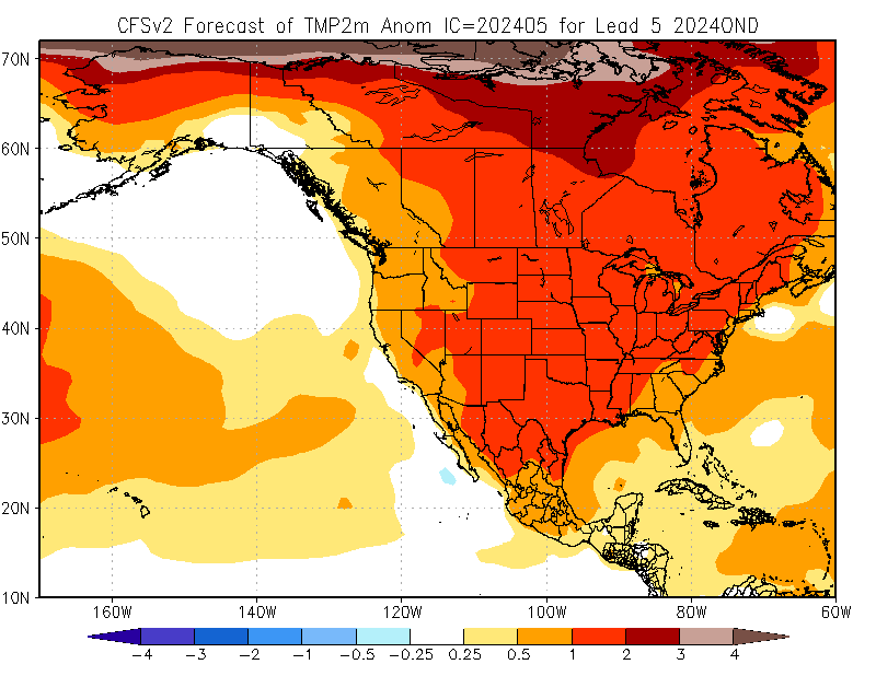 look pretty Nino to me? Pretty edging to 'super' type nino? Again I'd suggest folk pattern match current MJO 30 and 50mb charts as well if they are struggling to see 'where it's coming from'? And another thought; The Pineapple express the west coast is currently under needed the persistant high over the N. Pacific to weaken a little....has this weakened the Trades enough to see the first 'slosh' of warmer waters back east??? As for sst's;  they're beginnig to look positively modoki right now??? EDIT: Just spent a while looking at the various models and the consensus seems to show March as the 'kick off' date so not long to wait eh? |
|
|
|
Post by icefisher on Feb 9, 2014 16:54:40 GMT
Both look pretty Nino to me? Pretty edging to 'super' type nino? Again I'd suggest folk pattern match current MJO 30 and 50mb charts as well if they are struggling to see 'where it's coming from'? And another thought; The Pineapple express the west coast is currently under needed the persistant high over the N. Pacific to weaken a little....has this weakened the Trades enough to see the first 'slosh' of warmer waters back east??? As for sst's; they're beginnig to look positively modoki right now??? EDIT: Just spent a while looking at the various models and the consensus seems to show March as the 'kick off' date so not long to wait eh? I would not put much stock in the models. Their prediction history over the past several years has been far less than stellar even on a multi-model basis until an event has been underway.  The upper panel shows various runs of NOAAs NCEP model. The lower panel which I add here shows the central tracks of a large number of different models located around the world that includes the NCEP model (dark purple squares). The compilation of models consensus of their dynamic models (wide yellow band) shows a brief foray and retreat above the El Nino line this summer. The statistical model consensus (wide green band) shows solid neutral until the end of the prediction window. The consensus of all models dynamic and statistical also predicts continued neutral. Less than half the dynamic models are predicting El Nino conditions this summer. I sure don't know the answer. An El Nino seems missing. Jim Hansen has been looking for it seemingly forever now. But my experience is heavily influenced by the past 40 years and if you look back at the ENSO records to 65 years, extended neutral conditions were not uncommon. El Ninos were so uncommon 35 years ago it was like everybody was shocked when a big one hit in the early 1980's. |
|
|
|
Post by icefisher on Feb 9, 2014 17:25:35 GMT
Here is a wider look at historical model performance: The black squares are actual observations. Dynamic Models:  Statistical Models:  |
|
|
|
Post by graywolf on Feb 10, 2014 13:40:02 GMT
With the studies showing the past 20 years of nino's putting more energy back into the atmosphere ( hence the stunted 2010 one topping global temp charts) i have to look at the strengthened Trades for a reason. If they are effectively pinning the water up in the west Pacific then any interruption,from other teleconnected events, could effectively let the dam loose and allow a rapif nino to form?
With a sudden pattern shift signaled by the forecast SSW I wonder if March is about to see a Nino form?
|
|
|
|
Post by sigurdur on Feb 10, 2014 13:50:02 GMT
graywolf:
I just don't see it happening.
|
|
|
|
Post by karlox on Feb 10, 2014 17:58:21 GMT
With the studies showing the past 20 years of nino's putting more energy back into the atmosphere ( hence the stunted 2010 one topping global temp charts) i have to look at the strengthened Trades for a reason. If they are effectively pinning the water up in the west Pacific then any interruption,from other teleconnected events, could effectively let the dam loose and allow a rapif nino to form? With a sudden pattern shift signaled by the forecast SSW I wonder if March is about to see a Nino form? But most remarkable regarding Sea Surface temp Anomaly and the Pacific is the stubborn hot spot in North Pacific. Which is been coincident with a Blocking High extending through Bering to inner Polar Circle and "pushing" Polar Vortex towards our latitutes...  Regarding current SST you refered can be easily seen here below. Graywolf, please, what changes could we expect in Europe´s coming weather from that event? . It´s being record wettest winter in most parts of Iberian Peninsula but rather cool thugh, not real cold, and very windy- Could SSW such as this trigger a change?to colder? A really nice winter for weather freaks!  50mb Temp Animation Jan 9- Feb 7 50mb Temp Animation Jan 9- Feb 7 |
|
|
|
Post by sigurdur on Feb 10, 2014 22:40:14 GMT
Karlox:
What you are observing in the Pacific in regards to blocking highs is almost a mirror image of what was going in in 1917-1920.
|
|
|
|
Post by sigurdur on Feb 10, 2014 22:43:27 GMT
|
|
|
|
Post by karlox on Feb 11, 2014 7:39:18 GMT
Karlox: What you are observing in the Pacific in regards to blocking highs is almost a mirror image of what was going in in 1917-1920. Sigur, I suppose weather charts -if any- by that time had nothing to do with our current set of data. So what we really have is probably recording and observations of major weather events? Can you address me to where I can get info on 1917-1920 weather explained in "modern" met language? Thanks! |
|
|
|
Post by graywolf on Feb 11, 2014 9:05:04 GMT
Hi Karlox! Only 70% of SSW's come to anything and , of course, at the end of the winter season we get a 'final warming' and what folk are pointing out is just that ( I believe) and so will not have the kind of impacts that gave the UK a 'late winter' this time last year.
Be very careful with Siggys appraisal of that high and the temps it has driven. firstly look at ocean temps in the early 1900's compared with today's and check the base period the anom is set against? See the difference? Many times we see folk comparing to past events and though they appear 'similar' there is always the warming to factor in ( and the extra moisture now held in the atmosphere?)
That 'High' , and the general high temps of the upper oceans, are what concern me. The recent paper on the increase in strength of the Trades over the past 20yrs must be of interest here, it ties in with what we know of the Interdecadal Pacific Oscillation and it's workings ( and wider impacts via teleconnections) and the Trades do exactly the same job in turning over the ocean and drawing down heat/bringing up cooler water. Current short range models not only show the warm dagger of a Nino forming by April but also that blob of high sst's, under the North Pacific high, extending to the coasts and completing the 'Warm PDO' Horse shoe. We have seen PDO-ve add into the Trades ( and favour La Nina ) so the switch to +ve will tend to dampen off the Trades and give us an opportunity to see if we have been having our warming potential 'dampened' by ocean over turning.
Prior to those findings I had wondered how , with warming rates curtailed, the stunted 2010 Nino had managed to overtake the massive global temp hike that the Super Nino had placed into the atmosphere less than 15 years before
.With this new knowledge it becomes clearer that not only do we now have the 'normal nino' impacts but the slackening of the trades allows temperature to rise at their 'new' decadal rate. In 2010 this was still damped by PDO-ve and IPO deep ocean warm phase. This year PDO looks transitional ( at best) and the IPO is at the end of it's Deep Ocean warming phase.
There is nothing we can do about this but for folk more dependant on the weather for their livelihoods any lead time warning of upcoming extremes ought to be a boon? For you and I it's a matter of waiting 8 weeks ( until the sun is over our side of the equator and it's impacts are beginning to be felt in the climate system as the ITCZ pushes north) and seeing if the models are giving good guidance, this time, on the arrival of Nino?
In 97' it took 3 weeks to go from neutral to 'Super Nino' and the modelled ocean temps are looking to be following that example ( though a few weeks earlier in the year). This means the 4 month lag would have global temps responding by Aug/October ( Aug for a Nino ,October if a Super)so maybe we need to look to the 'resilient' high ( over N.Pacific) for the next few months? We have seen that set up the weather ,our side of the pond, for over 8 months now and if it is to remain the only change will be the northerly drift of the Jet? For me here in the UK this means moving out of the firing line of the Lows as they are dragged north and you, to our south, can expect your own High to build in and warm things up nicely?
The wild card is the Arctic. if that high is positioned ( in part ) due to the jolt of energy, injected into the climate system by last years record high energy from the Basin, then any repeat may lead to shuffling along another cycle placing the US under a ridge again ( as in 2009-2012) and a repeat of the UK's trough/Iberian drought? WE then need overlay the growing Nino impact over this base pattern.
We also need to be mindful of the following year which may well bare the brunt of a full Nino? 2010's stunted Nino lead to the largest Arctic Sea ice volume drop we had then recorded.If 2015 is a full Nino year then we must expect another terrible year in the basin and so another 'tweak' to the Jet patterns. 2012 and 13 tweaked the frequency of the Jet ( and amplitude?) so we might expect another shift along for troughs/ridges but what of amplitude? How far can the troughs extend south before they run into the Sub Tropical Jet? What happens when we see that occur? We are accustomed to 'Polar Plunges' dropping the Arctic into lower latitudes but what of a similar exchange of tropical airs north? We know what this drives in the mid west of the US over spring/early summer so would we expect similar across Europe/Eurasia?
|
|
|
|
Post by sigurdur on Feb 11, 2014 15:16:55 GMT
Greywolf:
There really is no credible measurement of ocean temps of the Pacific during that time period. We know that the ocean temps of the North Atlantic were starting to really warm up as evidenced by fish movements, melts on Svalaard, Greenland, Iceland etc.
As far as Pacific, we know there was a pool of warm water off Alaska for 2 reasons. Fishermen and weather patterns.
Other temps in the Pacific? I don't think anyone knows with any degree of certainty. Certain routes were measured with buckets, etc. But that is like driving down Interstate 80 in the USA and saying that the temp of the USA is such and such.
I still don't see an El Nino for 2014.
When you talk about how great it would be for folks to be able to use predictions......boy are you correct. The problem with today's predictions is that the reliability set has not improved at all.
Short term weather has gotten to be approx 55% correct. Long term weather? I keep track of this crap....and it is less than 50%. It is almost...if the models are saying one thing, the odds are the exact opposite is going to happen.
Kinda like last year......in Ag....long range forecasts from the year before...and even up through Jan......WARM and Dry.
How did that turn out?......it didn't.
That is only one example....go back years further and you realize how poor the understanding of climate/weather is to this day.
Keep forecasting a Nino and eventually one will be correct.
|
|
|
|
Post by graywolf on Feb 11, 2014 20:20:13 GMT
|
|
|
|
Post by icefisher on Feb 11, 2014 21:30:26 GMT
76% confidence is pretty poor. The IRI/CPC compilation of models is close to a 76% liklihood based upon dynamic models only. Further, history suggests that we are in an El Nino phase right now and have been for a while. 3 out 4 last Enso events have been La Ninas. It rarely has gotten more lopsided than that. So in almost all respects (historic patterns only) we should have an El Nino.
But in saying in all respects (historic patterns) thats just a bunch of statistical facts, as is this study that Graywhale is pointing to. You might say its the only statistical model pointing at El Nino under the current observation conditions (which are countering the in "all respects' historical patterns. Sort of suggests the dynamic models continue to rely on ocean heat and perhaps the input of the missing heat into the ocean as well.
Since the researchers said it was not able to predict the forcing of the event and the most they had to say as to its skill that it correctly predicted the previous two non-el nino events (when I presume other models had predicted them) its a very weak statement of skill.
Seems to be nothing whatsoever in this study at any rate to suggest a strong El Nino event and far less to suggest record global temperatures. But I guess you have to keep tossing hope to the true believers in carbon action to keep the confidence up that they are on the right path.
An El Nino event would not surprise me. I am not predicting an El Nino but thats because I lack skills and the people with skills are largely not predictinng it. It would not surprise me at all to see another 1998, 2005, 2010 like global temperature peak. I would be surprised to see a temperature peak that shattered those levels by .2degC however. Even beating it by a full .1C on a majority of databases would be surprising.
|
|


