|
|
Post by sigurdur on Jul 18, 2014 12:24:03 GMT
[ Snip ] We of course know that AGW is responsible for the position of the Rosbys and the 6 week cycle in regards to weather. Sig, can you please list all the other things that AGW is responsible for? No need to include the loss of redheads or snow, cos I already know about thaem.  I am old enough that I would be a goner before I got done with it. |
|
|
|
Post by sigurdur on Jul 18, 2014 17:06:07 GMT
|
|
|
|
Post by dontgetoutmuch on Jul 18, 2014 21:45:32 GMT
I have to agree it is starting to look like the promised El Nino is El Not Happening. Popcorn futures and heating oil futures are up...
|
|
|
|
Post by Ratty on Jul 18, 2014 23:17:53 GMT
|
|
|
|
Post by icefisher on Jul 19, 2014 4:40:47 GMT
this is getting hilarious! Last month they showed a cooling month and a recovery beginning in July. Come early July they revised to a slight recovery. Now by mid July the cooling is steepening and the models still expect a recovery. . . . next month of course!Last Month: 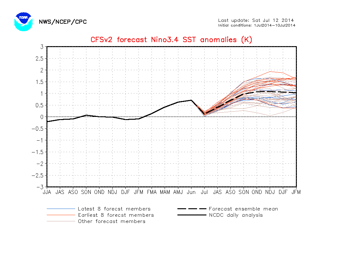 This Month:  |
|
|
|
Post by dontgetoutmuch on Jul 19, 2014 15:20:12 GMT
The models were all designed to model ENSO in the context of a warm PDO. Using them now is sort of like using a model that was designed to tell you when to mow your grass in the winter. The model just does not have the concept of seasons built into it, and it cannot tell why the grass in not growing under the snow.
|
|
|
|
Post by Ufasuperstorm on Jul 19, 2014 16:44:57 GMT
The wheels continue to fall off. We now have a negative upper ocean heat anomaly in the nino regions. The 0-300 meter depth temperatures are a good indication where SST's are headed. 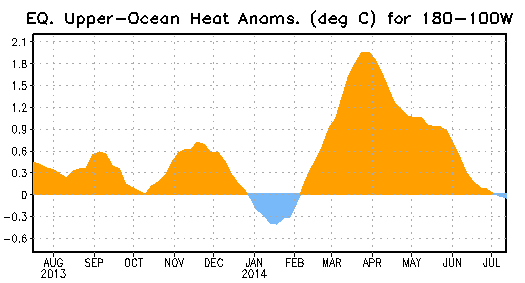 Updated 7 day SST forecast. 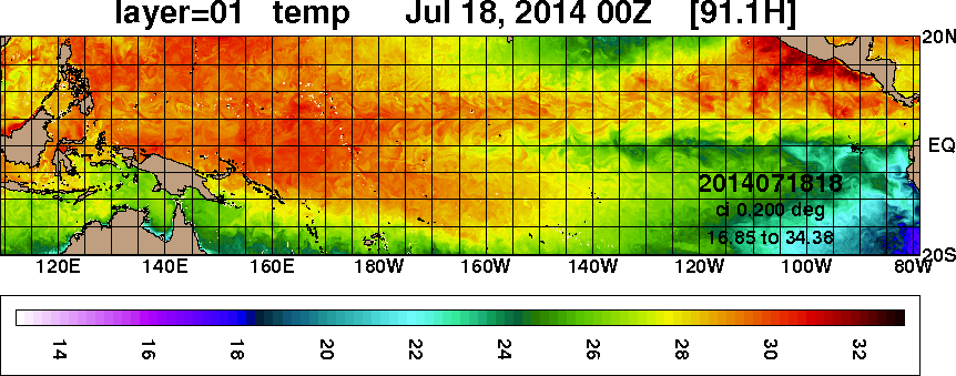 Here is the past 23 days loop plus 7 day forecast. www7320.nrlssc.navy.mil/GLBhycom1-12/navo/equpacsst_nowcast_anim30d.gifComparing observations with the models forecast would seem to indicate a bit of a cold bias. Reality  Forecast on Monday 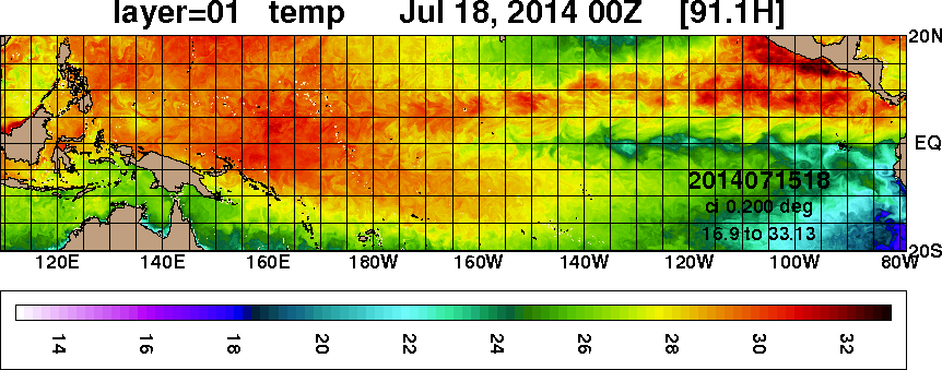 Never the less moderate cooling continues. |
|
|
|
Post by sigurdur on Jul 19, 2014 17:16:13 GMT
Well,my hope for an El Nino is getting a cold shoulder.
|
|
ant42
Level 3 Rank
 Melbourne, Australia
Posts: 129
|
Post by ant42 on Jul 19, 2014 23:58:43 GMT
WB still thinks it will be a modoki.
Hard to see what will drive it, the heat in the subsurface, or whatever is left of it, is being eroded.
At the moment the Easterlies are strongest in the western Pacific, which is why that SST forecast may have been a tad cold biased.
But they will pick up again near the SA coast next week, so cooling will continue.
What the models are seeing is a mystery, you can discount CFS because its the most reactionary model there is and no good long term IMO.
Jamstec and the rest still think it will come on, i think they are dreaming.
|
|
|
|
Post by AstroMet on Jul 20, 2014 1:12:40 GMT
The models were all designed to model ENSO in the context of a warm PDO. Using them now is sort of like using a model that was designed to tell you when to mow your grass in the winter. The model just does not have the concept of seasons built into it, and it cannot tell why the grass in not growing under the snow. I don't enjoy having to say, "Told you so," but have to once again on these calls on a 'Super El Nino' which was nothing but a pipe dream by those playing at computer modelling forecasting and spreading their so-called forecasts as propaganda when all they see time after time are busts of their forecasts. When I forecasted the multi-year drought that I said would spread west into California and dry that state out to its extremes, I wasn't kidding. Meanwhile, most of us have been watching as NOAA and other international climate centers try to back away (but don't really want to as yet) from their calls for a 'Super El Niño' that was going to save California and the American west coast from blistering heat and extreme drought. Consider this July 19, 2014 report from Salon on El Niño: El Niño may not be able to save California
The Golden State issues statewide water restrictions as it prepares for the worst drought in its history
California has imposed statewide water-use regulations for the first time as its three-year drought worsens.
Yesterday, state regulators approved stringent new measures limiting outdoor water, which include $500 fines for using an outdoor hose without a shut-off nozzle.
Meanwhile, hopes that the drought would break by autumn have been tempered. The National Weather Service’s Climate Prediction Center downplayed the help that El Niño may bring to the drought-plagued West in its monthly report of Pacific Ocean weather patterns. While the Center is still projecting that sea surface temperatures will be warmer than usual—a phenomenon known as El Niño—it is now saying that the effect will be only “weak to moderate.”
The forecast strength of the El Niño was downgraded because Pacific Ocean temperatures near the International Date Line have not continued to rise since earlier this year when they were well above average.
While strong El Niño weat?h?er patterns usually create more rain for California, weaker El Niños typically don’t bring more rains to the region.
The Center said that there is a 70% chance El Niño will develop by the end of the summer, and an 80% chance that one will develop by the early winter.
Australia’s Bureau of Meteorology concurred with U.S. climate forecasts in a press release yesterday. It further suggests that El Niño has been effectively counteracted by the arrival of cooler water.
All of California is under drought conditions and will likely remain that way through autumn. Reservoirs are precariously low in many places. The nation’s largest reservoir, Lake Mead in Nevada, is now at an all-time low.
It is the first time in 15 years that the entire state suffers from a water shortage. The U.S. Drought Monitor, a government-funded weekly map of drought conditions, says that the entire state now suffers from conditions ranging from “abnormally dry” to “exceptional drought.”
Heavy-population centers all suffer from “extreme drought” or “exceptional drought.”
El Niño refers to a recurring weather pattern that develops in the southern Pacific near South America. Usually, scientists can predict El Niño a few months before it occurs. Researchers say it can spark droughts in Australia and increase rain and floods in parts of the U.S. and South America.
Land areas bordering the Pacific Ocean are the most affected. El niño is Spanish for “the boy” and the capitalized term El Niño refers to the infant Jesus, because periodic warming in the Pacific near South America usually begins near Christmas. The most recent occurrences of El Niño were in 2006 and 2009.
The drought is hitting the farm industry and its workers particularly hard.
The Central Valley, one of the world’s richest food-producing regions, is up against what geologists are calling the 500-year drought.
Fresno County, the heart of the Central Valley’s San Joaquin Valley farm belt—and the number one farming county in the nation—may lose up to a quarter of its orchards and fields this year for lack of water.
The state’s farmers have idled about 800,000 acres this year. As a result, consumers can be expected to pay more at the grocery store for a wide range of staple foods.
The Department of Agriculture warns that “major impacts from the drought in California have the potential to result in food price inflation above the historical average.”
?California ?Governor Jerry Brown declared a state of emergency in January when it became clear that 2013 closed out the driest year ever recorded for many parts of the state and the 2014 “water year,” which began October 1, had thus far been the driest in 90 years."This claim that scientists can predict an El Niño is bogus as NOAA has never done that. These claims of being able to predict one yet at the same time unable to do just that in reality is contradictory, isn't it? Still, even at this juncture, in mid-July, when it is obvious that things will cool off (at least some people now get what I've been saying about no El Niño) we still hear modellers in denial, wishing for their glorious forecast of a 'super El Niño' to save the day for California. That is not going to happen. It continues to be my medium-range forecast that California will see climate matters go from bad to worse with another very dry year ahead in 2015 (the hottest & driest year yet for the western US) which will see unprecedented calls for help from every quarter because of no precipitation - no water. And when it does begin to rain in California, the situation will be dire with all the mudslides, but we won't see relief for California until mid-2017, early 2018, according to my calculations. It's going to get that bad in California and I tell everyone that El Niño is not going to ride in for a rescue either. |
|
|
|
Post by nautonnier on Jul 20, 2014 19:40:15 GMT
"The drought is hitting the farm industry and its workers particularly hard."
While there is no doubt there is less rain, it must be understood that the major problems with water are due to the EPA regulations on preserving species of fish they claim are 'threatened' (such as the delta smelt which has since been found in other areas and is not threatened). These restrictions on the use of water from lakes and rivers, result in huge amounts, probably more than half, of the fresh water in California draining straight into the Pacific. The federal agencies are deliberately exacerbating the impact of the drought - which demonstrating their lack of historic knowledge, they blame on 'climate change'.
The population of California is increasing without the support infrastructure for that increase. Mainly supply of fresh water as the resource becomes scarce so entrepreneurs step in and start making money from supplies of water and force the price higher to increase profits. In consequence the water companies have no problems whatsoever with federal agencies making water more scarce. There is a distinct possibility that Los Angeles could actually run out of water if the current approaches to drinking water supplies are continued. It would seem sensible for the EPA for once to put human survival first and for the state to look at creating desalination plants they could be nuclear powered. But Californian politicians are using their current surfeit of sand to bury their collective heads and not see the problem - it is probably too late now to take effective action.
|
|
|
|
Post by sigurdur on Jul 22, 2014 14:55:27 GMT
The 2014 El Nino looks like it is cooked. If it can even get to El Nino status, it is going to be one heck of a weak one.
OH well, always hope for next year.
|
|
|
|
Post by sigurdur on Jul 22, 2014 15:28:28 GMT
www.bbc.co.uk/programmes/p022tlhqWhat has Happened to El Nino? Duration: 29 minutes First broadcast:Monday 21 July 2014At the start of 2014 meteorologists warned of a possible El Nino event this year. The portents were persuasive – a warming of the central Pacific much like that which preceded the powerful El Nino event of 1997. But since then the Pacific climate system seems to have stalled. What’s going on? What are the prospects for an El Nino to develop later this year? What impacts might it have? Roland Pease delves below the Pacific surface to find out what drives El Nino cycles, the most powerful single climate fluctuation on the planet, and asks the experts why it is so hard to forecast. “The year started with a bang,” one expert tells Discovery - will it end with a whimper? (Photo: Burned swamp forest in Kalimantan. Credit: Florian Siegert, RSS GmbH) ? Show less At the start of 2014 meteorologists warned of a possible El Nino event this year. The portents were persuasive – a warming of the central Pacific much like that which preceded the powerful El Nino event of 1997. But since then the Pacific climate system seems to have stalled. What’s going on? What are the prospects for an El Nino to develop later this year? What impacts might it have? Roland Pease delves below the Pacific surface to find out what drives El Nino cycles, the most powerful
|
|
|
|
Post by icefisher on Jul 23, 2014 0:29:55 GMT
"warm like gangbusters"
LOL! Does that mean its going to be like last time?. . . . A whole .75degC per century when you consider both the pause and the gangbuster warming??
And thats after scientists looked with a fine tooth comb into the temperature record to find data to adjust or eliminate to lower the 1940's peak warming. I doubt this nonsense can continue much longer. The record quiet we are seeing in the sun seems poised to give the CAWG crowd a rude awakening. As it is they are heavily invested in history repeating itself and are wearing blinders to what the amplitude of warming as usual amounts to. . . .meanwhile good ol sol is rapidly turning back the hands of time. For most of the last 7 years that looked like a 100 years, but its looking more and more like 200 years if not more. Thats not a prediction because I have no idea whatsoever what the sun is apt to do. . . .just pointing out the direction things are currently pointed at.
|
|
|
|
Post by sigurdur on Jul 26, 2014 14:07:29 GMT
|
|