|
|
Post by sigurdur on Nov 6, 2014 17:02:40 GMT
Yep, will have to see what Northern Hemisphere winter brings. Sure has been a long time coming tho, so one of these years it will actually happen.
|
|
|
|
Post by AstroMet on Nov 6, 2014 19:38:11 GMT
Noaa released their monthly update today and as I predicted they continue to back off. So they are no longer favoring an El Niño to start this year. (Do not let the recent spike in SST's fool you as it will be short lived) www.cpc.ncep.noaa.gov/products/*ble...y/ensodisc.htmlThe CPC/IRI Consesus Probabilities coninue to decrease. (Lowest they have been in the last 12 months)  The corrected Probability Density Function forecasts are showing some cooling over the next couple months.(Starting at the end of November) Spring 2015 anyone?   As I forecasted, there would be no El Nino. If you go back to all the 'super El Nino' talk this year you will see why you cannot believe everything you read, especially about such silly wishful thinking forecasts that wasted the time of many around the world. As for spring 2015 in the northern hemisphere, I have forecasted that spring will come earlier-than-normal and will be warmer than normal leading to a very warm and long summer season that will extend well into autumn 2015. |
|
|
|
Post by Ufasuperstorm on Nov 6, 2014 19:48:56 GMT
The fact of the matter in reality the probability of an El Niño is now less likely then anytime in the last 12 months. (And some folks and meteorologist are acting like it is the highest) They need to learn to ignore the background noise. In NOAA's blog update they sound much less confident and are already starting to make excuses. If you read through the previous entries they have a much higher confidence and are trying to make excuses why an El Niño has not materialized as of yet. The ONI value for ASO was 0.2. Meteorologist and the majority of the folks in these forums also do not realize the CFSv2 forecast that they have been posting on forums or on their websites is not the models official forecast. When you model any real world problem you need to map the observed PDF to the forecast PDF to make an accurate forecast. (You need the raw model output to start with before you can correct it.) The model I have been posting is the PDF corrected. There will be many excuses upcoming in the next several months. If you google search El Niño you will already find some of them. www.climate.gov/news-features/blogs/enso/details-november-enso-forecast-slip-slidin%E2%80%99-awayPrediction: In NOAA's December update probabilities will falll below 50% and they will push the start of El Niño to Spring 2015. |
|
|
|
Post by icefisher on Nov 8, 2014 5:10:08 GMT
The universities that produce the ENSO predictions have zero, and probably negative skill (negative skill arising out of a complete misconception of how the climate actually works). NOAA is not bad on the short range forecasts the bureaucrat scientists are less greened and actually do science as opposed to fund raising (read science as ordered) at wine and cheese parties like the universities do without a shred of accountability except to their funders. (not any real difference from the cadre of scientists that surrounded the Pope 500 years ago, uninspired followers hardly a leader to be seen in their midst.)
The long range forecasts currently rather clearly predicated on the belief that heat has been gathering in the oceans and just has to begin to show itself sometime in the near future. Columbia University that chairs this group is the home of Dr. James "El Nino is the new normal" Hansen. As a result the long range forecasts have been over heated for the entire 5 years I have been watching them.
Such terrible consistency of just being wrong suggests strongly a negative skill. Even blind squirrels more occasionally find acorns than Columbia University.
|
|
|
|
Post by graywolf on Nov 20, 2014 14:21:49 GMT
I found this interesting; www.ciifen.org/index.php?option=com_content&view=category&layout=blog&id=117&Itemid=172&lang=esesp. their noting that though prediction had been improving that something has rendered those improvements near useless over the past 10 yrs? I'm seeing some measure of atmospheric cooperation now developing and so would expect us to slip into a Nino as winter progresses but I'm also still thinking that we have too much 'fuel' for the nino to remain small and stunted so will be watching for it ramping up as winter nears its end ( late Jan early Feb)...... we've seen a few years now try and form a Nino over late winter only for the trades to then squish it by mid summer ( as they ramp up again), this time we will enter that period with atmospheric cooperation already in place? Surely this will make the world of difference? I see we are also still seeing strong positive PDO numbers? I imagine as long as this 'near Nino' continues so will this PDO positive, the longer this Near Nino goes on the closer we will be to seeing PDO positive asserting. |
|
|
|
Post by dontgetoutmuch on Nov 20, 2014 15:29:52 GMT
I believe that the ENSO forecast models reliability, or rather unreliability has increased in the past decade because the models were tuned during the warm PDO phase, but did not incorporate the affects of a variable PDO into the model. This means their models cannot "see" the PDO, or the affect it has on ENSO. The models always initialize with the meteorological conditions consistent with a warm PDO, regardless of the actual conditions of the PDO. In other words, garbage in...
|
|
|
|
Post by dontgetoutmuch on Nov 20, 2014 15:34:14 GMT
I found this interesting; www.ciifen.org/index.php?option=com_content&view=category&layout=blog&id=117&Itemid=172&lang=esesp. their noting that though prediction had been improving that something has rendered those improvements near useless over the past 10 yrs? I'm seeing some measure of atmospheric cooperation now developing and so would expect us to slip into a Nino as winter progresses but I'm also still thinking that we have too much 'fuel' for the nino to remain small and stunted so will be watching for it ramping up as winter nears its end ( late Jan early Feb)...... we've seen a few years now try and form a Nino over late winter only for the trades to then squish it by mid summer ( as they ramp up again), this time we will enter that period with atmospheric cooperation already in place? Surely this will make the world of difference? I see we are also still seeing strong positive PDO numbers? I imagine as long as this 'near Nino' continues so will this PDO positive, the longer this Near Nino goes on the closer we will be to seeing PDO positive asserting. So, Graywolf is still seeing a "Super Nino" in the near future. One of these years, he might be right. On the other hand, I only have forty or so good years left in me, so I won't really care when he gets to crow about it. |
|
|
|
Post by icefisher on Nov 20, 2014 17:29:59 GMT
I believe that the ENSO forecast models reliability, or rather unreliability has increased in the past decade because the models were tuned during the warm PDO phase, but did not incorporate the affects of a variable PDO into the model. This means their models cannot "see" the PDO, or the affect it has on ENSO. The models always initialize with the meteorological conditions consistent with a warm PDO, regardless of the actual conditions of the PDO. In other words, garbage in... Exactly, its purely inductive logic formed from the assumption that the future will look like the past. When you have a multidecadal oscillation and you base your models on a decade and a half of climate information as did the IPCC once the oscillation changes it proves your models are crap as far as ENSO predictive skill is concerned. Lets just hope that Greywolf has grant income dependent upon the popularity of global warming so that we need to think of him as a fool. It actually is rather odd that the heat that was building in the oceans over the past decades have not manifested itself via El Nino. We saw at least a couple of decades of ocean warming where the ocean warmed up by about a 1/2 degree. That sufficient to make El Nino the new normal as was declared by James Hansen several years ago. But ocean data charts have not been updated in over a half a decade, obviously because the information is not satisfying the needs of those with a grip on funding sources. The question is obvious, even with shifting baselines, the baseline temperatures assuming level ocean temperatures should still be two decades behind the leveling and El Ninos should be more common than La Ninas. But instead we are seeing a record length hiatus without an El Nino. This includes 30 years (1950 to 1980) when ostensibly the last cold oscillation/PDO was in place. Why is that? NOAA models are showing the beginnings of an El Nino but over the period of time NOAA has any shred of reliability (a couple of months) they are predicting weakening of the El Nino condition. Beyond that they predict an El Nino put they have zero skill in that range of prediction. |
|
|
|
Post by sigurdur on Nov 20, 2014 21:11:19 GMT
|
|
|
|
Post by sigurdur on Nov 20, 2014 23:26:44 GMT
I found this interesting; www.ciifen.org/index.php?option=com_content&view=category&layout=blog&id=117&Itemid=172&lang=esesp. their noting that though prediction had been improving that something has rendered those improvements near useless over the past 10 yrs? I'm seeing some measure of atmospheric cooperation now developing and so would expect us to slip into a Nino as winter progresses but I'm also still thinking that we have too much 'fuel' for the nino to remain small and stunted so will be watching for it ramping up as winter nears its end ( late Jan early Feb)...... we've seen a few years now try and form a Nino over late winter only for the trades to then squish it by mid summer ( as they ramp up again), this time we will enter that period with atmospheric cooperation already in place? Surely this will make the world of difference? I see we are also still seeing strong positive PDO numbers? I imagine as long as this 'near Nino' continues so will this PDO positive, the longer this Near Nino goes on the closer we will be to seeing PDO positive asserting. Greywolf: What atmospheric coupling are you observing? The trades seem well within their normal intensity. I haven't looked at 0-100M water temps around and north of Aussie to see if there is actually a pool of warmth to draw from. Do you have any information on this? |
|
|
|
Post by icefisher on Nov 21, 2014 0:44:39 GMT
I found this interesting; www.ciifen.org/index.php?option=com_content&view=category&layout=blog&id=117&Itemid=172&lang=esesp. their noting that though prediction had been improving that something has rendered those improvements near useless over the past 10 yrs? I'm seeing some measure of atmospheric cooperation now developing and so would expect us to slip into a Nino as winter progresses but I'm also still thinking that we have too much 'fuel' for the nino to remain small and stunted so will be watching for it ramping up as winter nears its end ( late Jan early Feb)...... we've seen a few years now try and form a Nino over late winter only for the trades to then squish it by mid summer ( as they ramp up again), this time we will enter that period with atmospheric cooperation already in place? Surely this will make the world of difference? I see we are also still seeing strong positive PDO numbers? I imagine as long as this 'near Nino' continues so will this PDO positive, the longer this Near Nino goes on the closer we will be to seeing PDO positive asserting. Greywolf: What atmospheric coupling are you observing? The trades seem well within their normal intensity. I haven't looked at 0-100M water temps around and north of Aussie to see if there is actually a pool of warmth to draw from. Do you have any information on this? We have been down this road before with Graywolf. The "too much fuel for the nino to remain small and stunted" Graywolf is referring to is the CAGW gospel that some unknown process not only is stunting ENSO but is sequestering massive quantities of heat at the bottom of the ocean. |
|
|
|
Post by sigurdur on Nov 21, 2014 1:52:11 GMT
Greywolf: What atmospheric coupling are you observing? The trades seem well within their normal intensity. I haven't looked at 0-100M water temps around and north of Aussie to see if there is actually a pool of warmth to draw from. Do you have any information on this? We have been down this road before with Graywolf. The "too much fuel for the nino to remain small and stunted" Graywolf is referring to is the CAGW gospel that some unknown process not only is stunting ENSO but is sequestering massive quantities of heat at the bottom of the ocean. Well, that heat in the bottom of the ocean isn't there according to oceanography. Could be there isn't any excess heat in fact. |
|
|
|
Post by graywolf on Nov 21, 2014 11:04:34 GMT
Hi Siggy! I'm looking at the 'long paddock' data from BOM which has been well negative for a number of weeks now?
As for why the 'fuel' has not been able to be used it is the strength of the Trades ( which hold the waters in the west) to blame and these , we are told, are at record levels due to the walker cell working overtime to balance the temps between tropical Atlantic and Pacific. It would appear that these basins are now approaching parity and so the buffed up walker cell will relax and hence the trades will fall light.
The past 4 or 5 years have seen Nino forecast in late Nov/December and we have even seen a couple of instances where the Nino looks to be getting started only for the trades to again pick up come June/July. Could Northern summer be a case for this and southern summer ( over mainly ocean) be the reason we see the trades drop back in late Jan/Early Feb?
Anyhow it does appear that we are seeing change? PDO has stayed positive for the past 10 months and plenty of Nino impacted areas are acting like Nino is already up and running? Once again we see the agencies going for Nino conditions from now on but I'd again say that I'm expecting another record Kelvin wave to develop and push east? Should the trades not intervene come summer then I think we will see a steadily growing Nino as wave after wave pushes out and the height of the warm pool begin to reduce? Of course this would also see the IPO shift positive as the winds fall light and ocean surface heating replaces the subduction of this heating?
PDO positive, IPO positive, Nino conditions prevalent? all we need is for China's particulate pollution to plummet and we might get a real feel for where global temps are headed?
EDIT: Another global record warm month for October then? ( knocking September off the top spot) and a record warm first 10 months of the year? Looking like a record warm year might well be the result of this ENSO neutral, alleged PDO negative?IPO negative Arctic recovery type of a year eh?
|
|
|
|
Post by throttleup on Nov 21, 2014 22:34:13 GMT
Graywolf (I love ya!): "Another global record warm month for October then? (knocking September off the top spot) and a record warm first 10 months of the year? Looking like a record warm year might well be the result of this ENSO neutral, alleged PDO negative? IPO negative Arctic recovery type of a year eh?"Graywolf, you live on a wonderful planet. I just wish I knew which one it was!  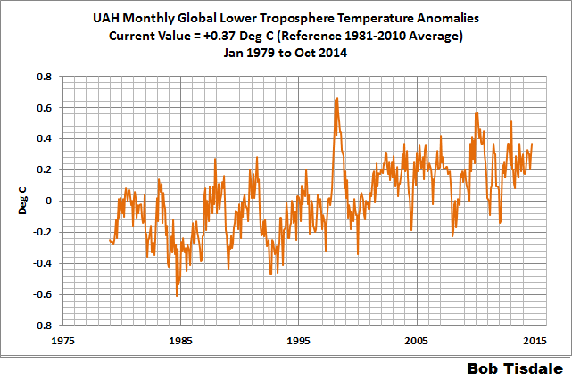 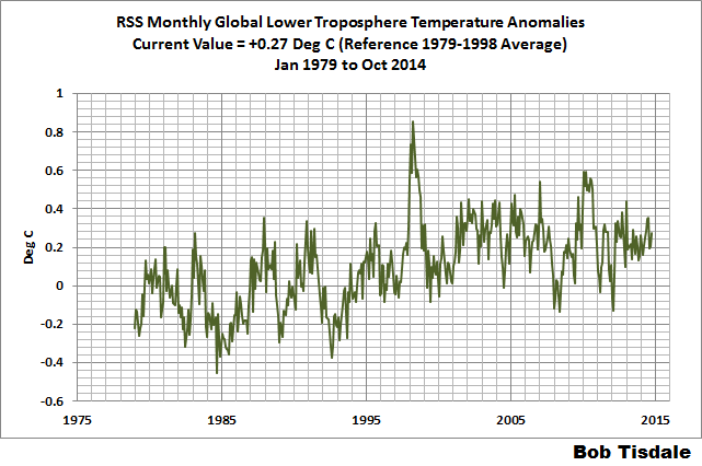 |
|
|
|
Post by sigurdur on Nov 22, 2014 1:38:43 GMT
Greywolf:
Careful that you recognize that the SOI has a seasonal tendency. Declining during Sept-Feb.
|
|