|
|
Post by sigurdur on Feb 16, 2014 19:01:31 GMT
Where I live, we have been cooling over 10.7F per decade. I will state that weather was a hell of a lot more stable when we were warming.
In fact, the last few years has brought us below the 100 year mean temperature in this neck of the woods.
|
|
|
|
Post by cuttydyer on Feb 16, 2014 20:03:22 GMT
Where I live, we have been cooling over 10.7F per decade. I will state that weather was a hell of a lot more stable when we were warming. In fact, the last few years has brought us below the 100 year mean temperature in this neck of the woods. also rapid cooling here in the UK:  |
|
|
|
Post by sigurdur on Feb 17, 2014 1:58:00 GMT
Bill Illis says: February 15, 2014 at 4:45 am There are forecasts of a developing El Nino this year primarily because of the build-up of warm water in the equatorial undercurrent. Jan 2014 here. The big red spot. www.cpc.ncep.noaa.gov/products/GODAS/mnth_gif/xz/mnth.anom.xz.temp.0n.2014.01.gifThis fairly large red spot normally flows under the Pacific surface to the east and surfaces at the Galapagos Islands where it can lead to an El Nino if it is warm or a La Nina if it is cold. But this currently warm water has to fight its way through the rest of the equatorial Pacific’s cold water in the eastern half in order to still be warmer than average when it makes its way to the Galapagos. www.cpc.ncep.noaa.gov/products/GODAS/mnth_gif/xy/mnth.anom.xy.h300.2014.01.gifThis is “exactly” the same set-up for the previous two years. In those two years, an El Nino looked very likely, started to develop, but came to a sputtering end. Because all the cool water in the east, returned the undercurrent to normal temperatures. www.cpc.ncep.noaa.gov/products/GODAS/mnth_gif/xz/mnth.anom.xz.temp.0n.2012.01.gifwww.cpc.ncep.noaa.gov/products/GODAS/mnth_gif/xy/mnth.anom.xy.h300.2012.01.gifwww.cpc.ncep.noaa.gov/products/GODAS/mnth_gif/xz/mnth.anom.xz.temp.0n.2013.01.gifwww.cpc.ncep.noaa.gov/products/GODAS/mnth_gif/xy/mnth.anom.xy.h300.2013.01.gifSame set-up, likely to be the same result. In essence, it is why a cold PDO leads to more La Ninas and fewer El Ninos. Lots of other factors to consider. Trade Winds, SOI, OLR/cloud patterns at the International Dateline, the Peru-Humbolt current SSTs, Atmospheric Angular Momentum, equatorial surface currents – all of which are not pointing to an El Nino. |
|
|
|
Post by sigurdur on Feb 17, 2014 1:58:18 GMT
|
|
|
|
Post by Ratty on Feb 17, 2014 3:14:53 GMT
|
|
|
|
Post by sigurdur on Feb 17, 2014 3:37:12 GMT
In fricken believable.
|
|
ant42
Level 3 Rank
 Melbourne, Australia
Posts: 129
|
Post by ant42 on Feb 17, 2014 7:45:34 GMT
Not sure if you saw my post sigurdur on WUWT, but I think it will struggle as well.
I would like to see one because the La Nina that follows will be enormous.
And the 2009/10 El nino here was extremely bizarre because instead of droughts we had loads of storms and rain from late Nov 2009 right through the summer until the end of Feb.
And our weather currently is almost a carbon copy, record heat, then an average period, then very hot Sept/Nov, then all hell breaking loose.
Time will tell if this is going to be the same, but to me the warm water is too far advanced to have any impact in the last quarter of this year, by then this heat will be long gone and surfaced, with cold water following it.
I think I read here that 1949 was the last time we went LA nina after neutral so it could happen again, but rarely.
|
|
|
|
Post by graywolf on Feb 17, 2014 11:07:35 GMT
PDO popped a big positive in Jan....Let's see what Feb brings to it as the slight die down of the trades , to allow in the Pineapple express , certainly upped Nino 4/3.4 ssts over the past week?
|
|
|
|
Post by phydeaux2363 on Feb 17, 2014 19:37:46 GMT
Let's see if Mr. Wolf's predictions on El Nino are as accurate as his 2013 Arctic ice minimum analysis? Or maybe better than Dr. Hansen's temp predictions from the 80s? Guess it's possible that even a blind wolf catches the rabbit sometime?
|
|
|
|
Post by sigurdur on Feb 17, 2014 23:27:35 GMT
Still don't see it. The warm pool of water did move a bit east, but the tail end of the slide show showed it started to get smaller. So.........I still just can't see much of a chance.
IF.....and that is a big IF.....one does develop.....the sucker is going to be so weak as to be barely detectable. Just not enough hot water to get er done.
|
|
|
|
Post by graywolf on Feb 19, 2014 13:32:42 GMT
Plenty of warm at depth as the wave propagates east? Latest update also going for a M/J/J start to the Nino?
The problem has to be those strengthened Trades? Are they why we saw failed Ninos the past couple of years ( and the stunted 2010 event?)? Is this event signalling the end to the current IPO phase with PDO following suit?
Sure will be an interesting time should we see IPO switch to warm surface phase and we see the Trades fade away? Both for ENSO and the Antarctic PIG complex.
|
|
|
|
Post by nautonnier on Feb 19, 2014 20:11:09 GMT
Plenty of warm at depth as the wave propagates east? Latest update also going for a M/J/J start to the Nino? The problem has to be those strengthened Trades? Are they why we saw failed Ninos the past couple of years ( and the stunted 2010 event?)? Is this event signalling the end to the current IPO phase with PDO following suit? Sure will be an interesting time should we see IPO switch to warm surface phase and we see the Trades fade away? Both for ENSO and the Antarctic PIG complex. Looking at this EARTH wind map the winds do not appear to favor the creation of an El Nino all those North Easterlies into Indonesia. And the surface anomalies at the moment would be a strong La Nina if it wasn't for the large cold pool off the coast of South America  Drake Passage looks very cold considering its the end of the Summer - the North Atlantic Drift seems to have stopped, and its source in the gyre in the Gulf of Mexico is very cold too. We will see what transpires, it will be an interesting year. One thing that can be forecast with absolute certainty is that whatever happens will be said to be 'due to climate change'. |
|
|
|
Post by duwayne on Feb 19, 2014 21:16:54 GMT
There seems to be a general agreement here that statistically we’re due for an El Nino. I don’t pretend to be able to predict the monthly ENSO oscillations, but I did note a few months back that based on the 1947-77 cool cycle an El Nino occurred about this time in the cycle and I surmised that the warm Kelvin wave underway in mid-2013 could lead to an El Nino. But that didn’t happen. Another warm Kelvin wave is now underway and this might be the time for the expected (sooner or later) El Nino. 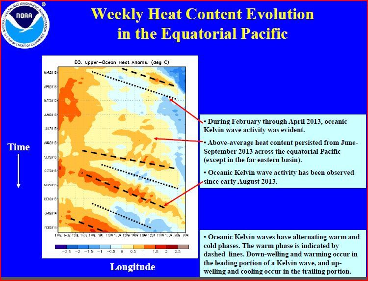 The El Nino 60 years ago was immediately followed by a strong La Nina which contributed to the domination of La Ninas over El Ninos during the 1947 to 1977 period. The January PDO was 0.30. It’s the first positive monthly reading for more than 3 years. There has'nt been an annual average PDO reading above zero since 2006. During 1947-77 the annual average PDO was negative 81% of the years. So statistically speaking, a positive PDO can be expected about 1 out of 5 years during a cool PDO cycle. After 7 years of negative annual readings we’re overdue for a positive annual PDO reading. So far the 2007-2037 cool ocean current cycle is continuing to pretty much replicate the 1947-1977 cycle pattern. The AMO continued its slide and went negative in January. |
|
ant42
Level 3 Rank
Melbourne, Australia
Posts: 129
|
Post by ant42 on Feb 20, 2014 4:57:02 GMT
Latest Jamstec is out and now are going for a Modoki.
Seems about right, just not enough heat to make it all the way to 1 and 2 in this current domination of the cold PDO.
As much i want to see the El nino come on i think its going to struggle to get through the cold water as it moves East.
The fascination for me is whether we go straight into a La Nina next year or whether we have another weak warming this time next year.
|
|
|
|
Post by graywolf on Feb 21, 2014 20:25:02 GMT
|
|


