**Astromet's Climate Forecast: Winter 2014-2015**
Oct 29, 2014 1:34:52 GMT
sigurdur, scpg02, and 5 more like this
Post by AstroMet on Oct 29, 2014 1:34:52 GMT
Astromet’s General Climate Forecast
Winter 2014-2015
Spring, Summer & Autumn 2015
‘A Quick Cold Winter, Early Warm Spring & Blazingly Hot & Long Summer & Autumn’
Published: 28 October 2014
Forecast by Theodore White, astrometeorologist.Sci
As we near the winter of 2014 and the solar years of 2015 and 2016, we will experience the last remaining years of solar-forced global warming.
These years – 2015 and 2016 - will be warmer and drier than normal with record setting temperatures before we reach the abrupt climate year of 2017, which will usher in the official start of global cooling.
I continue to remind of my long-range climate forecast for global cooling which I made in the last decade to arrive, officially, by mid-December 2017.
My forecast is that this new climate state will last approximately 36 years and produce some of the worst cold and wet climate conditions the world has seen in modern times during the 2020s, 2030s and 2040s.
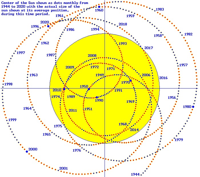
My astrometeorological forecasting is complex as I synthesize all the known positions of the planets of our solar system and the Earth relative to the Sun's condition as well as the position of the Barycenter.
I then integrate all these factors into my seasonal climate forecasts as well as long-range climate forecasts.
The trending to global cooling with the Sun’s coming Grand Minimum will usher in a brutally cold and wetter climate for the Earth that should be prepared for well in advance - and time runs short.
As many valuable years have been wasted by nations and their governments on the impossibility of ‘man-made global warming,’ few countries and their populations are prepared for global cooling and will suffer as a result.
For the shorter-term, my general climate forecast for the coming winter of 2014-2015 is as follows:
WINTER 2014-2015:
A cold winter with fewer polar vortices than last winter, snowy, icy, but a shorter winter on tap

According to my calculations, the winter of 2014-2015 will officially begin on December 10, 2014 and will end on February 21, 2015 giving way to an earlier than expected spring that will be warmer than normal.
The Winter of 2014-2015 will be an active winter, but it will be a shorter season according to my calculations.
It will begin in December with earlier than expected snowfalls for major cities from the central to eastern United States and Canada and continue to rage through January 2015 with heavy snows and polar vortex-forced frigid temperatures for the central and eastern regions of North America in January.
Six of the eight models show a wetter than average winter in the East.

Five of the 8 models the National Weather Service uses show a colder than average January to March along the East Coast.

However, into February 2015, according to my forecast, there will be signs that the winter season is on the wane by February, and by mid-February, the winter will come to an end - earlier than normal - and lead immediately into an early and warmer-than-normal spring 2015.
I forecast an early end to winter in late February 2015 with the emergence of an early spring that will yield warmer-than-normal temperatures.
It will lead straight into a hotter-than-normal and dry summer season that will extend deep into autumn 2015 - what I call a super Indian summer in autumn 2015.
After my warnings in 2013 about the coming of global cooling with the trending to the brutal winter of 2013-2014 when all 50 states were affected by a series of polar vortices during that winter.
With it came very cold temperatures, heavy snowfall and icy conditions that froze Niagara Falls, brought the Great Lakes region and the city of Chicago to a standstill with temperatures recorded as low as minus 37 degrees Celsius.
Although the great majority of forecasters are saying that the winter of 2014-2015 will be months long, according to my calculations, the coming winter will be short and will effectively be over by late February/early March 2015.
There will be no repeat of the brutally long winter of 2013-14 and the cold wet spring that followed in 2014.
Due to the astronomic conditions, snow will fall several days before Christmas 2014 over the Central, Great Lakes, Midwestern, to the eastern coast of the United States.
The dates for snowfall I have calculated for the winter months of 2014-2015 are as follows:
December 21,22,23 – snowfall.
January 18,19,20 – snowfall.
Feb. 15,16,17 – snowfall.
The south-central and southeastern states will see temperatures during winter that are below average. However, the extreme conditions of last winter will not be repeated. Moreover, the Midwestern to Southern and Mid-Atlantic regions of the U.S. should prepare for a sweltering solar year of 2015 that will record new records for warm temperatures.
The west coast of North America will continue to experience the drought I forecasted and will have a warm winter that will then extend into the very hot and even drier year of 2015.
California's record-setting drought shall continue and also will intensify in large parts of the state as well as into the Pacific Northwest with Oregon and Washington state experiencing drier and warmer weather conditions in 2015 and 2016.
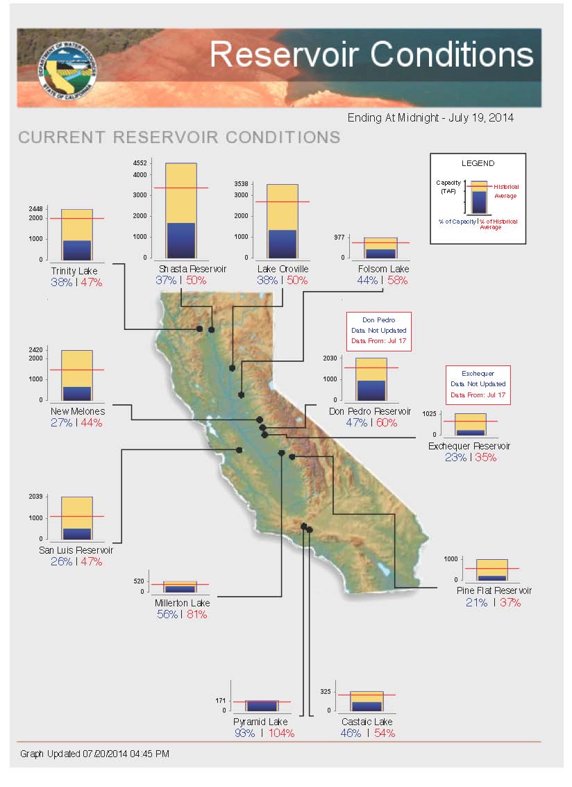
With about 60 percent of California in the midst of exceptional drought what will happen in 2015 will exceed 2013’s category of being the driest year on record.
In making my drought forecast for 2012 and 2013, weather records show that both those years rank California’s top 10 warmest years on record.
It is my contention that solar year 2014 will be called California’s warmest year on record before the onset of the hot and drier year of 2015.
The high temperatures will exacerbate the multi-year drought with little precipitation that will also affect the Pacific Northwest in 2015.
Spring, Summer & Autumn 2015:
Early Spring & Dry, Very Hot Summer & Fall Seasons

My analysis of astronomic transits for 2015 shows to expect blazing hot conditions that will be experienced after the earlier-than-normal spring that will help farmers get a good start on planting after two successive years of cold wet springs in North America and Europe.
I am forecasting warmer-than-average temperatures for all of 2015 and into 2016 where my calculations show a very late start for winter 2015-2016 that will not begin until late January 2016 with that winter extending well into March of that solar year.
As for the solar year of 2015, it will see some of the hottest temperatures that will break records, also for humidity as well as heat waves will return.
The climate year of 2015 will be, in effect, a kind of ‘double summer’ in the northern hemisphere that will extend deep into autumn 2015 – resulting in a later than normal winter in 2016.
Farmers will be able to grow several bumper crops well into the harvest season of 2015 due to the earlier than normal and warmer than normal spring, the hot summer and warmer than normal Indian summer of fall 2015.

Farmers are therefore advised to prepare for the warmer than normal weather conditions that will give them the ability to make up for the last two wet and cold spring seasons that delayed the planting of spring and summer crops.
Irrigation and management of water flow will be critical in taking advantage of the warmer-than-normal temperatures in 2015 and 2016.

The blazingly hot temperatures – particularly through summer and fall of 2015 – will require advance irrigation methods due to the paucity of precipitation in both solar years of 2015 and 2016.
All of this will be the result of the activity of the Sun, which will cause world temperatures to rise in 2015 and 2016 before the Sun enters its Grand Minimum phase and usher in global cooling, which according to my climate forecast will begin officially in mid-December 2017.
The warm year of 2015 will cause ‘man-made global warming’ alarmists to go on again about something that is quite impossible – and that is man-made global warming as there is no such thing. It cannot exist according to the laws of physics.
It is the Sun that is the cause of both global warming and global cooling and as the solar-forced global warming wanes – it will go out with a bang in solar years 2015 and 2016 with warmer than normal average temperatures, as well as continued drought conditions, especially in regions like the western U.S., and even the Pacific Northwest, where it will be drier than normal in 2015-2016.
The word on 2015 will feature more frequent bursts of warmer-than-average temperatures.
Over the span of both solar years (2015 and 2016) the natural climate oscillation known as the Pacific Decadal Oscillation (PDO) will kick into high gear and we will witness a temporary surge in warmer-than-average temperatures.
This phase is caused by the activity of the Sun relative to the Earth’s atmosphere which is the last hurray of solar-forced global warming.
We are in the transition phase of solar-forced global warming to solar-forced global cooling, which sees both extreme warm and extreme cooler temperatures and weather conditions.
This is evident by the recent colder than normal seasons from the central to eastern regions of North America as opposed to the western, which has been experiencing drier and warmer climate conditions.
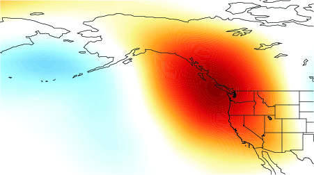
'California’s Drought & A Dry Pacific Northwest'
For instance, the steady ridge of high pressure that has sat just off California’s coastline for well over a year and a half is a sign of this.
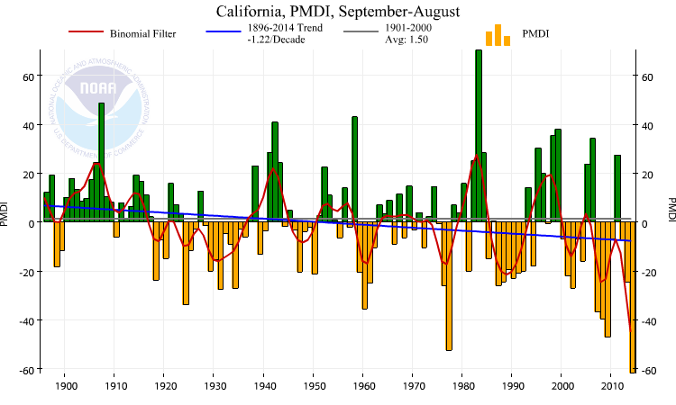
California is undergoing what amounts to a third consecutive year of exceptional drought.

Solar year 2013 was listed as the driest calendar year for California in at least 120 years of record keeping.
What has happened to the jet streams is a flow from west to east that has led to a more meridian zonal flow from north to south. This is also the reason for the polar vortices that have struck from central Canada down into the United States and then leaked eastward.
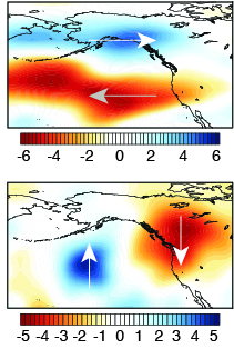
For California, the changes in zonal flow from west-to-east has altered the wind anomalies so the westerly winds that are associated with Pacific storm tracks have changed well to the north of California, Oregon and Washington state, leading to exceptional drought conditions and wildfires.
The rainy season in California takes place from October to May and what should be winter storms during the winter come to the state from the west and northwest with Pacific moisture in rain and snowfall in the mountains. This has not happened for over two solar years.
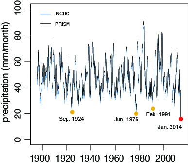
This blocking of storm tracks with precipitation from low pressure systems have not reached California and has resulted in record low rain and snowfall.
My multi-year drought forecast for California means a continuation and intensification of California’s drought in solar years 2015 and 2016.
This ridge will continue to block winter storms from reaching California and much of the Pacific Northwest; which will also continue to yield record-low snow and rainfall along with record-high temperatures.
My forecast is for the very dry and warm conditions to continue and expand in both 2015 and 2016 as both years, according to my climate forecast, are the very last years of solar-forced global warming that began in 1980-81.
'My Forecast Warning on Global Cooling'
With solar years 2015 and 2016 expected by me to be warmer-than-normal and drier than normal climate years; I also expect many people to procrastinate on the larger issue at hand – global cooling.
With the warmer years of 2015 and 2016 on the way, it is essential not to mistake the warmer than normal climate conditions for the fallacy of 'man-made global warming' because the warm two solar years ahead will yield to a new climate regime of global cooling, brought on by the Sun's coming Grand Minimum.
I would also like to remind all that the warmest years on record took place in the 1930s in the United States. Those records still stand to this very day.
After the warmer-than-normal and dry climate years of 2015 and 2016 gives way into 2017, expect signs of abrupt phases of cooling to take place as December 2017 approaches.
This is when the Sun will usher in a 36-year period of global cooling. After that, we will see progressively faster colder and wetter conditions in various parts of the world take a firmer hold on the planet into the early years of the 2020s.

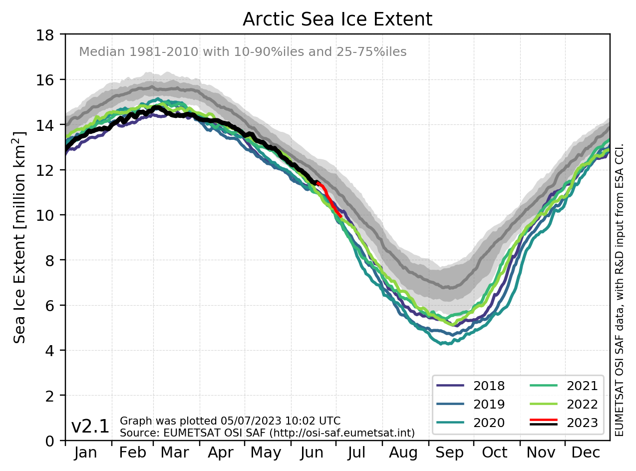
The trending to global cooling has been ongoing since 2001, and the Arctic and Antarctic sea ice extents have been steadily growing and thickening in preparation for the Sun’s Grand Minimum that brings the world the new climate regime of global cooling.
It will be a much colder and wetter world for some regions and a colder and drier world for other regions of the planet.
The worst of it will take place in the decades of the 2020s and 2030s with the onset of a major La Nina I have forecast to take place between 2020 and 2022 that will cause the winter of 2021-2022 to rival the brutal winter of 2013-2014 in both hemispheres.
In forecasting global cooling, I highly recommend that farmers prepare for the abrupt colder and wetter climate conditions during the solar years of 2015 and 2016 in advance of the Sun's coming hibernation phase that I have forecasted will bring in the new climate regime of global cooling as it will surely affect all crop growth and yields over the next 30 years.

There will be much work for farmers to do as thousands of farms – large, medium and small - will have to seriously consider relocating further south due to the onset of global cooling if they want to remain in the business of growing crops.
Those who are unable to relocate further south will have to make serious adjustments to what crops they are able to grow with colder temperatures that will make the winter and spring seasons colder and wetter than normal as well as the summer and fall seasons cooler and cloudier than normal.

The last best years to plan for the new climate regime of global cooling will be during the solar years of 2015 and 2016 to gain the advantage on its official arrival by mid-December 2017.
~ Theodore White, astrometeorologist.Sci
Winter 2014-2015
Spring, Summer & Autumn 2015
‘A Quick Cold Winter, Early Warm Spring & Blazingly Hot & Long Summer & Autumn’
Published: 28 October 2014
Forecast by Theodore White, astrometeorologist.Sci
As we near the winter of 2014 and the solar years of 2015 and 2016, we will experience the last remaining years of solar-forced global warming.
These years – 2015 and 2016 - will be warmer and drier than normal with record setting temperatures before we reach the abrupt climate year of 2017, which will usher in the official start of global cooling.
I continue to remind of my long-range climate forecast for global cooling which I made in the last decade to arrive, officially, by mid-December 2017.
My forecast is that this new climate state will last approximately 36 years and produce some of the worst cold and wet climate conditions the world has seen in modern times during the 2020s, 2030s and 2040s.
My astrometeorological forecasting is complex as I synthesize all the known positions of the planets of our solar system and the Earth relative to the Sun's condition as well as the position of the Barycenter.
I then integrate all these factors into my seasonal climate forecasts as well as long-range climate forecasts.
The trending to global cooling with the Sun’s coming Grand Minimum will usher in a brutally cold and wetter climate for the Earth that should be prepared for well in advance - and time runs short.
As many valuable years have been wasted by nations and their governments on the impossibility of ‘man-made global warming,’ few countries and their populations are prepared for global cooling and will suffer as a result.
For the shorter-term, my general climate forecast for the coming winter of 2014-2015 is as follows:
WINTER 2014-2015:
A cold winter with fewer polar vortices than last winter, snowy, icy, but a shorter winter on tap
According to my calculations, the winter of 2014-2015 will officially begin on December 10, 2014 and will end on February 21, 2015 giving way to an earlier than expected spring that will be warmer than normal.
The Winter of 2014-2015 will be an active winter, but it will be a shorter season according to my calculations.
It will begin in December with earlier than expected snowfalls for major cities from the central to eastern United States and Canada and continue to rage through January 2015 with heavy snows and polar vortex-forced frigid temperatures for the central and eastern regions of North America in January.
Six of the eight models show a wetter than average winter in the East.
Five of the 8 models the National Weather Service uses show a colder than average January to March along the East Coast.
However, into February 2015, according to my forecast, there will be signs that the winter season is on the wane by February, and by mid-February, the winter will come to an end - earlier than normal - and lead immediately into an early and warmer-than-normal spring 2015.
I forecast an early end to winter in late February 2015 with the emergence of an early spring that will yield warmer-than-normal temperatures.
It will lead straight into a hotter-than-normal and dry summer season that will extend deep into autumn 2015 - what I call a super Indian summer in autumn 2015.
After my warnings in 2013 about the coming of global cooling with the trending to the brutal winter of 2013-2014 when all 50 states were affected by a series of polar vortices during that winter.
With it came very cold temperatures, heavy snowfall and icy conditions that froze Niagara Falls, brought the Great Lakes region and the city of Chicago to a standstill with temperatures recorded as low as minus 37 degrees Celsius.
Although the great majority of forecasters are saying that the winter of 2014-2015 will be months long, according to my calculations, the coming winter will be short and will effectively be over by late February/early March 2015.
There will be no repeat of the brutally long winter of 2013-14 and the cold wet spring that followed in 2014.
Due to the astronomic conditions, snow will fall several days before Christmas 2014 over the Central, Great Lakes, Midwestern, to the eastern coast of the United States.
The dates for snowfall I have calculated for the winter months of 2014-2015 are as follows:
December 21,22,23 – snowfall.
January 18,19,20 – snowfall.
Feb. 15,16,17 – snowfall.
The south-central and southeastern states will see temperatures during winter that are below average. However, the extreme conditions of last winter will not be repeated. Moreover, the Midwestern to Southern and Mid-Atlantic regions of the U.S. should prepare for a sweltering solar year of 2015 that will record new records for warm temperatures.
The west coast of North America will continue to experience the drought I forecasted and will have a warm winter that will then extend into the very hot and even drier year of 2015.
California's record-setting drought shall continue and also will intensify in large parts of the state as well as into the Pacific Northwest with Oregon and Washington state experiencing drier and warmer weather conditions in 2015 and 2016.
With about 60 percent of California in the midst of exceptional drought what will happen in 2015 will exceed 2013’s category of being the driest year on record.
In making my drought forecast for 2012 and 2013, weather records show that both those years rank California’s top 10 warmest years on record.
It is my contention that solar year 2014 will be called California’s warmest year on record before the onset of the hot and drier year of 2015.
The high temperatures will exacerbate the multi-year drought with little precipitation that will also affect the Pacific Northwest in 2015.
Spring, Summer & Autumn 2015:
Early Spring & Dry, Very Hot Summer & Fall Seasons
My analysis of astronomic transits for 2015 shows to expect blazing hot conditions that will be experienced after the earlier-than-normal spring that will help farmers get a good start on planting after two successive years of cold wet springs in North America and Europe.
I am forecasting warmer-than-average temperatures for all of 2015 and into 2016 where my calculations show a very late start for winter 2015-2016 that will not begin until late January 2016 with that winter extending well into March of that solar year.
As for the solar year of 2015, it will see some of the hottest temperatures that will break records, also for humidity as well as heat waves will return.
The climate year of 2015 will be, in effect, a kind of ‘double summer’ in the northern hemisphere that will extend deep into autumn 2015 – resulting in a later than normal winter in 2016.
Farmers will be able to grow several bumper crops well into the harvest season of 2015 due to the earlier than normal and warmer than normal spring, the hot summer and warmer than normal Indian summer of fall 2015.
Farmers are therefore advised to prepare for the warmer than normal weather conditions that will give them the ability to make up for the last two wet and cold spring seasons that delayed the planting of spring and summer crops.
Irrigation and management of water flow will be critical in taking advantage of the warmer-than-normal temperatures in 2015 and 2016.
The blazingly hot temperatures – particularly through summer and fall of 2015 – will require advance irrigation methods due to the paucity of precipitation in both solar years of 2015 and 2016.
All of this will be the result of the activity of the Sun, which will cause world temperatures to rise in 2015 and 2016 before the Sun enters its Grand Minimum phase and usher in global cooling, which according to my climate forecast will begin officially in mid-December 2017.
The warm year of 2015 will cause ‘man-made global warming’ alarmists to go on again about something that is quite impossible – and that is man-made global warming as there is no such thing. It cannot exist according to the laws of physics.
It is the Sun that is the cause of both global warming and global cooling and as the solar-forced global warming wanes – it will go out with a bang in solar years 2015 and 2016 with warmer than normal average temperatures, as well as continued drought conditions, especially in regions like the western U.S., and even the Pacific Northwest, where it will be drier than normal in 2015-2016.
The word on 2015 will feature more frequent bursts of warmer-than-average temperatures.
Over the span of both solar years (2015 and 2016) the natural climate oscillation known as the Pacific Decadal Oscillation (PDO) will kick into high gear and we will witness a temporary surge in warmer-than-average temperatures.
This phase is caused by the activity of the Sun relative to the Earth’s atmosphere which is the last hurray of solar-forced global warming.
We are in the transition phase of solar-forced global warming to solar-forced global cooling, which sees both extreme warm and extreme cooler temperatures and weather conditions.
This is evident by the recent colder than normal seasons from the central to eastern regions of North America as opposed to the western, which has been experiencing drier and warmer climate conditions.
'California’s Drought & A Dry Pacific Northwest'
For instance, the steady ridge of high pressure that has sat just off California’s coastline for well over a year and a half is a sign of this.
California is undergoing what amounts to a third consecutive year of exceptional drought.

Solar year 2013 was listed as the driest calendar year for California in at least 120 years of record keeping.
What has happened to the jet streams is a flow from west to east that has led to a more meridian zonal flow from north to south. This is also the reason for the polar vortices that have struck from central Canada down into the United States and then leaked eastward.
For California, the changes in zonal flow from west-to-east has altered the wind anomalies so the westerly winds that are associated with Pacific storm tracks have changed well to the north of California, Oregon and Washington state, leading to exceptional drought conditions and wildfires.
The rainy season in California takes place from October to May and what should be winter storms during the winter come to the state from the west and northwest with Pacific moisture in rain and snowfall in the mountains. This has not happened for over two solar years.
This blocking of storm tracks with precipitation from low pressure systems have not reached California and has resulted in record low rain and snowfall.
My multi-year drought forecast for California means a continuation and intensification of California’s drought in solar years 2015 and 2016.
This ridge will continue to block winter storms from reaching California and much of the Pacific Northwest; which will also continue to yield record-low snow and rainfall along with record-high temperatures.
My forecast is for the very dry and warm conditions to continue and expand in both 2015 and 2016 as both years, according to my climate forecast, are the very last years of solar-forced global warming that began in 1980-81.
'My Forecast Warning on Global Cooling'
With solar years 2015 and 2016 expected by me to be warmer-than-normal and drier than normal climate years; I also expect many people to procrastinate on the larger issue at hand – global cooling.
With the warmer years of 2015 and 2016 on the way, it is essential not to mistake the warmer than normal climate conditions for the fallacy of 'man-made global warming' because the warm two solar years ahead will yield to a new climate regime of global cooling, brought on by the Sun's coming Grand Minimum.
I would also like to remind all that the warmest years on record took place in the 1930s in the United States. Those records still stand to this very day.
After the warmer-than-normal and dry climate years of 2015 and 2016 gives way into 2017, expect signs of abrupt phases of cooling to take place as December 2017 approaches.
This is when the Sun will usher in a 36-year period of global cooling. After that, we will see progressively faster colder and wetter conditions in various parts of the world take a firmer hold on the planet into the early years of the 2020s.
The trending to global cooling has been ongoing since 2001, and the Arctic and Antarctic sea ice extents have been steadily growing and thickening in preparation for the Sun’s Grand Minimum that brings the world the new climate regime of global cooling.
It will be a much colder and wetter world for some regions and a colder and drier world for other regions of the planet.
The worst of it will take place in the decades of the 2020s and 2030s with the onset of a major La Nina I have forecast to take place between 2020 and 2022 that will cause the winter of 2021-2022 to rival the brutal winter of 2013-2014 in both hemispheres.
In forecasting global cooling, I highly recommend that farmers prepare for the abrupt colder and wetter climate conditions during the solar years of 2015 and 2016 in advance of the Sun's coming hibernation phase that I have forecasted will bring in the new climate regime of global cooling as it will surely affect all crop growth and yields over the next 30 years.
There will be much work for farmers to do as thousands of farms – large, medium and small - will have to seriously consider relocating further south due to the onset of global cooling if they want to remain in the business of growing crops.
Those who are unable to relocate further south will have to make serious adjustments to what crops they are able to grow with colder temperatures that will make the winter and spring seasons colder and wetter than normal as well as the summer and fall seasons cooler and cloudier than normal.
The last best years to plan for the new climate regime of global cooling will be during the solar years of 2015 and 2016 to gain the advantage on its official arrival by mid-December 2017.
~ Theodore White, astrometeorologist.Sci