
Post by AstroMet on Jan 21, 2016 18:14:28 GMT
WHAT HAPPENED TO EL NIÑO?
By Theodore White, astrometeorologist.sci
Since 2013, there have been major forecasts for the arrival of EL NIÑO.
Each year from then, in solar years 2014 and 2015, there have been major news headlines featuring 'forecasts' from climate centers like the National Oceanic and Atmospheric Administration (NOAA) for a 'huge,' 'super' and 'monster' El Nino - only to have each of their El Nino forecasts fall apart spectacularly.
Meanwhile, this astrometeorologist has been consistently stating that there will be no El Nino for several more years (mid-2019 in fact) while I've been working and preparing for the major climate event that will rock the Earth - the Sun's coming quiescent phase and the imminent arrival of global cooling.
As I have long said, ENSO is climate change in action and is a decadal climate event.
There is no such thing as ENSO-Neutral. It does not exist and there has not been an El Nino since the last time I forecasted one (2009-2010) which was followed by the La Nina I also forecasted to immediately follow in 2010-2011.
Right now, in January 2016, there are no 'atmospherics' associated with a true El Nino, as I said there would not be in 2014, 2015; despite major climate centers and organizations forecasting one - based on their faulty computer models and projections from their flawed understanding of what constitutes true 'climate change.'
The dissipation of yet another so-called 'monster El Nino' has been nothing more but warmer Pacific SSTs caused by underwater volcanic activity.
But the haste and hurry to forecast an ENSO (all the climatologists at NOAA have never once successfully forecasted an ENSO in advance) has been going down partially due to the severity of California's drought and the desperation for a El Nino-type precipitation event.
However, desperation for a 'El Nino' does not create one. Neither do computer models.
Only the Sun and modulation of the planets can create ENSO.
So, at this time during the winter of 2016 in the northern hemisphere, many are wondering just what happened to the 'monster El Nino' which NOAA/NWS, multiple media outlets, along with climatologists, meteorologists, and tens of thousands of people on weather boards have been pushing for months now.
Consider this from California's 'LA WEEKLY,' dated January 20, 2016
WTF HAPPENED TO EL NIÑO?
Some have predicted that a "Godzilla" El Niño would strike down upon thee with great vengeance and furious anger this winter.
But so far, not so much.
The "hydrological" rainy season that started Oct. 1 has put downtown Los Angeles below average for precipitation this year, according to the National Weather Service.
We've had 3.75 inches of rain downtown from Oct. 1 through yesterday, according to the NWS. Normal for that time is nearly 6 inches (5.98). Even looking at a more traditional "rainfall year," which starts July 1, we're nearly even.
Downtown has seen about 6.5 inches versus a normal amount of 6.27, according to the service. There we're ahead, but only because of unusually heavy summer rains not necessarily associated with a winter El Niño, said NWS meteorologist Joe Sirard.
We did get a freight train of El Niño storms earlier this month, including two fronts that brought significant rain and even flooding to some areas.
But so far Godzilla hasn't really been on the march.
El Niño is a warm-water phenomenon along the equatorial Pacific that opens the door to a subtropical jet stream, which can bring a succession of unusually wet storms to Southern California. Instead of getting our winter weather from the north, as usual, a strong El Niño will hit us with a "pineapple express" jet stream almost directly from the west.
So far that jet stream hasn't been striking us much (with the exception of those two earlier storms).
High pressure, the most common reason we see warm temperatures and offshore winds, has essentially blocked the subtropical jet stream — so far.
"We've had kind of some ridging off the coast that's been causing systems to come down from the north" instead of from the west, Sirard said. "Still, there hasn't been a lot of rain for L.A. County. It's been focused on the Central Coast."
Indeed. But experts aren't ruling out a heavy El Niño rain year — yet.
"Up until this time we can't say El Niño hasn't produced the impact we expect," said Jin-Yi Yu of UC Irvine's Department of Earth Systems. "It's still early to say it didn't bring the expected rainfall."
It's true: Although experts say January through March is prime El Niño turf, the phenomenon has been known to arrive late in years past. March has been particularly ferocious and, in 1998, local mountains had fresh snow into the spring months.
"We have had years with a relatively dry winter with a lot of rain in March," said Amir AghaKouchak, a professor of civil and environmental engineering at UC Irvine. "Still, there is a chance of extreme rainfall in the next two months."
In the near term, forecasters expect the drizzle we received overnight to have moved out completely by this afternoon. It will be replaced by high pressure and temperatures as high as the low 70s in the L.A. basin Thusday, says Sirard.
A similar front will move down the coast Friday night and Saturday morning, bringing with it a 20 percent chance of rain and more high surf, he said.
Then we'll see more warmth through Tuesday, with possible highs in the mid-70s, Sirard said.
For the long term, he said, "We could still have a miracle in March. We got a little ways to go."
Cross your fingers.
Yes, 'cross your fingers' and wait and wait and wait some more.
If anyone will notice, what is being called 'El Nino' is now turning into cooler waters, which is stumping the so-called 'experts' who in 2014 loudly proclaimed an El Nino for that year - which did not arrive.
All the clamor was desperation for El Nino to solve California's ongoing multi year drought, which I had forecasted, and will not end fully until 2019. That is three years from now.
Meanwhile, I had long forecasted that 2015 would be a warmer-than-average solar year, with an Indian summer and generally dry conditions lasting well through autumn and early winter in the northern hemisphere.
I had forecast in 2013-14 that solar year 2015 would be warmer-than-normal across most of the globe. This was due to astronomic conditions, that of the Sun and modulations of the planets.
Those configurations relative to the Earth indicated to me that a long Indian summer would take place through fall and into early winter in the northern hemisphere and it followed that December 2015 was the warmest calendar month on record.
The result was that as solar year 2015 came to a close; those holding the propaganda of ‘man-made global warming’ would seize on the warmer-than-average climate.
The reality is that 2015 was the 'least' of hot years on record in the United States, It ranks in the bottom ten of extended hot weather.
Consider this,
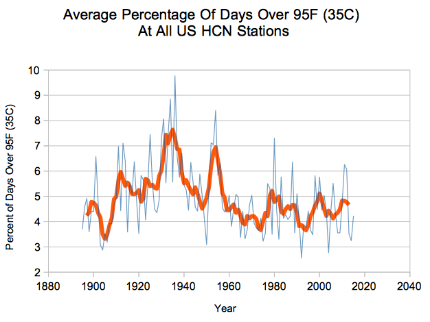
In the 1930s, 90 percent of the U.S. attained 95 degrees Fahrenheit, but in 2015 only 65 percent of continental America reached 95 degrees.
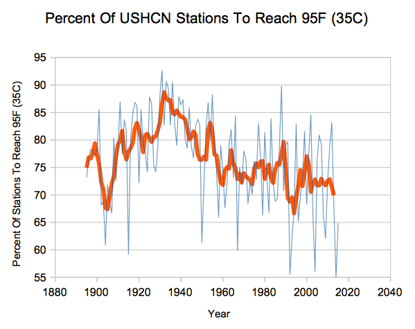
Also 2015, ranked near the bottom in frequency of hot days and that has continued to decline since the hottest decade on record – the 1930s.
So for the National Oceanic and Atmospheric Administration (NOAA) to claim that solar year 2015 was the hottest year is just plain wrong.

Back to the so-called 'monster El Nino' -
We have also heard from the silly Michael Mann of Penn State University who said that a strong El Nino, "like this year's, can add about a third of a degree of warming to Earth's temperature."
As we all know - Michael Mann is not to be believed, or trusted. He also does not forecast. That's because he can't.
Anyway, at this time, a fleet of sensors are being sent into the Pacific to find out why the waters are cooling and why the loudly proclaimed effects of 'El Nino' has not appeared.

The fact of the matter is that what has been seen in the Pacific has been taking place 'under the ocean' and has more to do with the movement of underwater volcanic activity than anything to do with El Nino. The plume that has been seen takes place within the region known as the 'Ring of Fire.'
If you examine the region near and along Peru then you will understand the cause of the section of Pacific rise in temperature.

It is the volcanic activity that caused the plume mistakenly called 'El Nino' for the past two years.

Yet, look at this suite of computer model forecasts from mid-December 2015 through October 2016 for the Niño 3.4 region sea-surface temperature anomaly.

Here is the probabilistic sea surface temperature forecast from the North American Multi-Model Ensemble, made in early May 2015, for the October-November-December 2015 period which all the wild-eyed 'forecasts' and speculations of a monster (and soon to be non-El Nino) call was made:

Those of you who are interested should search for volcanic activity in southwest Peru, both this year and last year and you will discover that the region has been active. It is the cause of the warmer waters in the Pacific that is being mistaken as 'El Nino.'
You will find that approximately 100 miles from the coastlines of Chile and Peru that the region is at full risk from underwater earthquakes and tsunamis due to underwater volcanic activity.
Underwater volcanoes are the reason for the warmer waters, but again, those who push the impossibility of 'man-made global warming' along with the silliness of ENSO-Neutral. There is no such thing.
Again, there will not be an El Nino until mid-2019 and that moderately strong El Nino will last until the year 2020, and which will be followed by a powerful La Nina.
This will be the first ENSO under the new climate regime of global cooling, which begins officially in mid-December 2017.
~ Theodore White, astrometeorologist.Sci
By Theodore White, astrometeorologist.sci
Since 2013, there have been major forecasts for the arrival of EL NIÑO.
Each year from then, in solar years 2014 and 2015, there have been major news headlines featuring 'forecasts' from climate centers like the National Oceanic and Atmospheric Administration (NOAA) for a 'huge,' 'super' and 'monster' El Nino - only to have each of their El Nino forecasts fall apart spectacularly.
Meanwhile, this astrometeorologist has been consistently stating that there will be no El Nino for several more years (mid-2019 in fact) while I've been working and preparing for the major climate event that will rock the Earth - the Sun's coming quiescent phase and the imminent arrival of global cooling.
As I have long said, ENSO is climate change in action and is a decadal climate event.
There is no such thing as ENSO-Neutral. It does not exist and there has not been an El Nino since the last time I forecasted one (2009-2010) which was followed by the La Nina I also forecasted to immediately follow in 2010-2011.
Right now, in January 2016, there are no 'atmospherics' associated with a true El Nino, as I said there would not be in 2014, 2015; despite major climate centers and organizations forecasting one - based on their faulty computer models and projections from their flawed understanding of what constitutes true 'climate change.'
The dissipation of yet another so-called 'monster El Nino' has been nothing more but warmer Pacific SSTs caused by underwater volcanic activity.
But the haste and hurry to forecast an ENSO (all the climatologists at NOAA have never once successfully forecasted an ENSO in advance) has been going down partially due to the severity of California's drought and the desperation for a El Nino-type precipitation event.
However, desperation for a 'El Nino' does not create one. Neither do computer models.
Only the Sun and modulation of the planets can create ENSO.
So, at this time during the winter of 2016 in the northern hemisphere, many are wondering just what happened to the 'monster El Nino' which NOAA/NWS, multiple media outlets, along with climatologists, meteorologists, and tens of thousands of people on weather boards have been pushing for months now.
Consider this from California's 'LA WEEKLY,' dated January 20, 2016
WTF HAPPENED TO EL NIÑO?
Some have predicted that a "Godzilla" El Niño would strike down upon thee with great vengeance and furious anger this winter.
But so far, not so much.
The "hydrological" rainy season that started Oct. 1 has put downtown Los Angeles below average for precipitation this year, according to the National Weather Service.
We've had 3.75 inches of rain downtown from Oct. 1 through yesterday, according to the NWS. Normal for that time is nearly 6 inches (5.98). Even looking at a more traditional "rainfall year," which starts July 1, we're nearly even.
Downtown has seen about 6.5 inches versus a normal amount of 6.27, according to the service. There we're ahead, but only because of unusually heavy summer rains not necessarily associated with a winter El Niño, said NWS meteorologist Joe Sirard.
We did get a freight train of El Niño storms earlier this month, including two fronts that brought significant rain and even flooding to some areas.
But so far Godzilla hasn't really been on the march.
El Niño is a warm-water phenomenon along the equatorial Pacific that opens the door to a subtropical jet stream, which can bring a succession of unusually wet storms to Southern California. Instead of getting our winter weather from the north, as usual, a strong El Niño will hit us with a "pineapple express" jet stream almost directly from the west.
So far that jet stream hasn't been striking us much (with the exception of those two earlier storms).
High pressure, the most common reason we see warm temperatures and offshore winds, has essentially blocked the subtropical jet stream — so far.
"We've had kind of some ridging off the coast that's been causing systems to come down from the north" instead of from the west, Sirard said. "Still, there hasn't been a lot of rain for L.A. County. It's been focused on the Central Coast."
Indeed. But experts aren't ruling out a heavy El Niño rain year — yet.
"Up until this time we can't say El Niño hasn't produced the impact we expect," said Jin-Yi Yu of UC Irvine's Department of Earth Systems. "It's still early to say it didn't bring the expected rainfall."
It's true: Although experts say January through March is prime El Niño turf, the phenomenon has been known to arrive late in years past. March has been particularly ferocious and, in 1998, local mountains had fresh snow into the spring months.
"We have had years with a relatively dry winter with a lot of rain in March," said Amir AghaKouchak, a professor of civil and environmental engineering at UC Irvine. "Still, there is a chance of extreme rainfall in the next two months."
In the near term, forecasters expect the drizzle we received overnight to have moved out completely by this afternoon. It will be replaced by high pressure and temperatures as high as the low 70s in the L.A. basin Thusday, says Sirard.
A similar front will move down the coast Friday night and Saturday morning, bringing with it a 20 percent chance of rain and more high surf, he said.
Then we'll see more warmth through Tuesday, with possible highs in the mid-70s, Sirard said.
For the long term, he said, "We could still have a miracle in March. We got a little ways to go."
Cross your fingers.
Yes, 'cross your fingers' and wait and wait and wait some more.
If anyone will notice, what is being called 'El Nino' is now turning into cooler waters, which is stumping the so-called 'experts' who in 2014 loudly proclaimed an El Nino for that year - which did not arrive.
All the clamor was desperation for El Nino to solve California's ongoing multi year drought, which I had forecasted, and will not end fully until 2019. That is three years from now.
Meanwhile, I had long forecasted that 2015 would be a warmer-than-average solar year, with an Indian summer and generally dry conditions lasting well through autumn and early winter in the northern hemisphere.
I had forecast in 2013-14 that solar year 2015 would be warmer-than-normal across most of the globe. This was due to astronomic conditions, that of the Sun and modulations of the planets.
Those configurations relative to the Earth indicated to me that a long Indian summer would take place through fall and into early winter in the northern hemisphere and it followed that December 2015 was the warmest calendar month on record.
The result was that as solar year 2015 came to a close; those holding the propaganda of ‘man-made global warming’ would seize on the warmer-than-average climate.
The reality is that 2015 was the 'least' of hot years on record in the United States, It ranks in the bottom ten of extended hot weather.
Consider this,
In the 1930s, 90 percent of the U.S. attained 95 degrees Fahrenheit, but in 2015 only 65 percent of continental America reached 95 degrees.
Also 2015, ranked near the bottom in frequency of hot days and that has continued to decline since the hottest decade on record – the 1930s.
So for the National Oceanic and Atmospheric Administration (NOAA) to claim that solar year 2015 was the hottest year is just plain wrong.
Back to the so-called 'monster El Nino' -
We have also heard from the silly Michael Mann of Penn State University who said that a strong El Nino, "like this year's, can add about a third of a degree of warming to Earth's temperature."
As we all know - Michael Mann is not to be believed, or trusted. He also does not forecast. That's because he can't.
Anyway, at this time, a fleet of sensors are being sent into the Pacific to find out why the waters are cooling and why the loudly proclaimed effects of 'El Nino' has not appeared.
The fact of the matter is that what has been seen in the Pacific has been taking place 'under the ocean' and has more to do with the movement of underwater volcanic activity than anything to do with El Nino. The plume that has been seen takes place within the region known as the 'Ring of Fire.'
If you examine the region near and along Peru then you will understand the cause of the section of Pacific rise in temperature.
It is the volcanic activity that caused the plume mistakenly called 'El Nino' for the past two years.
Yet, look at this suite of computer model forecasts from mid-December 2015 through October 2016 for the Niño 3.4 region sea-surface temperature anomaly.
Here is the probabilistic sea surface temperature forecast from the North American Multi-Model Ensemble, made in early May 2015, for the October-November-December 2015 period which all the wild-eyed 'forecasts' and speculations of a monster (and soon to be non-El Nino) call was made:
Those of you who are interested should search for volcanic activity in southwest Peru, both this year and last year and you will discover that the region has been active. It is the cause of the warmer waters in the Pacific that is being mistaken as 'El Nino.'
You will find that approximately 100 miles from the coastlines of Chile and Peru that the region is at full risk from underwater earthquakes and tsunamis due to underwater volcanic activity.
Underwater volcanoes are the reason for the warmer waters, but again, those who push the impossibility of 'man-made global warming' along with the silliness of ENSO-Neutral. There is no such thing.
Again, there will not be an El Nino until mid-2019 and that moderately strong El Nino will last until the year 2020, and which will be followed by a powerful La Nina.
This will be the first ENSO under the new climate regime of global cooling, which begins officially in mid-December 2017.
~ Theodore White, astrometeorologist.Sci


