|
|
Post by Ratty on May 18, 2016 23:06:56 GMT
Lawyers and silt. What can I say?
|
|
|
|
Post by nautonnier on Jun 2, 2016 20:29:34 GMT
|
|
|
|
Post by sigurdur on Jun 3, 2016 2:50:04 GMT
The Pacific is expressing a continuation of -PDO.
|
|
|
|
Post by sigurdur on Jun 3, 2016 2:51:41 GMT
The atmospheric cooling that has started will provide more energy for more intense hurricanes.
|
|
|
|
Post by phydeaux2363 on Jun 3, 2016 11:44:15 GMT
The atmospheric cooling that has started will provide more energy for more intense hurricanes. As should be clear from these threads, a scientist I am not. Can you explain your reasoning, Mr. Sig? I've always believed hurricanes were "heat engines" and so thought cooling would lessen their intensity. Perhaps the bleating of the climateers convinced me of this back in 05, and I shouldn't have listened, although my access to the inter web was limited by a lack of power in my home late in that year! |
|
|
|
Post by nautonnier on Jun 3, 2016 12:17:51 GMT
The atmospheric cooling that has started will provide more energy for more intense hurricanes. As should be clear from these threads, a scientist I am not. Can you explain your reasoning, Mr. Sig? I've always believed hurricanes were "heat engines" and so thought cooling would lessen their intensity. Perhaps the bleating of the climateers convinced me of this back in 05, and I shouldn't have listened, although my access to the inter web was limited by a lack of power in my home late in that year! It is the warm sea under a cool atmosphere that is the problem. The atmosphere close to the surface of the sea which is being warmed by the sun becomes humid due to evaporation humid air is lighter than dry air (H2O molecules have a lower weight than N2 or O2 and due to gas laws take up same space) so the humid air rises even if it is the same temperature as the surrounding dry air. However, the surrounding dry air is cool and has not been warmed up over a warm Pacific on its way East. So the warm wet air rises, the water condenses as it cools with the lapse rate and that adds more heat to the volume of air and presto we have a convective cloud that can become a thunderstorm with sufficient energy from a warm sea. This is called an unstable atmosphere. If several storms are in close proximity all with updrafts of warm wet air, they draw in more air at the surface to replace the air being convected upward. The air being drawn in from all directions will be affected by the Coriolis effect which will result in the winds formed tending to spiral in toward the base of the storms. This spiraling of the winds at the storms base tends to make them move with the spiraling winds eventually if the heat from the underlying ocean is sufficient and the layers of air up to the top of the storms do not have any strong wind shear with wind currents in different directions, a spiraling tropical storm forms sucking air in at its base and out at its tops. Given sufficient heat from the base and 'favorable' upper winds the storm can grow into a hurricane. Due to the Coriolis effect the winds coming from the equator side of the storm that are then forced around the North East quadrant of the spinning storm are the strongest as the storm tends to move slowly North these stronger winds tend to cause the storm to start accelerating to the North East and dependent on the winds most hurricanes will travel slowly westward near the equator then curve North then North East and accelerate back crossing the Atlantic and normally arrive as as deep depression and stormy winds in North West Europe. Of course land and lower ocean surface temperatures can affect that and 'steer' the storm in different directions. |
|
|
|
Post by sigurdur on Jun 3, 2016 12:33:25 GMT
As Naut pointed out it is the contrast in temperature that produces the start of a hurricane. The frequent hurricanes of the 50's thru 80's time period demonstrate this.
|
|
|
|
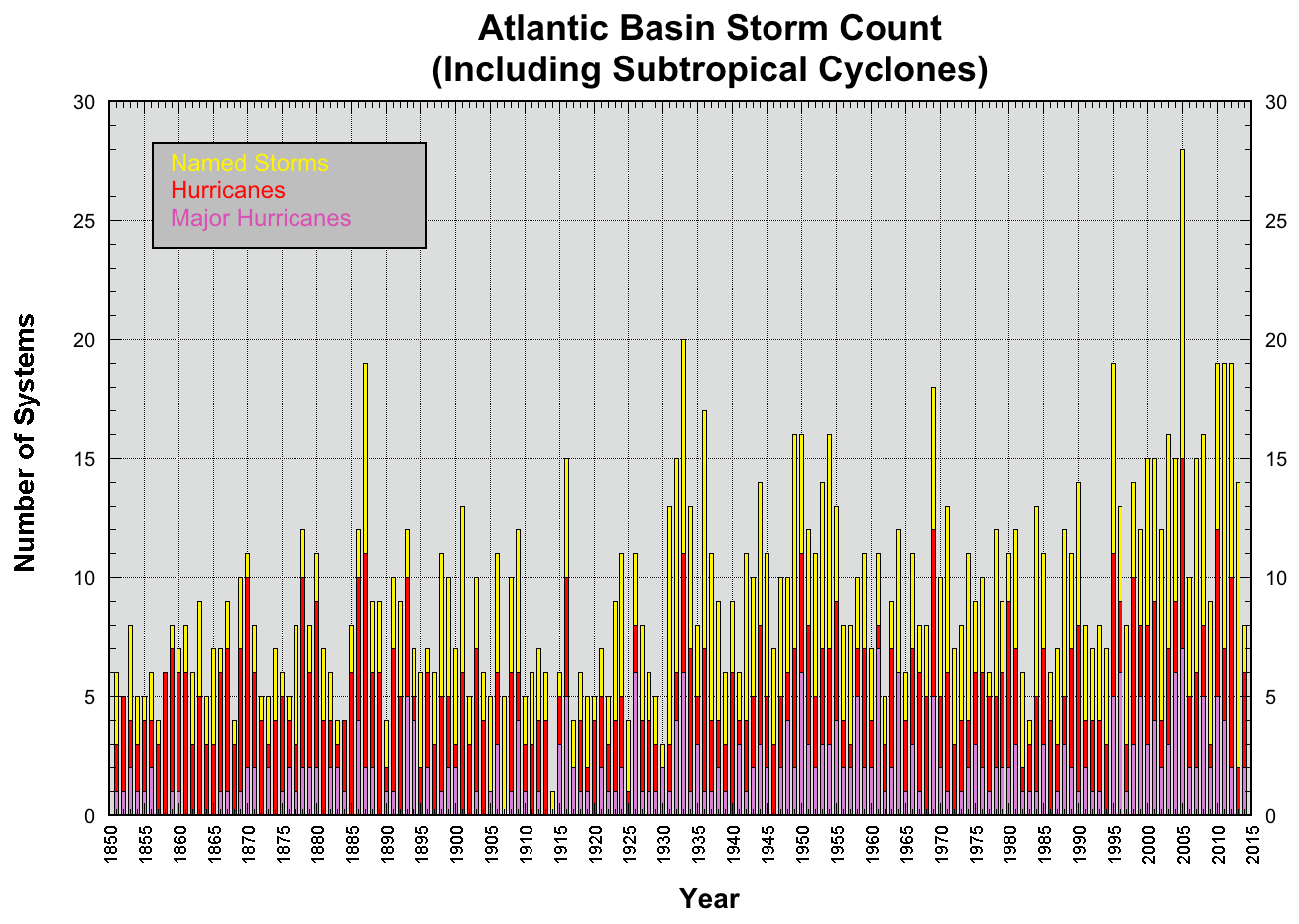
Post by Ratty on Jun 3, 2016 12:54:28 GMT
|
|
|
|
Post by sigurdur on Jun 3, 2016 13:16:26 GMT
The above graph does not fit well with the ACE index. Either Ryan Mue is wrong, or the National Climate Assessment is wrong.
I think I will stick with the ACE index, as that has not been called in question.
|
|
|
|
Post by sigurdur on Jun 3, 2016 13:56:28 GMT
|
|
|
|
Post by acidohm on Jun 3, 2016 18:02:49 GMT
|
|
|
|
Post by nautonnier on Jun 3, 2016 19:53:59 GMT
The break point is around 86F and a suitably unstable atmosphere with no windshear. So the temperatures are just about right and the windshear may be OK now we are at La Nina. However, the temps are not wildly hot. The Gulf of Mexico though is hot and I think that is why Joe Bastardi of Wetherbell is saying the Gulf coast is likely to see more action than the Atlantic coast. |
|
|
|
Post by acidohm on Jun 3, 2016 20:07:27 GMT
The break point is around 86F and a suitably unstable atmosphere with no windshear. So the temperatures are just about right and the windshear may be OK now we are at La Nina. However, the temps are not wildly hot. The Gulf of Mexico though is hot and I think that is why Joe Bastardi of Wetherbell is saying the Gulf coast is likely to see more action than the Atlantic coast. Thankyou, very informative Nautonnier! ! |
|
|
|
Post by nautonnier on Jun 4, 2016 0:21:24 GMT
|
|
|
|
Post by glennkoks on Jun 4, 2016 5:08:34 GMT
In my limited experience wind shear is the key factor. While SST's vary from year to year by the end of June most of the Atlantic breeding grounds for storms is well in excess of the 86F needed to support tropical storm development.
Warm water is the fuel but low wind shear is the spark
|
|