|
|
Post by icefisher on Aug 22, 2017 19:45:45 GMT
Well the NOAA NWS/NCEP/CPC model continues to deepen strongly favoring La Nina at this point. However the weekly update does not update the percentage chances of various conditions on a weekly basis. Those are updated once a month, not by NOAA, but by the academic dominated IRI located at Columbia University. NOAA Model:  IRI All models: (Note: the NOAA model is the royal blue squares showing one of the coldest outcomes) 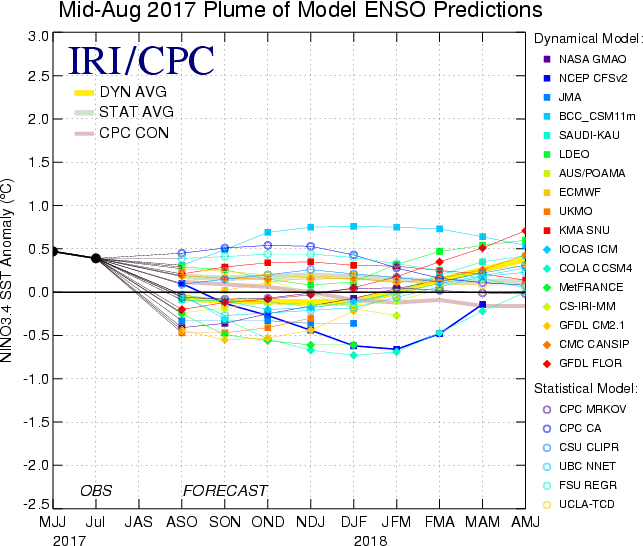 IRI Probabilities: 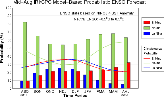 One should also be aware that the IRI spaghetti graph involves more than a couple dozen models, not all of which are updated for each months report and each institution updates information largely on their own schedule which does not always coincide with these reports. |
|
|
|
Post by missouriboy on Aug 22, 2017 19:50:21 GMT
Search enso update and download the NOAA weekly update. There is a large sub surface cold anomaly, all regions but 4 have plummeted to cold anomaly... However NOAA still insisting in 6 months 60% prob of neutral, 20% la n 20% el n. And they've been uncannily accurate so far :! Even a one-armed monkey can go on a roll with that basketball every now and then.  |
|
|
|
ENSO 2017
Aug 22, 2017 20:39:54 GMT
via mobile
Post by acidohm on Aug 22, 2017 20:39:54 GMT
A bit like my apprentices and using their minds....does and can happen... You guys just had an eclipse MOboy...thats pretty rare too!!!  |
|
|
|
Post by missouriboy on Aug 22, 2017 23:45:31 GMT
A bit like my apprentices and using their minds....does and can happen... You guys just had an eclipse MOboy...thats pretty rare too!!! I.m greasing up the wheel chair in prep for its next occurrence in 99 years.  We see it as a divine proclamation of Missouri's right to rule the plains. Substitute lyrics for 'Rule Britannia, Britannia rule the waves'.  |
|
|
|
Post by Ratty on Aug 23, 2017 0:41:10 GMT
Missouri waives the rules?
|
|
|
|
Post by icefisher on Aug 23, 2017 7:07:10 GMT
Search enso update and download the NOAA weekly update. There is a large sub surface cold anomaly, all regions but 4 have plummeted to cold anomaly... However NOAA still insisting in 6 months 60% prob of neutral, 20% la n 20% el n. And they've been uncannily accurate so far :! Even a one-armed monkey can go on a roll with that basketball every now and then. Pretty predictable too. 3 years of warm waters from the major El Nino. As they say even a blind squirrel occasionally finds an acorn. Now its apparent they are doing just about everything to get back to El Nino with IRI/CPC giving 6 times better chance for El Nino by next June than a La Nina. I have to wonder if this is in anyway related to a belief they need a lot more warming to negate the "pause". The past 3 years have breathed life back into global warming observations but they still need a lot more to get back on track and they are heartened by the extended period of El Ninos post the 1997/8 one from 2003 through 2007 but as we have seen that won't help if they can't then avoid another 2008 and 9. |
|
|
|
Post by missouriboy on Aug 23, 2017 16:17:14 GMT
Even a one-armed monkey can go on a roll with that basketball every now and then. Pretty predictable too. 3 years of warm waters from the major El Nino. As they say even a blind squirrel occasionally finds an acorn. Now its apparent they are doing just about everything to get back to El Nino with IRI/CPC giving 6 times better chance for El Nino by next June than a La Nina. I have to wonder if this is in anyway related to a belief they need a lot more warming to negate the "pause". The past 3 years have breathed life back into global warming observations but they still need a lot more to get back on track and they are heartened by the extended period of El Ninos post the 1997/8 one from 2003 through 2007 but as we have seen that won't help if they can't then avoid another 2008 and 9. Unfair comparison. That blind squirrel was provided with a very keen sense of smell. With today's climate science, the only thing left is the smell. Perhaps the next mutation will provide a 'keener' replacement. |
|
|
|
Post by nautonnier on Aug 29, 2017 19:48:42 GMT
I thought I would have a look at the Pacific where the La Nina like cold water is. Normally La Nina is a recharge phase with clear skies allowing the Sun to warm the water whereas El Nino is a discharge phase. So - is it cloudy or clear over the so called Nino boxes in the Pacific. www.ssd.noaa.gov/goes/west/tpac/h5-loop-vis.htmlLooks cloudy to me. |
|
|
|
Post by icefisher on Aug 31, 2017 0:31:28 GMT
Pretty predictable too. 3 years of warm waters from the major El Nino. As they say even a blind squirrel occasionally finds an acorn. Now its apparent they are doing just about everything to get back to El Nino with IRI/CPC giving 6 times better chance for El Nino by next June than a La Nina. I have to wonder if this is in anyway related to a belief they need a lot more warming to negate the "pause". The past 3 years have breathed life back into global warming observations but they still need a lot more to get back on track and they are heartened by the extended period of El Ninos post the 1997/8 one from 2003 through 2007 but as we have seen that won't help if they can't then avoid another 2008 and 9. Unfair comparison. That blind squirrel was provided with a very keen sense of smell. With today's climate science, the only thing left is the smell. Perhaps the next mutation will provide a 'keener' replacement. Your right except the blind squirrel is heavily handicapped by not having only two places to look or smell. What needs to change is the culture. Institutions of higher learning are supported by NOAA and it is where they base their labs. The labs are managed by tenured professors. Modern education is about bringing the slowest students along. There are some labs performing better than others but this is never highlighted. Improving reporting of ENSO prediction could well be aided by a "star" report along side the consensus. I suppose the reason nobody ever thought of that is a combination of entitlement and bringing everybody along at the same pace. . . .and possibly via the fact these groups typically have kind of a "chairman" institution that leads the group. Off the top of my head I would feature maybe 3 institutions in a star report and base inclusion in the star report upon some differing lengths of time for which they had the best prediction records, say 5, 10, and 15 years back, with their runs different colors. I think it would be more informative and serve as a carrot. And since there are groups from other nations in this it might help with the politics too. |
|
|
|
Post by duwayne on Oct 9, 2017 17:37:50 GMT
My lead-in to ENSO posts has usually been that "I don't pretend to be able to predict ENSO". I'm going to be a little braver on this post. If the current ENSO path labelled as 2015 on the chart below follows the paths of the 2 previous ENSOs which started with strong El Ninos, we may well see La Nina readings of less than -0.5 in the weekly ONIs later this year. There is another reason that makes me think a cooling in the Nino3.4 region may be in the offing but I'm going to hold off on discussing that for now.  The numbers on the bottom are the weeks from the first week in January of the year (color) shown. The numbers on the left are the weekly ONIs or ENSO readings. It's been 127 weeks since the 2015 Super El Nino began it's upward swing. After about 127 weeks the 1997 and 2009 ENSOs headed down into the La Nina range. In the above June post I predicted some weekly ONI readings of less than -0.5 in the last half of 2017. A -0.6 weekly ONI was recorded in the weeks of Sept 6 and 13. I haven't updated the above chart here because of the hassle of uploading and posting , but since then the numbers have crept higher, reaching 0.0 last week (Oct 4th) which is week 144 on the chart above. (Note that if plotted, the purple line extension would drop to -0.6 (week 141) and then rise to 0.0 which would coincide with the top of the uptick of the 1997 blue line on week 144.) Both the 1997 and 2009 ENSO ONI's fell from week 144 through week 161 which is the end of January. If the same thing were to happen with the current ENSO we could expect to see a return to La Nina conditions over the next few weeks carrying through January followed by a climb starting at the end of January towards neutral in February of next year. The Governmental agencies' prediction of a likely El Nino in the last half of 2017 have been totally wrong. Their revised forecasts, however, for the next few months are similar to what I have laid out above. So as of now, the super La Nina that I predicted for sometime in the 2007 to 2037 period still could occur in the next year or so, but it will probably require a drop in the AMO. |
|
|
|
Post by duwayne on Oct 10, 2017 2:40:01 GMT
So the odds of cold over 30 years are still there....care to stick your neck out and give us a number, statistically, what those odds might be? Any chance it might be warm..... anytime over those same 30 years? My recent ENSO predictions aren't to be taken too seriously since I haven't spent much time researching my methodology, but I can't do any worse than the governmental organizations. On the other hand I feel pretty comfortable with my prediction that the global temperatures using the UAH6 anomaly will average about 0.18C for the 2007 to 2037 period. This the same as the 2007 trend value based on the 1977 to 2007 period. I anticipate the monthly and annual global temperature volatility with ENSO to be much like the past which will, in my opinion, include a significant temperature decline for a year or two from a super La Nina. |
|
|
|
Post by duwayne on Oct 10, 2017 15:00:48 GMT
18C doesn't sound like global cooling, in fact it sounds a little warmer than our current average? www.temperature.global/Code, I'm not predicting global cooling. That comes from other posters. My prediction is an average UAH6 anomaly of 0.18C (not 18C) over the 2007 to 2037 period. The UAH6 anomalies are based on satellite measurements of the lower atmosphere. The anomaly is the deviation from the average lower atmosphere temperature for 1981 to 2010. The climate scientists have claimed that the lower atmosphere will warm somewhat faster than the earth's surface, so the rate of warming of the lower atmosphere should, if anything, overstate global warming at the surface. The average UAH6 anomaly for 2016 was 0.43C. This was unusually high due to the super El Nino. So far this year the anomaly has fallen to an average of 0.30C as the El Nino effects receded. Note that the El Nino temperature effects drag on a bit after the El Nino is over. |
|
|
|
Post by Ratty on Oct 11, 2017 11:38:03 GMT
Ah...the point . I think i need a bigger font. Thanks for the clarificatioin. Dang! |
|
|
|
Post by Ratty on Oct 24, 2017 23:39:30 GMT
|
|
|
|
ENSO 2017
Oct 24, 2017 23:49:59 GMT
via mobile
Post by sigurdur on Oct 24, 2017 23:49:59 GMT
Why not? Is this another minor ENSO event that won't couple with the atmosphere? |
|


