|
|
Post by tobyglyn on Sept 6, 2018 23:35:37 GMT
So the warmest summer since half a century or so before the end of the little ice age? Very similar to the CET summer record. So summers are warmer now than any time since the generally accepted start of the little ice age! We are doomed, doomed I say  |
|
|
|
Post by Ratty on Sept 7, 2018 0:17:13 GMT
|
|
|
|
Post by missouriboy on Sept 7, 2018 1:40:40 GMT
Very similar to the CET summer record. So summers are warmer now than any time since the generally accepted start of the little ice age! We are doomed, doomed I say Nere to worry ... no doom in the roon. The big green ice machine is making ice aplenty. |
|
|
|
Post by tobyglyn on Sept 7, 2018 4:13:45 GMT
Thanks ratty, very funny |
|
|
|
Post by tobyglyn on Sept 7, 2018 4:14:29 GMT
So summers are warmer now than any time since the generally accepted start of the little ice age! We are doomed, doomed I say Nere to worry ... no doom in the roon. The big green ice machine is making ice aplenty. |
|
|
|
Post by fredzl4dh on Sept 7, 2018 9:52:43 GMT
|
|
|
|
Post by nautonnier on Sept 7, 2018 10:07:56 GMT
It all depends how far you want to go back. Nowadays 'ever' seems to be within the memory of the adolescent cub reporter writing the press release. We are at the cold end of the Holocene each successive dip could see the chaotic climate move to orbit the 'cold attractor' 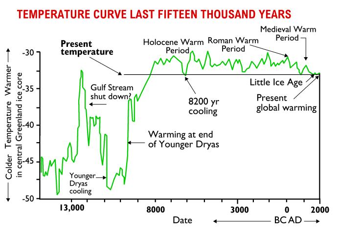 If we go further back than that, you will see that the Holocene is actually an interglacial in an ice age. We are at the cold end of a slightly warmer period in an ice age. 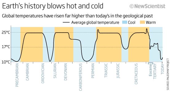 The interesting point to note is the homeostasis during hot periods - the hydrologic cycle ensures that the max temperature is around 25C any disturbance above that recovers back to 25C. As this is a so called 'global temperature' and the tropics are already at the homeostasis limit - the reason for the inter-tropical convergence zone (ITCZ) storms - that 25C means that the temperature of the higher latitudes rises to that of Florida and then stays there apart from occasional excursions higher which are corrected back. These warm periods like the Cretaceous are noted for their explosive growth in different species of plant and animal life. What's not to like?  |
|
|
|
Post by missouriboy on Sept 8, 2018 14:35:52 GMT
Extraordinary wetness from St. Louis to New Jersey. www.weather.gov/Superimpose another hurricane remnant on top of that in the next week could yield some real unpleasantries.  |
|
|
|
Post by nautonnier on Sept 8, 2018 15:25:55 GMT
Extraordinary wetness from St. Louis to New Jersey. www.weather.gov/Superimpose another hurricane remnant on top of that in the next week could yield some real unpleasantries. I don't think St Louis is in much danger from Florence but North Virginia, Maryland, Delaware, Pennsylvania and New Jersey are another matter. All depends on the track and speed of the storm. At the moment it looks like it will be quite a fast blow through. |
|
|
|
Post by nautonnier on Sept 10, 2018 0:19:44 GMT
|
|
|
|
Post by missouriboy on Sept 21, 2018 15:33:24 GMT
Once again the circulation pattern is sending the precipitation south and east of us ... while we are left with the dry high. A pattern that has continued all summer with minor breaks. The chart ABOVE shows that ENSO index seems to be following the trends of 2012-13, whose summer was very similar (hot-dry) here in Middle Earth.  |
|
|
|
Post by Ratty on Sept 25, 2018 12:38:00 GMT
Spring 2018, New Zealand style? Another Polar Blast on course to Bring Freezing Winds and Heavy Snow — Livestock at Risk
NZ, South Island farmers are being warned to prepare as yet another polar blast –possibly the most brutal of the year– edges closer.
MetService is warning that freezing gale force winds and hefty snow accumulations over the next few days could prove deadly for New Zealand livestock.
Meteorologist Georgina Griffiths said the worst weather would arrive late tomorrow, with the freezing wind causing the biggest problems.
“Really, it’s the end of Tuesday and into early Wednesday that we’ll see progressively colder air come up and over New Zealand, and we’re expecting that snow level to really lower over the lower south.”
Southland and Otago were likely to be hardest hit with snow flurries potentially settling down to 200m, and even towards sea level in isolated flurries.
Griffiths said the North Island won’t be spared, with a snow warning for the Desert Road on Tuesday and damaging winds expected in Auckland.
WeatherWatch.co.nz head forecaster Philip Duncan said, “This looks to be one of the more significant southerlies of 2018,” and it comes just a week after NEW ZEALAND FARMERS LOSE 100,000 LAMBS AFTER BRUTAL SPRING STORMS. |
|
|
|
Post by missouriboy on Oct 29, 2018 14:32:36 GMT
What a clown  He picks a single day when we had colder weather in Central Europe in like three months. It's warm again and forecast is horrible. Not that it matters. Half of the country has already turned to desert. Too late to help those dead trees so we may as well have sixth summer month. I have trouble finding any web sites that give me an overview of European climate conditions at any point in time. Do you have any recommendations? Our media doesn't seem to cover such things unless something blows up big time. Hope your drought eases, but American media will only cover it if you literally dry up and blow away ... under the headline of "Trump desicates Central Europe". Found one article that looks at European drought from 1950 to 2012 with some nice charts. www.sciencedirect.com/science/article/pii/S2214581815000026  Some "qualification" from a news organization on the drought in Germany. www.foxnews.com/world/cry-me-a-river-low-water-levels-causing-chaos-in-germanyFrom April through August, a high-pressure zone sat over northern Europe and a low-pressure zone blanketed the south. That created a "blocking situation" that produced the unusual weather, said Freja Vamborg, a senior climate scientist with Copernicus Climate Change Service, a European Union information service.
"During that whole time, most of northern Europe was warm and dry and the Mediterranean was wet," she said.
Most of Germany has been right in the middle of the dry zone. While there has been some relief from the drought in the British Isles and Scandinavia, the drought is still plaguing Germany. |
|


 He picks a single day when we had colder weather in Central Europe in like three months. It's warm again and forecast is horrible. Not that it matters. Half of the country has already turned to desert. Too late to help those dead trees so we may as well have sixth summer month.