|
|
Post by sigurdur on Jun 24, 2013 1:06:50 GMT
icefisher:
Yep....it is.
|
|
|
|
Post by sigurdur on Jun 24, 2013 1:07:22 GMT
The rest of the probability was the sun, CO2 etc.....
|
|
|
|
Post by cuttydyer on Jun 24, 2013 9:29:35 GMT
New paper finds another natural mechanism controlling Arctic sea ice extent A new paper published in the International Journal of Climatology finds 40-79% of the variation in western Arctic sea ice extent is due to natural atmospheric circulation patterns such as the Arctic Dipole (AD), Arctic Oscillation (AO), and Pacific-North American (PNA) pattern. Prior research has shown Arctic sea ice extent is also controlled by natural variation of winds and storm activity, and related to the geography of the Arctic.  Link: onlinelibrary.wiley.com/doi/10.1002/joc.3767/abstractSchtick link: hockeyschtick.blogspot.co.uk/2013/06/new-paper-finds-another-natural.html |
|
|
|
Post by neilhamp on Jun 25, 2013 6:35:47 GMT
Can't quite understand some of the earlier comments regarding sea ice extent
The NSIDC and AMSRE sea ice extent graphs seem to be holding up when compared to previous years
Is some dramatic change about to happen?
|
|
|
|
Post by cuttydyer on Jun 25, 2013 7:46:31 GMT
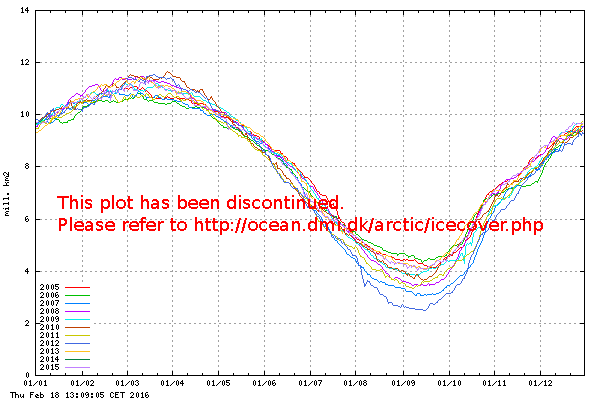
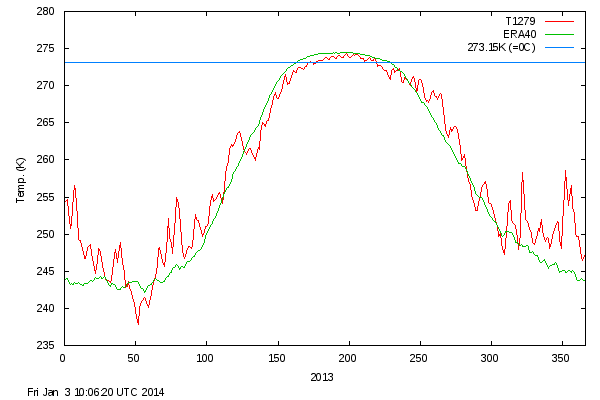
Can't quite understand some of the earlier comments regarding sea ice extent The NSIDC and AMSRE sea ice extent graphs seem to be holding up when compared to previous years Is some dramatic change about to happen? The temperature finally made it to 0°C, but I notice this has dropped below freezing again (the coldest start to a summer as shown in the COI records):  Link: ocean.dmi.dk/arctic/meant80n.uk.phpThe sea ice extent reflects the current temp:  I'm sure this is just the Arctics phoney war phase; catastrophic mega cracking & mega melting must be just around the corner... |
|
|
|
Post by nautonnier on Jun 25, 2013 11:06:46 GMT
If the ice extent surprises all the shamans and stays high, how will the Met Office explain the equatorward jetstreams? After all they were saying that the lack of ice had 'forced' the jetstream south over the UK neglecting the similar equatorward shift of the jetstream in the southern hemisphere around a record level of Antarctic ice.
|
|
|
|
Post by graywolf on Jun 25, 2013 15:38:49 GMT
Don't get to hung up on the 'water side' of the Arctic Naut, there is a lot of land involved in this warm up so look also to 'snow loss' when you think of the Arctic? The high temps across Alaska are now forecast to return at an even higher level ( 95 plus?  ) so that 'lessening' of the temp grad. goes on. Early snow loss is a trend that began in the Late 90's and , as you saw this year, appears to be unconcerned with 'record' snow levels over winter? This 'land temp' also impacts the sea ice (as the loss of sea ice does to land temps?) by taking away the coastal ice which , in it's turn, allows more ice from the Central basin to 'relax' into the open water and melt also. With a central Cyclone pushing all the central basin ice toward the coasts this is a novel way of reducing ice levels without the need for 80N temps to warm at all? This year Nature seems keen on showing all how this works? |
|
|
|
Post by nautonnier on Jun 25, 2013 16:49:03 GMT
Don't get to hung up on the 'water side' of the Arctic Naut, there is a lot of land involved in this warm up so look also to 'snow loss' when you think of the Arctic? The high temps across Alaska are now forecast to return at an even higher level ( 95 plus?  ) so that 'lessening' of the temp grad. goes on. Early snow loss is a trend that began in the Late 90's and , as you saw this year, appears to be unconcerned with 'record' snow levels over winter? This 'land temp' also impacts the sea ice (as the loss of sea ice does to land temps?) by taking away the coastal ice which , in it's turn, allows more ice from the Central basin to 'relax' into the open water and melt also. With a central Cyclone pushing all the central basin ice toward the coasts this is a novel way of reducing ice levels without the need for 80N temps to warm at all? This year Nature seems keen on showing all how this works? "This year Nature seems keen on showing all how this works" Absolutely, you have it in one. A cyclone (blocking high) with another the other side of the Arctic with a looping jetstream in a blocked Rossby wave. So those on one side get unnatural warmth - Alaska and Finland - those on the other colder and wetter Calgary, NW Europe. There is even a possibility of storms running along the jet into the Arctic to break up the ice. It has all happened before. I suspect that sometime in the near future we are going to see a sudden stratospheric warming - a breaking wave - that will also have significant effects with wildly fluctuating temperatures in the far North. It's all weather - it's all happened before and always the climate has swung back the other way as oscillations tend to. |
|
|
|
Post by graywolf on Jun 26, 2013 9:23:40 GMT
Looking at the Jet , over the past couple of weeks esp. , the Atlantic sector seems to be the only portion that looks 'recognisable' with both Polar and Sub tropical in their correct positions? The rest of the globe is mashed and mangled with the Polar jet being replaced ( in it's normal position) by the sub tropical and the polar Jet stuck up beyond 70N?
With the reduction of the gradient between pole and equator there comes a point where we, theoretically, lose the Polar jet completely and the sub tropical Jet moves north to fill the void left by the defunct Polar Jet. This has implications on the climate cells making up the northern hemisphere ( reduced from 3 to 2) and would necessitate a rapid climate shift over many areas oour hemispherere ( rapid expansion north of the 'desert' belt' and a far more violent mixing of 'polar and tropicalair masseses. It would also allow much warmer air masses access to the high latitudes across all of the year impacting ice thickness buincreasingng 'snow fall' over favoured areas.
Are we seeing Nature' flip' into this new state? I am a firm believer that nature tries to hold things in a stable position but if forcing is continuously applied ( and slowly ramped up) there comes a time where She 'flips' into a new quasi stable state?
Continued warming of the planet must bring us to a point where it is easier for her to 'Flip' than to try and maintain old parameters?
|
|
|
|
Post by cuttydyer on Jun 26, 2013 10:01:47 GMT
With the reduction of the gradient between pole and equator there comes a point where we, theoretically, lose the Polar jet With the unseasonably cold Arctic temperatures, how is the thermal gradient currently diminished?  Continued warming of the planet must bring us to a point where it is easier for her to 'Flip' than to try and maintain old parameters? Where is the warming? Both NH & SH temps have been in decline for the last 10 years: HADCRUT3 Northern Hemisphere:  Northern Hemisphere sea temp anom:  HADCRUT3 Southern Hemisphere:  Southern Hemisphere sea temp anom:  This exact pattern of weather was experienced during the last stunted solar cycle (N°20). Extract from Science News Vol.107 (1975), any of the below sound familiar?  "The principal weather change likely to accompany the cooling trend is increased variability-alternating extremes of temperature and precipitation in any given area-which would almost certainly lower average crop yields. The cause of this increased variability can best be seen by examining upper atmosphere wind patterns that accompany cooler climate. During warm periods a "zonal circulation" predominates, in which the prevailing westerly winds of the temperate zones are swept over long distances by a few powerful high and low pressure centers. The result is a more evenly distributed pattern of weather, varying relatively little from month to month or season to season. During cooler climatic periods, however, the high-altitude winds are broken up into irregular cells by weaker and more plentiful pressure centers, causing formation of a "meridional circulation" pattern. These small, weak cells may stagnate over vast areas for many months, bringing unseasonably cold weather on one side and unseasonably warm weather on the other. Droughts and floods become more frequent and may alternate season to season, as they did last year in India. Thus, while the hemisphere as a whole is cooler, individual areas may alternately break temperature and precipitation records at both extremes." "The principal weather change likely to accompany the cooling trend is increased variability-alternating extremes of temperature and precipitation in any given area-which would almost certainly lower average crop yields. The cause of this increased variability can best be seen by examining upper atmosphere wind patterns that accompany cooler climate. During warm periods a "zonal circulation" predominates, in which the prevailing westerly winds of the temperate zones are swept over long distances by a few powerful high and low pressure centers. The result is a more evenly distributed pattern of weather, varying relatively little from month to month or season to season. During cooler climatic periods, however, the high-altitude winds are broken up into irregular cells by weaker and more plentiful pressure centers, causing formation of a "meridional circulation" pattern. These small, weak cells may stagnate over vast areas for many months, bringing unseasonably cold weather on one side and unseasonably warm weather on the other. Droughts and floods become more frequent and may alternate season to season, as they did last year in India. Thus, while the hemisphere as a whole is cooler, individual areas may alternately break temperature and precipitation records at both extremes."Link: www.sciencenews.org/view/download/id/37739/name/CHILLING_POSSIBILITIES |
|
|
|
Post by graywolf on Jun 26, 2013 13:54:41 GMT
What is the relevance of data from 1975? We still had an Arctic in 1075? Ask you cousins in alaska about temps and then pop over to siberia and do the same with your Brothers there?
Looking at the Central pack ( where those 80N temps are closest ) why is the albedo lower than years that showed higher temps from the 'get go'? Could it be that when you mash and mangle ice into small floes ,surrounded by slush, the ocean becomes plainly visible?
I see both hudson and the CA are in full breakup/melt now? The only areas that look 'healthy' are Kara and Beaufort and the OBuoy images appear to tell a similar tale to the ice over the central region?
It is a very interesting season and will go a long way to illustrating just how the Arctic has altered. The more I hear of the low temps and low pressure the more I wonder how folk will expalin as 'natural' ice levels that fall way below 07's old 'record low' that took a 'perfect storm', only 6 years ago, to produce. Should ice remain above 07's record low I will be pleased that we still can hold onto ice and have a little more hope for the future.
Win , win for me really?
|
|
|
|
Post by magellan on Jun 26, 2013 14:54:18 GMT
What is the relevance of data from 1975? We still had an Arctic in 1075? Ask you cousins in alaska about temps and then pop over to siberia and do the same with your Brothers there? Looking at the Central pack ( where those 80N temps are closest ) why is the albedo lower than years that showed higher temps from the 'get go'? Could it be that when you mash and mangle ice into small floes ,surrounded by slush, the ocean becomes plainly visible? I see both hudson and the CA are in full breakup/melt now? The only areas that look 'healthy' are Kara and Beaufort and the OBuoy images appear to tell a similar tale to the ice over the central region? It is a very interesting season and will go a long way to illustrating just how the Arctic has altered. The more I hear of the low temps and low pressure the more I wonder how folk will expalin as 'natural' ice levels that fall way below 07's old 'record low' that took a 'perfect storm', only 6 years ago, to produce. Should ice remain above 07's record low I will be pleased that we still can hold onto ice and have a little more hope for the future. Win , win for me really? Is ice a holy sacrament or something? It's like you folks worship frozen water. It reminds me of the original 'Planet of the Apes' when Taylor discovers the telepathic remaining humans in the Forbidden Zone were kooks worshiping the last nuclear bomb. You actually believe the future is based on how much ice is in the Arctic. Sorry man, that is just a bit on the neurotic edge. |
|
|
|
Post by sigurdur on Jun 26, 2013 18:15:48 GMT
|
|
|
|
Post by nautonnier on Jun 26, 2013 21:48:22 GMT
Looking at the Jet , over the past couple of weeks esp. , the Atlantic sector seems to be the only portion that looks 'recognisable' with both Polar and Sub tropical in their correct positions? The rest of the globe is mashed and mangled with the Polar jet being replaced ( in it's normal position) by the sub tropical and the polar Jet stuck up beyond 70N? With the reduction of the gradient between pole and equator there comes a point where we, theoretically, lose the Polar jet completely and the sub tropical Jet moves north to fill the void left by the defunct Polar Jet. This has implications on the climate cells making up the northern hemisphere ( reduced from 3 to 2) and would necessitate a rapid climate shift over many areas oour hemispherere ( rapid expansion north of the 'desert' belt' and a far more violent mixing of 'polar and tropicalair masseses. It would also allow much warmer air masses access to the high latitudes across all of the year impacting ice thickness buincreasingng 'snow fall' over favoured areas. Are we seeing Nature' flip' into this new state? I am a firm believer that nature tries to hold things in a stable position but if forcing is continuously applied ( and slowly ramped up) there comes a time where She 'flips' into a new quasi stable state? Continued warming of the planet must bring us to a point where it is easier for her to 'Flip' than to try and maintain old parameters? What you are seeing is the effect when the convective cells at the equator become weaker. The jetstreams do not have as much velocity and the Rossby waves start meandering in the way you have described. There is not as much energy in the system. In the mean time warm air makes its way to the poles and cold air to the temperate zones. Almost like watching a top spinning down and wobbling. Nothing whatsoever to do with CO2 and all to do with the Sun. |
|
|
|
Post by icefisher on Jun 27, 2013 5:36:54 GMT
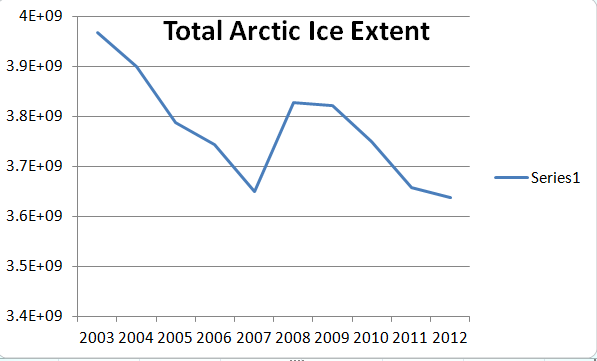
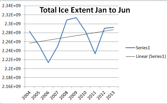
Continued warming of the planet must bring us to a point where it is easier for her to 'Flip' than to try and maintain old parameters? Must? Flip??? Do you have a source for that viewpoint? We continually hear all sorts of non-physical claims for global warming, like more temperature extremes. Its all hogwash. Its just thrown out there to take advantage of ignorance to push a political agenda. Actually just the opposite is far more likely. We all know that on a clear night the surface cools faster and we also know on a clear day the surface also warms faster. Well it makes sense that would apply to the seasons as well. Dry/clear atmosphere means more extreme seasons. The hot seasons get hotter and the cold seasons get colder and that is consistent with the idea that greenhouse gases in fact moderate the climate when the seaons is net warming greenhouse gases slow it down, when the climate is net cooling greenhouse gases slow it down. Fact is everything we are observing is consistent with less greenhouse gas forcing. Here we can see that really ice extent in the Arctic has not changed since 2007. Its flat since then.  Here we can see the "cold" seasons show arctic ice extent rapidly increasing since 2004 essentially in time (one year delay) from when the oceans started cooling.  I mislabeled the above graph it should say: Total Arctic Ice Extent Jan 1 to Jun 25 I mislabeled the above graph it should say: Total Arctic Ice Extent Jan 1 to Jun 25Of course if one has followed this thread, rubbing the worry beads of Thermostat, Numerouno and Graywhale, one would think just the opposite because they are focusing on the greater variability of the seasons and only focusing on the warm seasons. So with 6 years into a flat ice extent (despite all the worry bead folks telling us thinner ice is more fragile ice) we can see that the colder winters are eliminating the warmer summers and ice is flat like temperatures. Prominent in the data is the apparent effect of ENSO. 2007-9 was La Nina, 2010-11 was El Nino. p.s. source is Jaxa Ice data. Metric is the annual total of daily ice extents for the periods displayed. (note: I accounted for a small amount of missing information, I dealt with that by filling last day measured into the subsequent unmeasured days so that each year would have the same number of days measured.) |
|