|
|
Post by cuttydyer on Jul 18, 2013 8:24:06 GMT
Paper finds Arctic climate & sea ice extent related to solar activity:  Multi-decadal variation of the East Greenland Sea-Ice Extent: AD 1500-2000 Multi-decadal variation of the East Greenland Sea-Ice Extent: AD 1500-2000Knud Lassen and Peter Thejll  Solar Cycle Length [SCL] shown by dotted line, Koch sea ice extent index from observations in the Greenland Sea shown by solid line. Abstract: The extent of ice in the North Atlantic varies in time with time scales stretching to centennial, and the cause of these variations is discussed. We consider the Koch ice index which describes the amount of ice sighted from Iceland, in the period 1150 to 1983 AD. This measure of ice extent is a non-linear and curtailed measure of the amount of ice in the Greenland Sea, but gives an overall view of the amounts of ice there through more than 800 years. The length of the series allows insight into the natural variability of ice extent and this understanding can be used to evaluate modern-day variations. Thus we find that the recently reported retreat of the ice in the Greenland Sea may be related to the termination of the so-called Little Ice Age in the early twentieth century. We also look at the approximately 80 year variability of the Koch [sea ice] index and compare it to the similar periodicity found in the solar cycle length, which is a measure of solar activity. A close correlation (R=0.67) of high significance (0.5 % probability of a chance occurrence) is found between the two patterns, suggesting a link from solar activity to the Arctic Ocean climate.
PDF paper link: www.dmi.dk/dmi/sr05-02.pdfSchtick link: hockeyschtick.blogspot.co.uk/2013/07/new-paper-finds-arctic-climate-sea-ice.html |
|
|
|
Post by icefisher on Jul 18, 2013 18:07:34 GMT
Paper finds Arctic climate & sea ice extent related to solar activity: Jim Hansen thinks these sorts of things are just echos of big volcanic explosions. |
|
|
|
Post by graywolf on Jul 20, 2013 21:53:12 GMT
So have we got our chairs pulled up and the popcorn ready for GAC13? We appear to be rapidly honing in on 2012's extent/area for the day and GAC13 looks to be targeting the major area holding onto ice???
With a full 5 weeks with a historical potential for large 'flash melt' is the ice tough enough to do better than it was last year or will we see this storm throw 2013 into pole position for the final few weeks of melt across the basin?
Who'd've thunk it eh? Cold start,slow melt rates and now???
( I'm still looking for the GFS 'cold and wet' forecast for the end of the month btw?...20c in these parts is pretty good for summer...beats 13c and floods I can tell ya!)
|
|
|
|
Post by nautonnier on Jul 21, 2013 0:46:02 GMT
You keep saying that 'I want' something to happen - I am giving you the science of the matter it really does not matter what 'I want'.
1. The water vapor does not emit more energy toward the surface this only occurs if it changes state as it cools. If it absorbs energy then it will not change state as soon.
2. CO2 heated by conduction (collision) with N2 molecules radiates that heat in all directions if it is in the same absorption band as the water vapor then see point 1. Otherwise the radiation is in all directions and most will go to space.
3. Water changing state is not heating anything - it has absorbed and retained the energy _without_ changing its temperature. You appear to be continually confusing heat energy and temperature they are not the same in gases.
4. Convection of water to higher levels in the troposphere is the major heat transport mechanism to space. Radiation only starts carrying more energy after the tropopause. This is not 'what I want' it is the fact of the matter. Radiation in the troposphere is the minor player in transport of heat energy to the tropopause. (there are many NASA papers and research papers that explain this _fact_)
On a humid day the emissions from the surface get absorbed by water without raising the temperature. This is due to the enthalpy of moist air. Moist air is lighter than dry air so will convect upward regardless of heat content. This carries the heat to higher in the atmosphere _without raising temperature_. Heat is NOT temperature in moist air you need to learn about enthalpy - the specific heat if you like of moist air.
|
|
|
|
Post by icefisher on Jul 21, 2013 1:18:36 GMT
You are wanting to bend reality to fit your idea 1. Rising water vapour strongly absorbs energy from the surface and becomes warmer than otherwise and emits more energy that otherwise towards the surface Iceskater your claim: "Rising water vapour strongly absorbs energy from the surface and becomes warmer than otherwise and emits more energy than otherwise towards the surface" does not fit the equilibrium model you have proposed by the molecular screen model The equilibrium target in your molecular screen model for a greenhouse effect is for atmospheric gases to be at a temperature where it radiates half the radiation of the surface. The distance the water vapor is does not matter in accordance with the screen model. At 15C for the surface, the water vapor will be equilibrium only when it cools to -30C. What is warming this water? Its not the surface according to the science you say you ascribe to. |
|
|
|
Post by sigurdur on Jul 21, 2013 3:20:42 GMT
Back radiation has its own thread
|
|
|
|
Post by cuttydyer on Jul 21, 2013 5:39:05 GMT
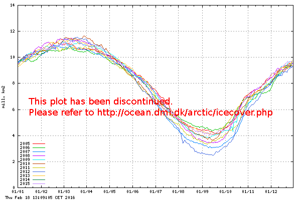
Who'd've thunk it eh? Cold start,slow melt rates and now??? Is it really looking that bad; today's charts:   ( I'm still looking for the GFS 'cold and wet' forecast for the end of the month btw?...20c in these parts is pretty good for summer...beats 13c and floods I can tell ya!) I'm still trying to find a forecast that mirrors your prediction that the heat is here to stay till Winter! As for the GFS forecast showing the jet moving south, it's easy to find:   Link: www.netweather.tv/index.cgi?action=nwdc;sess= |
|
zaphod
Level 3 Rank
  
Posts: 210
|
Post by zaphod on Jul 21, 2013 14:54:58 GMT
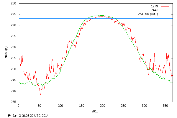
A simple question, which hopefully one of the more knowledgeable members can answer. The DMI Daily Mean Temperatures graph, reproduced by Cuttydyer above and here ocean.dmi.dk/arctic/meant80n.uk.phpshows a pretty regular fluctuation of temperature in terms of time rather than magnitude. It is particularly noticeable in the section of the graph above 273 Kelvin, perhaps because the fluctuations are less wild than elsewhere. I cannot work out the period of the oscillation (is it weekly?) and would like an explanation for the oscillation if someone can give one. Thanks! |
|
|
|
Post by Andrew on Jul 21, 2013 16:54:35 GMT
You keep saying that 'I want' something to happen - I am giving you the science of the matter it really does not matter what 'I want'. 1. The water vapor does not emit more energy toward the surface this only occurs if it changes state as it cools. If it absorbs energy then it will not change state as soon. 2. CO2 heated by conduction (collision) with N2 molecules radiates that heat in all directions if it is in the same absorption band as the water vapor then see point 1. Otherwise the radiation is in all directions and most will go to space. 3. Water changing state is not heating anything - it has absorbed and retained the energy _without_ changing its temperature. You appear to be continually confusing heat energy and temperature they are not the same in gases. 4. Convection of water to higher levels in the troposphere is the major heat transport mechanism to space. Radiation only starts carrying more energy after the tropopause. This is not 'what I want' it is the fact of the matter. Radiation in the troposphere is the minor player in transport of heat energy to the tropopause. (there are many NASA papers and research papers that explain this _fact_) On a humid day the emissions from the surface get absorbed by water without raising the temperature. This is due to the enthalpy of moist air. Moist air is lighter than dry air so will convect upward regardless of heat content. This carries the heat to higher in the atmosphere _without raising temperature_. Heat is NOT temperature in moist air you need to learn about enthalpy - the specific heat if you like of moist air. By definition, on a humid day the moist air is not rapidly rising to high in the atmosphere and is instead close to the surface. I was a glider pilot for many years. Only certain conditions enable transport of warm air to higher altitudes. The best conditions are often in the first few days after a front has gone thru, but quite quickly the air becomes 'stable' and the tendency for rapid thermal creation reduces. To get thermal activity the air has to be 'unstable', particularly if you have a long lasting high, the air becomes 'stable'. Typically in New Zealand away from the sea in summer, it could be as hot as hell at the surface and enormously humid if the ground was damp until about say 10-30am and then the first thermals would begin popping and eventually the air would be significantly less humid and the typical cooling breezes you get with convection would be established. In many parts of the world these humid conditions persist all day long for weeks on end. It is in fact hard for huge masses of air to punch up thru the air above so the surface is often much hotter than you would think possible when we know that hot air and particularly moist air is lighter than dry cold air. But you have a point about the air being colder as it rises. Ultimately however the earth can only cool to space so it does not matter where the radiation to space occurs. The atmosphere cannot directionally channel energy towards space and avoid sending a huge amount of the suns energy back to earth. Either the water releases the energy it receives from the ground via radiation to space and to the surface or it returns to the earth as warmer than it would otherwise be, to warm the surface more than it would do if the air was cooler and had received no radiation You are creating the argument that humidity has little to do with the amount of cooling radiations emitted by the earth that can travel to space. There is though a large body of science that demonstrates the surface is much cooler at night when the air is dry and clear compared to when the air is humid and clear. So you can be seen to be wanting to minimise the impact that radiation has on cooling the surface of the earth 1. It does not matter where the radiations occur, they will enable the earth to be warmer 2. Significant convection is not the automatic result of hot air at the surface. 3. It is well known that in still conditions dry nights are colder at the surface than humid nights and this happens because cooling radiations pass thru the warmer dry air to outerspace. Night cooling systems have been developed for hot dry areas using this very well established principle that connect a houses air con to the radiating surface of the houses roof that are able to send energy to space thru the warm night time dry air. |
|
|
|
Post by phydeaux2363 on Jul 21, 2013 17:33:01 GMT
So have we got our chairs pulled up and the popcorn ready for GAC13? We appear to be rapidly honing in on 2012's extent/area for the day and GAC13 looks to be targeting the major area holding onto ice??? With a full 5 weeks with a historical potential for large 'flash melt' is the ice tough enough to do better than it was last year or will we see this storm throw 2013 into pole position for the final few weeks of melt across the basin? Who'd've thunk it eh? Cold start,slow melt rates and now??? ( I'm still looking for the GFS 'cold and wet' forecast for the end of the month btw?...20c in these parts is pretty good for summer...beats 13c and floods I can tell ya!) |
|
|
|
Post by phydeaux2363 on Jul 21, 2013 17:40:15 GMT
Mr. Wolf, if the disappearance of Arctic sea ice portends catastrophe for humanity, why are you so cavalier, nay positively gleeful, in your posts on the subject? "Popcorn?" "Who'd a thunk it, huh?" Is your being right so important to you that it causes you to ignore what should be to you a very dark side of your forecasts? And why do you always write in interrogatories? Would declarative sentences show too much confidence in your silliness?
|
|
zaphod
Level 3 Rank
  
Posts: 210
|
Post by zaphod on Jul 21, 2013 19:06:46 GMT
Would someone mind answering my question above? I'm trying to learn something...
"A simple question, which hopefully one of the more knowledgeable members can answer.
The DMI Daily Mean Temperatures graph, reproduced by Cuttydyer above and here ocean.dmi.dk/arctic/meant80n.uk.php
shows a pretty regular fluctuation of temperature in terms of time rather than magnitude. It is particularly noticeable
in the section of the graph above 273 Kelvin, perhaps because the fluctuations are less wild than elsewhere. I cannot
work out the period of the oscillation (is it weekly?) and would like an explanation for the oscillation if someone can
give one.
Thanks!"
|
|
|
|
Post by mkelter on Jul 21, 2013 23:52:17 GMT
Would someone mind answering my question above? I'm trying to learn something... "A simple question, which hopefully one of the more knowledgeable members can answer. The DMI Daily Mean Temperatures graph, reproduced by Cuttydyer above and here ocean.dmi.dk/arctic/meant80n.uk.php shows a pretty regular fluctuation of temperature in terms of time rather than magnitude. It is particularly noticeable in the section of the graph above 273 Kelvin, perhaps because the fluctuations are less wild than elsewhere. I cannot work out the period of the oscillation (is it weekly?) and would like an explanation for the oscillation if someone can give one. Thanks!"
You wanted somebody smart. . .I'm not the smartest on this blog but let me give it a stab.
I've watched the DMI graph for several weeks now. The saw-tooth oscillations typically have a frequency of about three days and an amplitude less than 1 degree K.
I'm guessing that the small variation is due to measurement and averaging the temperatures over a very big area every day. The measurements probably come from Roy Spencer's Aqua Satellite program which carries the AIRS Atmospheric Infrared Sounder which measures atmospheric temperature and humidity, land and sea surface temperatures.
AQUA flies leading the satellite formation called the "A Train" consisting of several other satellites (Aura, CALIPSO, CloudSat and the French PARASOL).

Hope this helps. |
|
|
|
Post by icefisher on Jul 22, 2013 0:54:43 GMT
Would someone mind answering my question above? I'm trying to learn something... "A simple question, which hopefully one of the more knowledgeable members can answer. The DMI Daily Mean Temperatures graph, reproduced by Cuttydyer above and here ocean.dmi.dk/arctic/meant80n.uk.php shows a pretty regular fluctuation of temperature in terms of time rather than magnitude. It is particularly noticeable in the section of the graph above 273 Kelvin, perhaps because the fluctuations are less wild than elsewhere. I cannot work out the period of the oscillation (is it weekly?) and would like an explanation for the oscillation if someone can give one. Thanks!" My guess would be its related to the polar vortex. The PV circulates around the arctic at pretty good speed and creates waves of energy much like the Rossby waves that affect the ENSO region. The speed and strength of the vortex varies over the year. Here on the west coast we get temperature fluctuations that take about a week to go a full cycle and its in time with storms that usually feed out of the Aleutian islands. |
|
zaphod
Level 3 Rank
  
Posts: 210
|
Post by zaphod on Jul 22, 2013 0:58:18 GMT
Thanks mkelter, that is certainly an explanation and you are more knowledgeable than me! I'll look into that some more now you've given some background and a direction. I still rate as a beginner where this science is concerned. I must say, I was rather hoping some of the longer standing members would help with this as well as taking constant technical points against each other!! I was looking for some relationship between the ice area fluctuations shown in www.ijis.iarc.uaf.edu/en/home/seaice_extent.htm and the temperature fluctuations, but that is probably far too simple. |
|


