|
|
Post by icefisher on Aug 16, 2014 0:01:00 GMT
More nonsense from NOAA CFS/2 model.  Once each month NOAA extends the black line thus the starting point of a new prediction cycle. The actual model runs are run several times a week. So the predictability window (starting from the end of the solid black line does not change daily but instead monthly). Now for the 4th consecutive month the predictability window points upwards sharply. The ENSO formula in the model pretty much immune to whats happening in the real world has predicted a rapidly building El Nino. Then as observations come in during the ensuing month and new runs are made the model becomes unhinged and the first month begins to decline while the future months seem totally immune to whats happening in the real world. For example when the the predictability window was updated for this June it looked like the graph above. As the month progressed the model becomes unhinged (see below for the archived June results) showing that actual observations focus on the short term while the long term is determined by NOAA academic contractors and are embedded in the model. 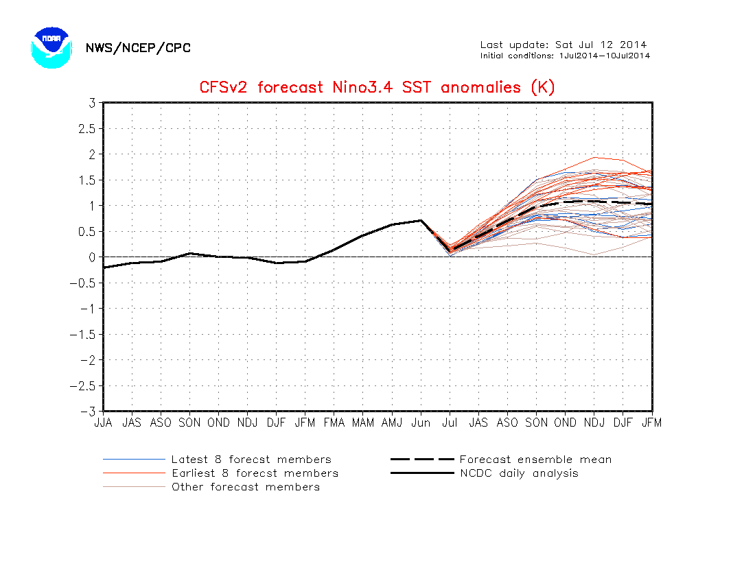 When the monthly update comes it appears observations are completely discarded and suddenly the model line points stiffly upright like a nude J-Law walked into the room. As at the top above and reproduced again below. Getting on in years and being forgetful I take my weekly look at the model results and each month when they do this my first impulse is something changed in the climate. Fact is there is, its the fact we have morons designing NOAA's climate models and they are about as useless as teats on a boar. God forbid what the taxpayer had to pay for this pile of manure. Really the only reason to look at this heap of dung is to remind oneself that the government really should be used sparingly. |
|
|
|
Post by sigurdur on Aug 16, 2014 1:23:45 GMT
Icefisher:
If you want to see something that is really variable, take a look at the 6-10 and 8-14 day forecasts. If the modelers got paid on a reliability probability, they would have starved by now.
|
|
|
|
Post by cuttydyer on Aug 27, 2014 14:45:46 GMT
|
|
|
|
Post by nautonnier on Aug 27, 2014 15:03:47 GMT
And note no apologies from the people talking up this years El Nino, they are all sidling off whistling through their teeth hoping no-one will notice them.
|
|
|
|
Post by cuttydyer on Aug 27, 2014 15:24:14 GMT
And note no apologies from the people talking up this years El Nino, they are all sidling off whistling through their teeth hoping no-one will notice them. I suspect the forecasting failure will be used as justification for more money - or maybe in the future, they'll just make adjustments to the sea surface temperature data sets, fabricating "Super El Ninos" that mirror the output of their models? |
|
|
|
Post by sigurdur on Aug 27, 2014 17:59:57 GMT
|
|
|
|
Post by icefisher on Aug 28, 2014 0:28:14 GMT
And note no apologies from the people talking up this years El Nino, they are all sidling off whistling through their teeth hoping no-one will notice them. I suspect the forecasting failure will be used as justification for more money - or maybe in the future, they'll just make adjustments to the sea surface temperature data sets, fabricating "Super El Ninos" that mirror the output of their models? Of great consternation is the implications of what is happening to the scientific basis for global warming theory. Coupled Climate Models have been attempting to explain the atmospheric pause in global warming. Coupled models are models of atmospheric circulation and ocean circulation. The only location available for this missing heat is the ocean, otherwise its headed on a one way trip to the outer reaches of the universe. Certain models have routinely over the past decade and a half pushed the "consensus" prediction for ENSO to a much warmer level, essentially failing to predict La Ninas routinely and estimating major El Ninos that have gone kaput. The most aggressive predictors of a massively huge El Nino are the climate models most responsible for over predicting the atmospheric effects of CO2. ...Columbia University's COLA CCSM3 model has been absolutely the worst. Of course this model's relationship to James Hansen and Gavin Schmidt probably explains why its the worst. Also Columbia University hosts and chairs the IRI, the organization that writes consensus NOAA ENSO statements also. Of course the most moronic of these scientists keep piling the missing heat into a container they continue to predict will emerge in the near future in a manner far worse than they originally thought. As time and time again as early ocean current change precursors have periodically screamed major El Nino its the atmosphere that is blamed for it not happening. Meaning of course both their ocean models and their atmosphere models are fked up. . . .almost assurdedly for the same reason. . . .namely that CO2 is most likely not warming the atmosphere or the ocean to any significant degree. |
|
|
|
Post by phydeaux2363 on Aug 28, 2014 12:05:29 GMT
And note no apologies from the people talking up this years El Nino, they are all sidling off whistling through their teeth hoping no-one will notice them. |
|
|
|
Post by Ufasuperstorm on Sept 8, 2014 17:22:48 GMT
The weekly updated PDF corrected CFSv2 ENSO forecast no longer shows an El Nino. 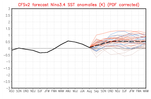  NOAA's monthly update was last week and they lowered El Nino chances once again (albeit from 65% to 60-65%). |
|
|
|
Post by AstroMet on Sept 11, 2014 3:57:44 GMT
I suspect the forecasting failure will be used as justification for more money - or maybe in the future, they'll just make adjustments to the sea surface temperature data sets, fabricating "Super El Ninos" that mirror the output of their models? Of great consternation is the implications of what is happening to the scientific basis for global warming theory. Coupled Climate Models have been attempting to explain the atmospheric pause in global warming. Coupled models are models of atmospheric circulation and ocean circulation. The only location available for this missing heat is the ocean, otherwise its headed on a one way trip to the outer reaches of the universe. Certain models have routinely over the past decade and a half pushed the "consensus" prediction for ENSO to a much warmer level, essentially failing to predict La Ninas routinely and estimating major El Ninos that have gone kaput. The most aggressive predictors of a massively huge El Nino are the climate models most responsible for over predicting the atmospheric effects of CO2. ...Columbia University's COLA CCSM3 model has been absolutely the worst. Of course this model's relationship to James Hansen and Gavin Schmidt probably explains why its the worst. Also Columbia University hosts and chairs the IRI, the organization that writes consensus NOAA ENSO statements also. Of course the most moronic of these scientists keep piling the missing heat into a container they continue to predict will emerge in the near future in a manner far worse than they originally thought. As time and time again as early ocean current change precursors have periodically screamed major El Nino its the atmosphere that is blamed for it not happening. Meaning of course both their ocean models and their atmosphere models are fked up. . . .almost assurdedly for the same reason. . . .namely that CO2 is most likely not warming the atmosphere or the ocean to any significant degree. Totally agree Icefisher. I forecasted that there would be no El Nino this year. Now, I've never been called 'nutty' for my forecasts, except by people who clearly have not a clue how to forecast the climate and weather, but who have plenty of 'nutty' opinions on the climate and weather that never appear in the real world, while I continue to forecast accurately, based on the principles of astronomic forecasting. We've been living in a world of pure bullshit, especially when it comes to 'climate change.' The most basic principles and standard science have been ignored and replaced with ideological bullshit and wishful thinking. But those things do not matter when it comes to the climate and weather here in the real world. Again, according to my forecast, the next ENSO cycle will be a major La Nina that will appear in 2021-2022 and it will be a strong one. We will not see a el Nino for quite some time, rather, the cold oscillation phase of ENSO (La Nina) will dominate for the next three decades. The so-called 'missing heat' is the missing heat that these ideological warmists wish were there (but is not and exists only in their minds and faulty computer models.) As for the computer models: these are run by people who cannot forecast. Though they wish to do just that, one has to learn actually HOW to forecast the climate before doing it in the real world and that is not being done by the current set of 'forecasters' in many climate centers. Their forecasting record is horrid to say the least. The world is getting colder and wetter and colder and drier in various regions. The key word is COLD and again, I continue to forecast, as I have for years now, that the next climate regime coming is global cooling. There is no doubt about it and when it arrives it will change the way that everyone lives. Better be prepared. |
|
|
|
Post by icefisher on Sept 11, 2014 4:47:51 GMT
The so-called 'missing heat' is the missing heat that these ideological warmists wish were there (but is not and exists only in their minds and faulty computer models.) As for the computer models: these are run by people who cannot forecast. Though they wish to do just that, one has to learn actually HOW to forecast the climate before doing it in the real world and that is not being done by the current set of 'forecasters' in many climate centers. Their forecasting record is horrid to say the least. The world is getting colder and wetter and colder and drier in various regions. The key word is COLD and again, I continue to forecast, as I have for years now, that the next climate regime coming is global cooling. There is no doubt about it and when it arrives it will change the way that everyone lives. Better be prepared. It is probably appropriate to recognize that there are two NOAAs. One is the National Oceans and Atmospheric Administration and the other is more like the National Oceans and Atmospheric Apparition. I have great respect for the scientists and researchers that actually make up the civil service, true employee, rank and file of NOAA (the first NOAA). These men and women are fully motivated to make the agency look good. It is perceived what is good for the agency is good for them as NOAA looks good to the public in fulfilling its mission. The people who work under the other NOAA are almost exclusively employees of other organization or are political appointees. They are motivated to make NOAA look bad and divert more funds. Both new funds solicited to fill NOAA weaknesses and old funds devoted to "the wrong Program" into programs these outsiders are representing. This is pure corruption, pure and simple. Its the same sort of corruption that has plagued Washington DC for more than 2 centuries so there is really nothing new about it except its scale in this day and age. A scale that has fluctuated over the last century and a half. Read up on the civil service commission and why it was created, then destroyed, then resurrected and now continues to be toyed with. en.wikipedia.org/wiki/United_States_Civil_Service_CommissionReportedly Al Gore has been one of the worst in history, applying political litmus tests to prospective top positions rather than merit. Could it be because he was one of the biggest controllers of carbon credits in that emerging market? It might actually make some sense to have two NOAAs like above. After all once something is true science you can easily turn it over to the civil service and the government can begin administrating as a result. Only when it is "NOT YET SCIENCE" do you need armies of politically indoctrinated and properly personally motivated academics and researchers to ride herd over the literature and husband the theories. . . .as long as of course you recognize that this is not properly an "administration". So I am interested. It seems that we have this 80 year cycle. Of more interest to our health and safety though seem to be longer term cycles like the LIA and the MWP, cycles of a hundred or more years. I guess at some point Milanovich cycles might play into all this, but beyond 3 decades of cooling do you foresee anything longer term on the horizon, like a continuation of cooling beyond 3 decades, albietly maybe slower for 3 decades to recognize the subsequent 3 decade warm phase, or do you foresee that the modern, post LIA warming is apt to continue after getting through say say cycle 26 or do you see something longer termed like the Maunder Minimum that might signal a new LIA or worse (keeping in mind that perhaps the last LIA may have been made up of a series of three major minimums, the Maunder, the Wolf and the Sporer. 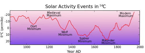 |
|
|
|
Post by Ufasuperstorm on Sept 13, 2014 17:37:39 GMT
Here is the latest prediction from the NOAA/NWS Climate Prediction Center. Roughly an 80% chance of El Nino this winter. cliffmass.blogspot.com/Not sure where he is getting his 80% from as this graph shows only a 65% chance at best. Code, This is a blog post not NOAA. El Niño chances are based on the monthly update and cannot be changed in the weekly update. They are directly based on the IRI Consensus Probabilistic Forecast which coincides with the same day as the monthly update.(The next NOAA probability update is October 9th) The Aussies and Japanese are still calling for a 50 percent chance of an El Niño, whereas NOAA is calling for a 60-65% of an El Niño. (NOAA has decreased chances in the last two monthly updates) And if one does develop they all favor it to be a weak event. ds.data.jma.go.jp/tcc/tcc/products/...no/outlook.htmlwww.elnino.noaa.gov/The JJA ONI value was 0.0 Celsius.  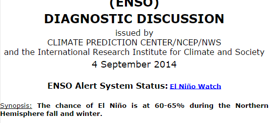 www.cpc.ncep.noaa.gov/products/analysis_monitoring/enso_advisory/ensodisc.html www.cpc.ncep.noaa.gov/products/analysis_monitoring/enso_advisory/ensodisc.html |
|
|
|
Post by duwayne on Sept 13, 2014 19:34:26 GMT
First off, I don’t pretend to be able to predict El Ninos (or La Ninas). There are lots of discussions about the causes of El Ninos, but the basics seem to be really pretty simple. Warm surface water sloshes eastward along the equator in the Nino3.4 region replacing cooler surface water. This is caused by a slackening and/or reversal of the prevailing easterly winds. The slosh toward the east is magnified if the water in the west has been “stacked up” by previous abnormally strong easterlies. The warmed water in the east can increase upward convection in the east which reduces the windflow toward the west and adds to the eastward slosh. Much has been written about the importance of Kelvin Waves, but as we saw earlier this year, even a very strong Kelvin Wave doesn’t cause an El Nino since it is a subsurface phenomenon. Some would argue that the Kelvin Wave contributes to El Ninos because of the warmed subsurface water and that may be true to some degree, but the Kelvin Wave also reduces the “stacking” of the water in the west which reduces the driving force for surface water to slosh towards the east. Last April I noted the increased atmospheric pressures in the western Pacific pushing the wind to east and the existence of water stacking in the west and the slowing of the easterlies. I expected an El Nino might follow. But almost immediately afterward, the atmospheric pressures changed, the western anomalies subsided and a Kelvin Wave leveled the surface waters. There was some slight warming, but no El Nino. Recently, the driving forces for an El Nino are returning. The atmospheric pressures as measured by the BOM SOI are working to slow the prevailing easterlies. However, I do note that the NOAA equatorial SOI which doesn’t provide daily updates was neutral in August. There is a little water stacked in the west. And the winds have currently died down in the western Pacific as seen on this link . The wind anomalies as shown by the large arrows on the bottom chart below are currently favoring some sloshing of warmer surface water to the east but it is limited because of the minimal water stacking in the west.  I’m not predicting an El Nino since I cannot predict the wind, but for the first time since April there are signs that a small El Nino could be under way. |
|
|
|
Post by douglavers on Sept 14, 2014 4:57:06 GMT
|
|
|
|
Post by graywolf on Sept 14, 2014 13:20:59 GMT
I said further up thread but will repeat again I believe that we will see a 'double whammy' Nino with these near Nino conditions persisting through into next year when , again, we will see the Trades fall light and another larger KW slosh back east, reinforcing the warmth straddling the equator.
It becomes increasingly clear that these record Trades are the thing that is adding into the failure of Nino's. We have seen both forecast Nino's failing to arise and Nino's form yet remain stunted and short lived. To me I see a pattern and that is the lack of atmospheric coupling due to the excessive strength of the trades.
Come the northern winter solstice the sun is at it's farthest from the equator plus over and ocean dominated hemisphere. The temp imbalance between tropical Atlantic and Pacific falls to its lowest value for the year and the trades slacken. We see all the water that the trades no longer hold back slosh East but only in time for the Sun to again begin to increase the imbalance as it travels back North. By July the trades are back to supercharged and so no atmospheric coupling can take place.
With a warm ribbon already in place ( and global temps responding) the Jan/Mar 'slosh back' of the warm pool serves to boost any near nino/weak Nino into moderate Nino territory well before the sun again impacts the two basins with its maximum strength and so the atmosphere then couples to the event and we see more WWB's and more water head East from the inflated warm pool in the west Pacific.
Sadly it does not stop there. We already see PDO responding to changes and any long term ( 12 month?) disruption to the trades may drive a flip in the IPO leading to enhanced atmospheric warming over the Pacific ( so ending the imbalance) which , in its turn further reinforces the PDO positive.
Currently we are 1 hurricane away, in the eastern Pacific ,to setting a record for them over any season so patterns already appear to be 'altered'. Any look at the synoptics over the summer Arctic these past two years will also highlight change there, the same with the pressure over Greenland or the weather over the US. Since 2012 global weather appears to have 'shifted' and so different areas are seeing different forcings ( we lost our washout summers here in the UK! ...Huzzah!) so could this 'shift' have subtly altered the forcings that gave rise to the enhanced trades and all that comes with that change? I believe we are about to find out!!!
|
|


