|
|
Post by missouriboy on Sept 20, 2019 16:49:30 GMT
Me thinks that their data time series is not long enough to be using big words like "unprecedented". But of course, they know that. Or their science club card should be taken away.
|
|
|
|
Post by missouriboy on Sept 21, 2019 17:53:00 GMT
I was intrigued by the images and so I had to post the link, I was wondering if there is some explanation other than the world is coming to an end. Big periodic longitudinal loops in the planet's fluid and gaseous circulation system? |
|
|
|
Post by missouriboy on Jan 30, 2021 19:16:24 GMT
Long time no see this thread, so it's on again' Ran across this Dr Roy Spencer article (from 2008) regarding the effects of the PDO cycle on cloudiness and, by definition, temperatures. Worth a re-read. Global Warming as a Natural Response to Cloud Changes Associated with the Pacific Decadal Oscillation (PDO)www.drroyspencer.com/research-articles/global-warming-as-a-natural-response/This ENSO - PDO graph shows the two to be very closely correlated. As the PDO heads deeper into its negative phase, expect greater cloud cover and lower temperatures ... reinforcing an overall decline in the strength of upcoming El Ninos with the lower solar cycle 25. As Jackie Gleason used to say ... "And away we go!"    |
|
|
|
Post by sigurdur on Jan 31, 2021 2:58:11 GMT
Crap. Another cold spring!
|
|
|
|
Post by nautonnier on Feb 2, 2021 18:12:18 GMT
|
|
|
|
Post by nautonnier on Feb 2, 2021 18:20:12 GMT
|
|
|
|
Post by missouriboy on Feb 2, 2021 19:15:35 GMT
Region 3 has been warming for some time, while region 4 just made a tentative turn upward. We will see if it holds. Both are moving in the historical pattern. But something strange is afoot (see map below). Earlier, the primary cold plume was coming from the south Pacific and warmer waters were backfilling the Nino3 area, resulting in the early warming seen in the chart. Problem of fixed boxes. But this new NE cold plume is strange, and might change the trend of the regions if it backfills the fixed boxes. Might yet see a non-standard return sronger negative anomalies. AND the western warm pool is not currently returning to the highs of previous cycles. One and a tenth lower solar cycles may be taking its toll. Expect cooler water pumped eastward during upcoming Ninos. AND since tropical and global temperatures follow ENSO, we don't need a big imagination to bet on what will likely happen. That big red plume heading on an unusually southern NE track may be the remnants of the warm pool buring off into the atmosphere. BETs on whether that will become less red in the future. The ocean is homogenizing toward a cooler state. I don't think that positive PDO is coming back in any strength for the forseeable future. Peikko gets my hedge. 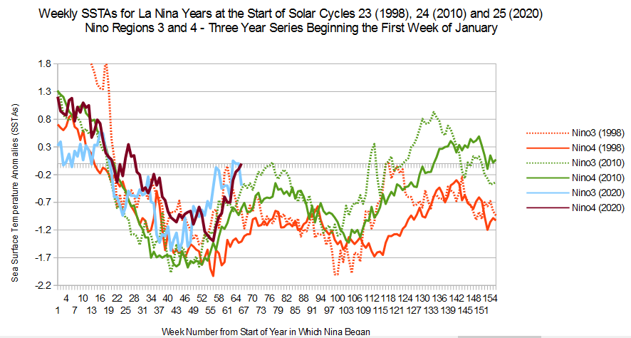  |
|
|
|
Post by acidohm on Feb 14, 2021 21:31:03 GMT
Region 3 has been warming for some time, while region 4 just made a tentative turn upward. We will see if it holds. Both are moving in the historical pattern. But something strange is afoot (see map below). Earlier, the primary cold plume was coming from the south Pacific and warmer waters were backfilling the Nino3 area, resulting in the early warming seen in the chart. Problem of fixed boxes. But this new NE cold plume is strange, and might change the trend of the regions if it backfills the fixed boxes. Might yet see a non-standard return sronger negative anomalies. AND the western warm pool is not currently returning to the highs of previous cycles. One and a tenth lower solar cycles may be taking its toll. Expect cooler water pumped eastward during upcoming Ninos. AND since tropical and global temperatures follow ENSO, we don't need a big imagination to bet on what will likely happen. That big red plume heading on an unusually southern NE track may be the remnants of the warm pool buring off into the atmosphere. BETs on whether that will become less red in the future. The ocean is homogenizing toward a cooler state. I don't think that positive PDO is coming back in any strength for the forseeable future. Peikko gets my hedge. Really eloquent graph that Mr.Missouri. Very very nice 👍🏻 |
|
|
|
Post by missouriboy on Feb 14, 2021 21:48:28 GMT
Region 3 has been warming for some time, while region 4 just made a tentative turn upward. We will see if it holds. Both are moving in the historical pattern. But something strange is afoot (see map below). Earlier, the primary cold plume was coming from the south Pacific and warmer waters were backfilling the Nino3 area, resulting in the early warming seen in the chart. Problem of fixed boxes. But this new NE cold plume is strange, and might change the trend of the regions if it backfills the fixed boxes. Might yet see a non-standard return sronger negative anomalies. AND the western warm pool is not currently returning to the highs of previous cycles. One and a tenth lower solar cycles may be taking its toll. Expect cooler water pumped eastward during upcoming Ninos. AND since tropical and global temperatures follow ENSO, we don't need a big imagination to bet on what will likely happen. That big red plume heading on an unusually southern NE track may be the remnants of the warm pool buring off into the atmosphere. BETs on whether that will become less red in the future. The ocean is homogenizing toward a cooler state. I don't think that positive PDO is coming back in any strength for the forseeable future. Peikko gets my hedge. Really eloquent graph that Mr.Missouri. Very very nice 👍🏻 Thank you.  |
|
|
|
Post by duwayne on Feb 15, 2021 18:07:06 GMT
Missouri, are you seeing anything in the ENSO comparisons that might be a consequence of the reduced 24/25 solar cycle?
|
|
|
|
Post by missouriboy on Feb 16, 2021 4:48:22 GMT
Missouri, are you seeing anything in the ENSO comparisons that might be a consequence of the reduced 24/25 solar cycle? The pre-cycle Nino has been progressively smaller from SC23 to SC24 to SC25. The following Nina for SC24 was on average, shorter and warmer than the Nina for SC23. The SC25 Nina so far appears slightly warmer than SC24, but is following the same general trend. Hard to tell at the moment, as our sample is only three. |
|
|
|
Post by duwayne on Feb 16, 2021 18:56:09 GMT
Missouri, are you seeing anything in the ENSO comparisons that might be a consequence of the reduced 24/25 solar cycle? The pre-cycle Nino has been progressively smaller from SC23 to SC24 to SC25. The following Nina for SC24 was on average, shorter and warmer than the Nina for SC23. The SC25 Nina so far appears slightly warmer than SC24, but is following the same general trend. Hard to tell at the moment, as our sample is only three. What follows is not a prediction. Missouri, in early 2020, based on the history of ENSO and the solar cycle, a La Nina seemed like a good possibility in 2020 or 2021. I wasn’t totally convinced it would happen in 2020 because the strong El Nino which had preceded the La Ninas in 2010 and 1998 was missing. I thought 2021 might be the better possibility. As it turned out your prediction was correct and there was/is a strong La Nina which began in 2020. So far it has been weaker than its 2 predecessors and there’s not much indication that the weaker solar cycles are driving a stronger La Nina. But, there’s possibly more to come. The 2 predecessors showed a second La Nina downturn leg albeit weaker than the first. Is it possible the “big one” could happen in 2020/2021? Does it require a weakening in the La Nina in the next several weeks to build up a “sling shot” approach to a super La Nina? This is not a prediction. |
|
|
|
Post by missouriboy on Feb 17, 2021 0:13:34 GMT
The pre-cycle Nino has been progressively smaller from SC23 to SC24 to SC25. The following Nina for SC24 was on average, shorter and warmer than the Nina for SC23. The SC25 Nina so far appears slightly warmer than SC24, but is following the same general trend. Hard to tell at the moment, as our sample is only three. What follows is not a prediction. Missouri, in early 2020, based on the history of ENSO and the solar cycle, a La Nina seemed like a good possibility in 2020 or 2021. I wasn’t totally convinced it would happen in 2020 because the strong El Nino which had preceded the La Ninas in 2010 and 1998 was missing. I thought 2021 might be the better possibility. As it turned out your prediction was correct and there was/is a strong La Nina which began in 2020. So far it has been weaker than its 2 predecessors and there’s not much indication that the weaker solar cycles are driving a stronger La Nina. But, there’s possibly more to come. The 2 predecessors showed a second La Nina downturn leg albeit weaker than the first. Is it possible the “big one” could happen in 2020/2021? Does it require a weakening in the La Nina in the next several weeks to build up a “sling shot” approach to a super La Nina? This is not a prediction. I'll attach some previous charts for comparison. On chart #2 below you will note that 5-year runing ENSO averages shows net positive ENSO values across big cycles 21 and 22. These were net negative during cycles 19-20 and have done so again across cycles 23 and 24. Little doubt that will agian be the case for cycle 25, unless something changes. This has been a brutal February, not just here, but across most of the Northern Hemisphere. Nina in combination with the sudden stratospheric warming event have wrought havic. The following is conjecture. I am not sure that we really know what drives the coldness and length of La Nina. We know that there is a radical pressure change just prior to the onset of a new solar cycle which causes the trades to die down and allows warm water to pulse eastward. As atmospheric pressure changes at the end of the Nino phase, the trade winds kick in (a reverse in pressure) and Nino wanes into Nina, with colder water replacing warmer in the Eastern Pacific. The Nina phase seems to last ~2 years with a warming break in the Northern Hemisphere summer. The heating may be a combination of upwelling and solar surface heating. We don't know why the 2010-11 Mid-Nina warmer phase and the second Nina cold phase were warmer than those associated with the 1998-99 Nina. We don't know where the 2020-21 La Nina is going, except it has repeated the first downward phase at a slightly warmer level, and appears to be entering the mid-cycle warming phase. I think we will have to wait. 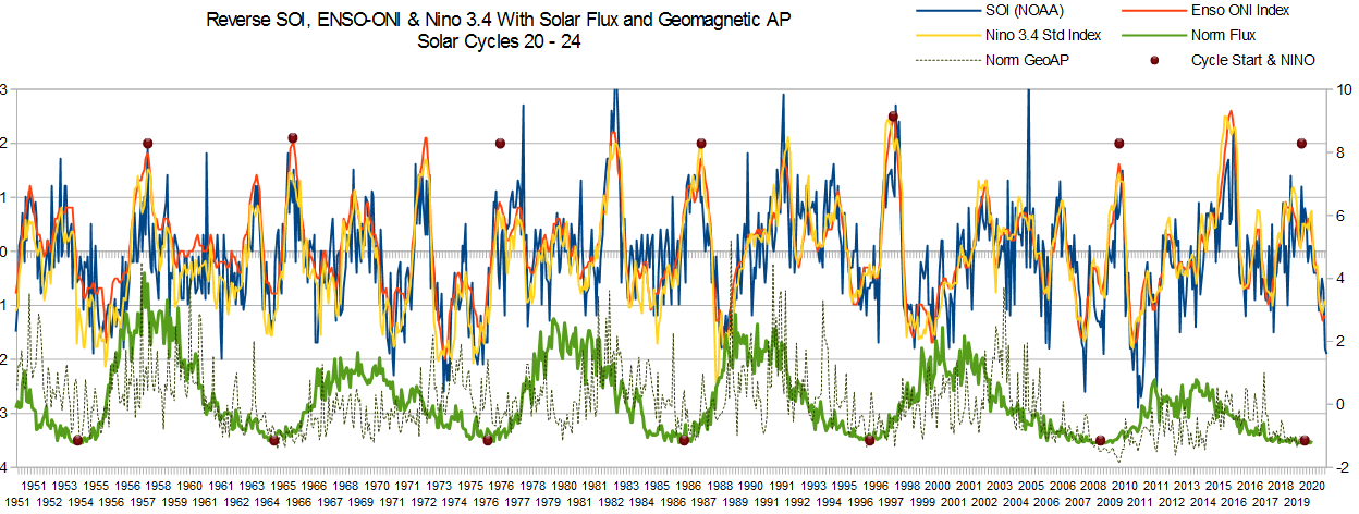 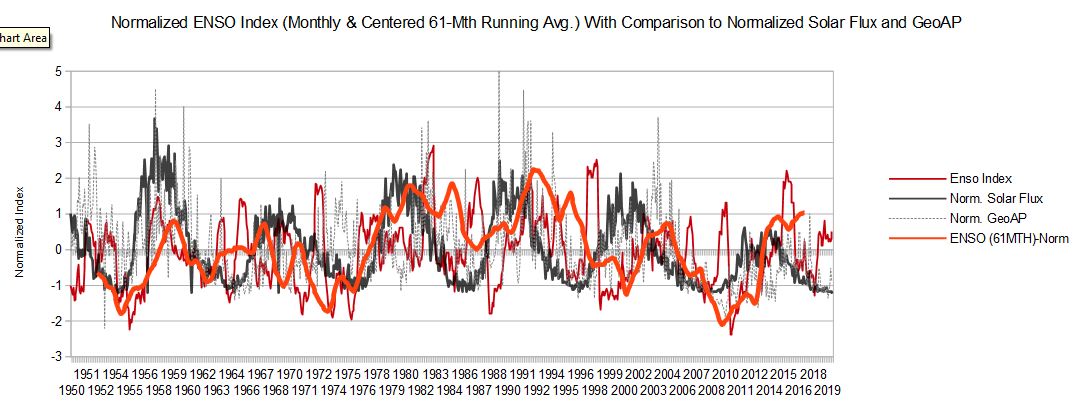 |
|
|
|
Post by sigurdur on Feb 17, 2021 2:08:24 GMT
There is a dispute in the models, according to Cornell. 50-50 chance we will slide into a deeper Nina later summer. I think I favor the deeper Nina.
|
|
|
|
Post by acidohm on Mar 30, 2021 17:46:17 GMT
|
|


