|
|
Post by nautonnier on Sept 19, 2017 17:14:56 GMT
Fujiwara anyone?  As shown in an earlier post a European model is expecting Maria to catch up with Jose and then the resulting rotation of the two about each other (resembling the Japanese dance the Fujiwara) may slingshot Jose into the NE coast. |
|
|
|
Post by duwayne on Sept 19, 2017 18:34:07 GMT
I'm seeing explanations of latent heat as requiring an understanding between kinetic and potential energy. I get that when a water molecule gets energised enough at boiling point (potential energy??) It vaporizes at a much higher energy level (kinetic energy?) Doesn't explain however, evaporation at earths surface temps which requires 100°c? Photon energy from ir concentrated in surface of h20?? Does explain how an h20 molecule reducing excitivity through condensation releases the energy it required to be a gas.... Acidohm, from what you've read would you agree with the following "layman-friendly" statement... A water molecule grabs an extensive amount heat from its surroundings as it is turning from a liquid into vapor and it "hides" that heat so you don’t see any outward signs that it is present while it is a gas. The water vapor molecule can then “float” up into the atmosphere and condense into a water droplet. In so doing it will release its load of hidden heat (latent heat) which results in warming of the surrounding air. |
|
|
|
Post by nautonnier on Sept 19, 2017 19:01:19 GMT
I'm seeing explanations of latent heat as requiring an understanding between kinetic and potential energy. I get that when a water molecule gets energised enough at boiling point (potential energy??) It vaporizes at a much higher energy level (kinetic energy?) Doesn't explain however, evaporation at earths surface temps which requires 100°c? Photon energy from ir concentrated in surface of h20?? Does explain how an h20 molecule reducing excitivity through condensation releases the energy it required to be a gas.... Acidohm, from what you've read would you agree with the following "layman-friendly" statement... A water molecule grabs an extensive amount heat from its surroundings as it is turning from a liquid into vapor and it "hides" that heat so you don’t see any outward signs that it is present while it is a gas. The water vapor molecule can then “float” up into the atmosphere and condense into a water droplet. In so doing it will release its load of hidden heat (latent heat) which results in warming of the surrounding air. Hi Duwayne I have started a latent heat thread if you want to repost over there - Acid has already added stuff to it. I agree completely with your statement - just would like to know how the water molecule does it. |
|
|
|
Post by glennkoks on Sept 20, 2017 3:02:31 GMT
Update post Harvey day 23...
Once again I would like to thank everyone for the support. The last 3 weeks have been a blur. There has been an overwhelming amount of help and support from neighbors, friends and even complete strangers. The first three days were spent emptying the contents of my home into a huge pile on the curb, tearing out carpet, drywall and insulation up to the 4' mark. The next 11 days were spent de-humidifying my home.
The rebuilding process is going well. Drywall is about 90% replaced and the tape and floating process has begun. "Hoping" to move back in by Halloween...
As for the storm details. Rain started falling on Friday, August 29th as the outer bands of Harvey passed through. Saturday evening at about sunset all hell broke lose. Rain came down in buckets and did not stop until Tuesday afternoon. Storm totals in my home town of Friendswood, TX were officially 51.8 inches for the five day total. Over a year worth of rain. Bayou's, creeks and rivers all crested and poured over. Over 3000 homes were flooded in my town alone.
As bad as this storm was it was certainly not unprecedented. Amelia in 1978 dumped 48" of rain over parts of Texas. Claudette in 1979 dumped 42" in 24 hours on Alvin, Tx. (still the one day highest rain total in the lower 48) and Allison in 2003 dumped 35+ over a widespread area of Southeast Texas. So it seems we have had four 100 year floods since 1978. Perhaps these extreme rainfall events from stalling tropical storms are a little more common than the USGS thinks they are.
I will try to get more pictures posted of the aftermath as time permits.
|
|
|
|
Post by douglavers on Sept 20, 2017 4:44:23 GMT
"Doesn't explain however, evaporation at earths surface temps which requires 100°c?"
Water does not require 100degC to evaporate. My shirts dry well at room temperature!!
Also the solid form of water has a significant vapor pressure. Left on its own at -1degC, it will slowly disappear.
That is what was happening to the glaciers on Mt Kilimanjaro, where it is permanently below freezing. Not enough snow to maintain the glaciers [but I don't know what has happened recently].
|
|
|
|
Post by sigurdur on Sept 21, 2017 11:40:42 GMT
|
|
|
|
Post by phydeaux2363 on Sept 21, 2017 15:13:42 GMT
Thanks for this, Mr. Sig. For some reason I haven't been able to access this page since Dr. Maue moved to Weatherbell. I've got it bookmarked now.
So even with the active N. Atlantic season about which so much breathless commentary has been generated, global ACE is 89% of "Normal." (I hate that word in climate and weather discussions, but the fact that Dr. Maue uses it means I must be missing something). My guess is you won't be hearing about that percentage in the media.
Ms. Nature spreads her storms around the various basins from year to year, but in the end seems to use tropical cyclones to transfer pretty much a constant amount of energy from the tropics to the mid and upper latitudes year after year. You'd almost think it was one small part of a very complex, non-linear, chaotic system that is impossible to model. But then I am not a "climate scientist."
|
|
|
|
Post by phydeaux2363 on Sept 21, 2017 15:15:40 GMT
Update post Harvey day 23... Once again I would like to thank everyone for the support. The last 3 weeks have been a blur. There has been an overwhelming amount of help and support from neighbors, friends and even complete strangers. The first three days were spent emptying the contents of my home into a huge pile on the curb, tearing out carpet, drywall and insulation up to the 4' mark. The next 11 days were spent de-humidifying my home. The rebuilding process is going well. Drywall is about 90% replaced and the tape and floating process has begun. "Hoping" to move back in by Halloween... As for the storm details. Rain started falling on Friday, August 29th as the outer bands of Harvey passed through. Saturday evening at about sunset all hell broke lose. Rain came down in buckets and did not stop until Tuesday afternoon. Storm totals in my home town of Friendswood, TX were officially 51.8 inches for the five day total. Over a year worth of rain. Bayou's, creeks and rivers all crested and poured over. Over 3000 homes were flooded in my town alone. As bad as this storm was it was certainly not unprecedented. Amelia in 1978 dumped 48" of rain over parts of Texas. Claudette in 1979 dumped 42" in 24 hours on Alvin, Tx. (still the one day highest rain total in the lower 48) and Allison in 2003 dumped 35+ over a widespread area of Southeast Texas. So it seems we have had four 100 year floods since 1978. Perhaps these extreme rainfall events from stalling tropical storms are a little more common than the USGS thinks they are. I will try to get more pictures posted of the aftermath as time permits. Glad to hear the recovery is moving along well, Mr. Glenn. Have you had a visit with a "storm trooper" yet? |
|
|
|
Post by duwayne on Sept 21, 2017 19:23:53 GMT
An interesting paper and it may be that some of what was in the references has led to the 'misstatements' on what is actually shown in the multispectral images from satellites.
"Nichols and Lamar (1968) developed the idea of an infrared line
scan camera. It scans an object simultaneously over three separate
spectral ranges and produces an image of the object as a color
photograph. The three spectral regions are 0.5–1.0 μm, 3.0–5.5 μm,
and 8–14 μm. Each of the infrared spectral ranges is rendered in one of
the primary colors—blue, green and red, respectively. As a result, the
color of objects in a picture indicates their temperature and also their
reflective and emissive properties"The infrared imagery is repeatedly stated as 'colored to show temperature' 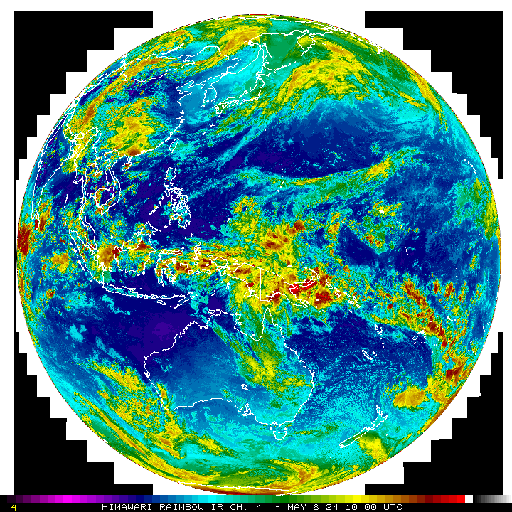 But latent heat output from a phase change is the same regardless of the ambient temperature. So how can infrared from water phase changes to lower energy states indicate ambient temperature? There is more to read and more references I about to fly again - I may have time to read on the aircraft.  Nautonnier, I have the same question. I think the answer probably is that the IR is providing the information with which to determine the temperature of the ambient air or water droplets and has nothing to do with phase change. Dark red colors just shows the temperature is very cold and this means the cloud tops are very high. |
|
|
|
Post by nautonnier on Sept 21, 2017 21:56:58 GMT
An interesting paper and it may be that some of what was in the references has led to the 'misstatements' on what is actually shown in the multispectral images from satellites.
"Nichols and Lamar (1968) developed the idea of an infrared line
scan camera. It scans an object simultaneously over three separate
spectral ranges and produces an image of the object as a color
photograph. The three spectral regions are 0.5–1.0 μm, 3.0–5.5 μm,
and 8–14 μm. Each of the infrared spectral ranges is rendered in one of
the primary colors—blue, green and red, respectively. As a result, the
color of objects in a picture indicates their temperature and also their
reflective and emissive properties"The infrared imagery is repeatedly stated as 'colored to show temperature' But latent heat output from a phase change is the same regardless of the ambient temperature. So how can infrared from water phase changes to lower energy states indicate ambient temperature? There is more to read and more references I about to fly again - I may have time to read on the aircraft. Nautonnier, I have the same question. I think the answer probably is that the IR is providing the information with which to determine the temperature of the ambient air or water droplets and has nothing to do with phase change. Dark red colors just shows the temperature is very cold and this means the cloud tops are very high. And cloud tops at 45,000ft the kind of level that those cloud tops are - would be around minus 56C I would not expect a huge amount of infrared from ice at that temperature - but it is solid red. Do you expect those large amounts of infrared from ice crystals at -56C? |
|
|
|
Post by glennkoks on Sept 22, 2017 1:20:12 GMT
Update post Harvey day 23... Once again I would like to thank everyone for the support. The last 3 weeks have been a blur. There has been an overwhelming amount of help and support from neighbors, friends and even complete strangers. The first three days were spent emptying the contents of my home into a huge pile on the curb, tearing out carpet, drywall and insulation up to the 4' mark. The next 11 days were spent de-humidifying my home. The rebuilding process is going well. Drywall is about 90% replaced and the tape and floating process has begun. "Hoping" to move back in by Halloween... As for the storm details. Rain started falling on Friday, August 29th as the outer bands of Harvey passed through. Saturday evening at about sunset all hell broke lose. Rain came down in buckets and did not stop until Tuesday afternoon. Storm totals in my home town of Friendswood, TX were officially 51.8 inches for the five day total. Over a year worth of rain. Bayou's, creeks and rivers all crested and poured over. Over 3000 homes were flooded in my town alone. As bad as this storm was it was certainly not unprecedented. Amelia in 1978 dumped 48" of rain over parts of Texas. Claudette in 1979 dumped 42" in 24 hours on Alvin, Tx. (still the one day highest rain total in the lower 48) and Allison in 2003 dumped 35+ over a widespread area of Southeast Texas. So it seems we have had four 100 year floods since 1978. Perhaps these extreme rainfall events from stalling tropical storms are a little more common than the USGS thinks they are. I will try to get more pictures posted of the aftermath as time permits. Glad to hear the recovery is moving along well, Mr. Glenn. Have you had a visit with a "storm trooper" yet? phydeaux, It is still a disaster zone. Trash piled up to about 8' on the curbs and it has an odor that repels. Apparently the fine city of Friendswood, TX is demanding that we get a permit and inspection before we even re-insulate or hang drywall. They are concerned about protecting the innocent population from mold. I am almost finished with hanging the drywall and I do not have time to wait for a Bureaucrat to come tell me what I need to do to conform. Keep in mind I only had about 2' of water in my house. Apparently they want to come in and protect me and my family from well I guess.... Myself. I had commercial grade de-humidifiers running in my house before most of the town had power. Down to 13% or less before I started installing insulation. Then I treated all the walls with a mold inhibitor multiple times. When the inspector came by I had to escort him off my property. Other than that I am way ahead of my neighbors. |
|
|
|
Post by sigurdur on Sept 22, 2017 1:32:49 GMT
Glenn: Tell your inspector he needs to go visit the snowflakes. observation clearly shows they have lost their ability to use logic, and their critical thinking skills are lacking.
They could make good use of the "inspectors", as they wouldn't have a clue how to "help" themselves.
|
|
|
|
Post by nautonnier on Sept 22, 2017 18:54:57 GMT
Blustnmntn I don't know what you are doing but it seems to be attracting Maria  |
|
|
|
Post by blustnmtn on Sept 22, 2017 19:27:44 GMT
Blustnmntn I don't know what you are doing but it seems to be attracting Maria I’m actually in VIrginia until Sunday. I think my attitude will repel her back towards the open Atlantic once I get home though (it is a female). |
|
|
|
Post by Ratty on Sept 22, 2017 21:30:11 GMT
Blustnmntn I don't know what you are doing but it seems to be attracting Maria I’m actually in VIrginia until Sunday. I think my attitude will repel her back towards the open Atlantic once I get home though (it is a female). Let's not get into a gender assignment discussion. Does she "feel" female? |
|


