|
|
Post by sigurdur on Oct 29, 2020 17:55:26 GMT
Me wonders if this forecast misses a little of the low-solar, cycle startup, meridianal (loopy) flow pattern that we see in the current system and all over the world. Their forecast looks like an old normal NW to SE normal curve. I think it under-estimates the southward penetration of wacko winter storms this winter.  I remember the 2009-10 winter in Flagstaff. Now that was the winter BEFORE La Nina set in. But the jet ripped way south, west of the coast and roared over the SW, frequently. Flagstaff got buried (happened again last year - same solar cycle setup) and Columbia didn't get a lot. Winter after (2010-11), a La Nina year, Columbia had its biggest snow year in the whole 130-yr record (53" total accumulation). That suggests a different setup with a much greater midwest southward penetration. I'm preparing for lots of snow ... and we'll see. I am preparing to be in Alabama............forget that snow stuff! |
|
|
|
Post by missouriboy on Oct 29, 2020 18:35:24 GMT
Me wonders if this forecast misses a little of the low-solar, cycle startup, meridianal (loopy) flow pattern that we see in the current system and all over the world. Their forecast looks like an old normal NW to SE normal curve. I think it under-estimates the southward penetration of wacko winter storms this winter. I remember the 2009-10 winter in Flagstaff. Now that was the winter BEFORE La Nina set in. But the jet ripped way south, west of the coast and roared over the SW, frequently. Flagstaff got buried (happened again last year - same solar cycle setup) and Columbia didn't get a lot. Winter after (2010-11), a La Nina year, Columbia had its biggest snow year in the whole 130-yr record (53" total accumulation). That suggests a different setup with a much greater midwest southward penetration. I'm preparing for lots of snow ... and we'll see. I am preparing to be in Alabama............forget that snow stuff! It may follow you Sig.  What part of Alabama? |
|
|
|
Post by glennkoks on Oct 29, 2020 21:19:18 GMT
Its odd but La Nina years are supposed to be warmer and dryer on average for us down in the south.
But the coldest winters we ever had 76' 83' and 89' were all La Nina years so we will see.
|
|
|
|
Post by sigurdur on Oct 30, 2020 4:48:23 GMT
I am preparing to be in Alabama............forget that snow stuff! It may follow you Sig. What part of Alabama? Dothan. Lovely area! Cheap monthly rent to boot. |
|
|
|
Post by acidohm on Oct 30, 2020 5:54:46 GMT
Its odd but La Nina years are supposed to be warmer and dryer on average for us down in the south. But the coldest winters we ever had 76' 83' and 89' were all La Nina years so we will see. How chilly the Nina is can have different effects. Here a mild nina is favourable for colder winters but not deeper nina. Statistically speaking. |
|
|
|
Post by acidohm on Oct 31, 2020 5:47:54 GMT
|
|
|
|
Post by acidohm on Oct 31, 2020 7:34:43 GMT
This is waaaay to far out in the model run to be considered as what will happen in reality, but GFS is consistently breaking the polar cell in 2 weeks atm.
This is despite the strat vortex showing every sign of being strong.
You'd expect this kinda trop polar cell disruption to be more associated with ssw.
Simply one to watch for now....just interesting. (But don't sell your coat yet)
For those not used to scrutinising these graphs, low pressure is blue, high red.
Pole should be a nice blue circle (roughly)
That red over Greenland and transiting most of arctic, high level blocking. Zonal flow has stopped, arctic air is spilling south in places.
|
|
|
|
Post by nonentropic on Nov 1, 2020 8:33:45 GMT
www.longpaddock.qld.gov.au/soi/Its going again Ratty! watch out for more hard water in the near future. I may just nip over and get one of those hail damaged cars for my daughter, they are perfect preconditioned for her driving skills.
|
|
|
|
Post by Ratty on Nov 1, 2020 11:13:11 GMT
www.longpaddock.qld.gov.au/soi/Its going again Ratty! watch out for more hard water in the near future. I may just nip over and get one of those hail damaged cars for my daughter, they are perfect preconditioned for her driving skills. The BoM eventually proved right about their wet October forecast: Tinder dry from 1st to 25th Seven + inches 26th to 31st. |
|
|
|
Post by missouriboy on Nov 1, 2020 14:51:01 GMT
An atmospheric Virginia Reel. Really quite beautiful Acid. |
|
|
|
Post by acidohm on Nov 1, 2020 15:01:45 GMT
Yes these animations are amazing!!
The cold influence has evaporated from recent gfs runs however....such is long range model watching 😩
|
|
|
|
Post by missouriboy on Nov 1, 2020 15:57:17 GMT
Lost my GBI update to 2020 ... but will recover. For now a picture of some of the major indices that set the stage on which the game is played. Unless there is something wrong with the indices (possible, but what), "it doesn't take a weatherman to see which way the wind is blowing".  Will update (again) and repeat. Tally-ho! 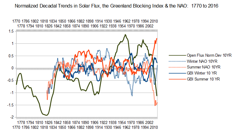 |
|
|
|
Post by missouriboy on Nov 1, 2020 18:59:22 GMT
This is waaaay to far out in the model run to be considered as what will happen in reality, but GFS is consistently breaking the polar cell in 2 weeks atm. This is despite the strat vortex showing every sign of being strong. You'd expect this kinda trop polar cell disruption to be more associated with ssw. Simply one to watch for now....just interesting. (But don't sell your coat yet) For those not used to scrutinising these graphs, low pressure is blue, high red. Pole should be a nice blue circle (roughly) That red over Greenland and transiting most of arctic, high level blocking. Zonal flow has stopped, arctic air is spilling south in places. The Big Ice Cube attracts high pressure and the little blue ovioids dance around the big red blob ... an atmospheric Virginia Reel. In the Reel, we know the rules (although the dancers vary somewhat) because we made them. We are still trying to figure out the rules to the Great Northern Hemisphere Polar Reel. |
|
|
|
Post by sigurdur on Nov 2, 2020 3:07:58 GMT
This is waaaay to far out in the model run to be considered as what will happen in reality, but GFS is consistently breaking the polar cell in 2 weeks atm. This is despite the strat vortex showing every sign of being strong. You'd expect this kinda trop polar cell disruption to be more associated with ssw. Simply one to watch for now....just interesting. (But don't sell your coat yet) For those not used to scrutinising these graphs, low pressure is blue, high red. Pole should be a nice blue circle (roughly) That red over Greenland and transiting most of arctic, high level blocking. Zonal flow has stopped, arctic air is spilling south in places. The Big Ice Cube attracts high pressure and the little blue ovioids dance around the big red blob ... an atmospheric Virginia Reel. In the Reel, we know the rules (although the dancers vary somewhat) because we made them. We are still trying to figure out the rules to the Great Northern Hemisphere Polar Reel. There are no rules, it is much like the rest of climate functions. A chaotic system defying linear explanations. |
|
|
|
Post by missouriboy on Nov 2, 2020 3:32:35 GMT
The Big Ice Cube attracts high pressure and the little blue ovioids dance around the big red blob ... an atmospheric Virginia Reel. In the Reel, we know the rules (although the dancers vary somewhat) because we made them. We are still trying to figure out the rules to the Great Northern Hemisphere Polar Reel. There are no rules, it is much like the rest of climate functions. A chaotic system defying linear explanations. I don't really believe that there are many linear relationships in nature. I do think that one of these days we will know more about how external forcings to our atmosphere express themselves. That doesn't mean you can predict everything. In the old days, people could read the sky and tell when it was time to head for the cellar. Today, the geniuses can tell them how often they SHOULD look at the sky. But maybe there aren't any rules ... |
|


 What part of Alabama?

 Will update (again) and repeat. Tally-ho!