|
|
Post by dontgetoutmuch on Jan 28, 2014 18:12:35 GMT
Hi Sigurdur, I imagine it is rather brisk where you live right now, stay warm!!! As for the possibility of an El Niño next winter, sure it could happen. Of course, obama taking responsibility for and apologizing for the epic fail of Obamacare tonight at the SOTU could happen as well. But I am sceptical. The article you found seems to base it's "prediction" on the fact that it is about time for an El Niño to occur, and of course the models, most of which are provably crap. The Pacific warm pool did warm a little last (Southern Hemisphere fall and winter) year, but it lost most of it's mojo over the past three months. In six months it will still be ENSO neutral, but we will know more... |
|
|
|
Post by graywolf on Feb 2, 2014 17:03:25 GMT
With the PDO 'horse shoe' looking positively PDO+ve (courtesy of the resilient high over the North Pacific) the odds are still looking good for a Nino setting up in Aug of this year? 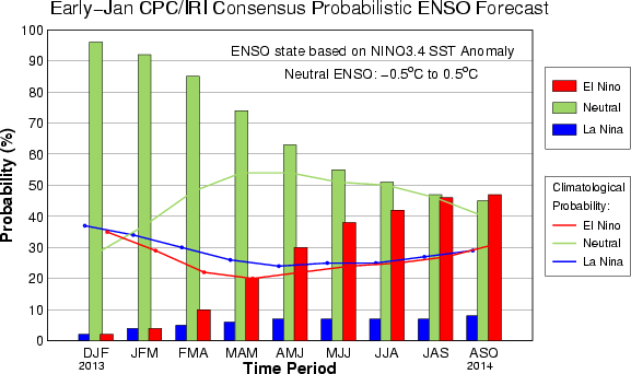 When you look at the plots for the consensus it's clear to see how Nino's chances have been increasing over the past months? The other thing I'm mulling is that the last 'Super Nino' was 16 years ago. The latest paper I saw on Supers indicated that we should expect the 'spacing' between them to reduce from 20 years to 10 years over the coming decades and the last two 'Supers' had only 15 years between them....... maybe we should be thinking about the upcoming Nino turning into a Super? As for the 'Warm Pool'? didn't we see figures putting the temps of the waters, 100m down, hot enough to fuel Typhoon growth over the path of Taiyan? Didn't we see the B.O.M. forecast the record winter because of the heat of the ocean surrounding the Continent? Didn't they do the same for the record summer they are having? ( on top of the record year they just had?). That pool of hot water sloshing around the west of the Pacific seems ready to slosh back east toward the Americas. |
|
|
|
Post by graywolf on Feb 2, 2014 17:04:04 GMT
With the PDO 'horse shoe' looking positively PDO+ve (courtesy of the resilient high over the North Pacific) the odds are still looking good for a Nino setting up in Aug of this year? When you look at the plots for the consensus it's clear to see how Nino's chances have been increasing over the past months? The other thing I'm mulling is that the last 'Super Nino' was 16 years ago. The latest paper I saw on Supers indicated that we should expect the 'spacing' between them to reduce from 20 years to 10 years over the coming decades and the last two 'Supers' had only 15 years between them....... maybe we should be thinking about the upcoming Nino turning into a Super? As for the 'Warm Pool'? didn't we see figures putting the temps of the waters, 100m down, hot enough to fuel Typhoon growth over the path of Haiyan? Didn't we see the B.O.M. forecast the record winter because of the heat of the ocean surrounding the Continent? Didn't they do the same for the record summer they are having? ( on top of the record year they just had?). That pool of hot water sloshing around the west of the Pacific seems ready to slosh back east toward the Americas. |
|
|
|
Post by graywolf on Feb 2, 2014 17:04:47 GMT
double post!
|
|
|
|
Post by sigurdur on Feb 2, 2014 17:23:09 GMT
Good to read it twice....  |
|
ant42
Level 3 Rank
 Melbourne, Australia
Posts: 129
|
Post by ant42 on Feb 3, 2014 20:47:50 GMT
Hi All, been a long time. CFS is the most ridiculous, reactive model going around. It has been forecasting an El Nino for the last 3 years. None of which have come off. The model does not see what happens in a cold PDO. Any warmth that begins to make its way East in a kelvin Wave gets largely chewed up before it reaches Nino 1 and 2. Yes we get some warmth but not enough to see a fully fledged El Nino. Also, El Ninos only average 7 months in a cold PDO and La Ninas 21 months. So any talk of a Super El Nino is folly. In saying that, the question I have been asking myself is do we need to see an El Nino before the next big La Nina? Here in Australia we have had 2 El Nino like summers in a row after record breaking la Nina years in 2011/12. Which incidentally is the normal climate response. We have had cooler waters East and west of us and a persistent upper ridge over the country. But, only the summer months. The remainder has been wet and cooler bar the interior where its been dry for two years. As I see it, LA nina is coming. A large pool of cold water has just appeared in the subsurface that will kill off the next Kelvin Wave. The SOI has been highly positive in the last 3 months, which indicates no westerly wind burst to initiate the next Kelvin Wave anytime soon. If we do happen to have an El Nino later this year, the La Nina that follows will be big yet again. At this stage its 50/50 to have a La nina develop late this year, but not as strong as the last one, which destroyed all rainfall records here for 2010 - 2012. So pay no attention to CFS regarding ENSO, its reactive. Funnily enough the most consistent model is the BOM POAMA model, and those that know me and my blog know that I despise the BOM. But its model is very accurate in the last couple of years. www.bom.gov.au/climate/enso/ |
|
|
|
Post by throttleup on Feb 3, 2014 23:13:22 GMT
Graywolf, thank you for your double post.
Graywolf, thank you for your double post.
I am not familiar with the source material, but I am interested in a short (or long) response regarding the thinking behind the expection that big El Ninos are expected to increase in frequency.
What is the proposed mechanism behind that? Can you elaborate?
Thank you.
Thank you.
|
|
|
|
Post by dontgetoutmuch on Feb 4, 2014 1:14:52 GMT
As usually happens with me, my prediction just got stomped by a guy who knows what he is talking about... Joe Bastardi... patriotpost.us/opinion/23052Joe thinks an El Niño is coming on... |
|
|
|
Post by sigurdur on Feb 4, 2014 2:07:23 GMT
A lot of folks think an El Nino is coming on.........
Unless something changes pretty quickly....I don't see how it will come on.
I think the BOM is correct on this one.
|
|
|
|
Post by sigurdur on Feb 4, 2014 2:36:22 GMT
|
|
ant42
Level 3 Rank
Melbourne, Australia
Posts: 129
|
Post by ant42 on Feb 4, 2014 7:18:24 GMT
There is a good reason why everyone thinks one is coming on, and that's because we are due.
Since 2006 we have had 4 La Nina years, one El Nino and 2 neutral.
If you extrapolate that out it will be 6 la Ninas, 2 El Ninos and 4 neutrals by 2018/19. Or even 7 and 3.
Joe B is hardly ever wrong but last year he said it was coming on in July (which it was), and then it got crushed and we almost had a La Nina by Xmas.
That's what makes it so interesting, it really does do what it wants, irrespective of Co2 or James Hansen.
|
|
|
|
Post by karlox on Feb 5, 2014 8:47:48 GMT
I can perfectly recall how during the 90´s claim was made that EL NIÑO events were and would become more frequent and intense due to global warming. Next our Sun´s cycles started a downhill trend and gave birth to Cycle 24. Coincident (?)with less and less frequent EL NIÑO events, flat to lower decadal temps trend and an increase in Global Ice Volume with Antartica leading recovery...
Please Correct me if I am wrong or missing something...
|
|
|
|
Post by graywolf on Feb 6, 2014 10:22:53 GMT
I think the biggest problem with the formation of the Nino is the collapse of the Walker cell ( allowing the trades to fail and the waters to slosh back to the east) and whilst that high sits over the north Pacific the circulation to its base just helps maintain the Trades. See the high fill and we may see enough of a stall in the trades to see the collapse take place?
As for expecting more powerful Nino's does not the reduction in spacings between 'Supers' fill that remit? If the last two 'Supers' had only 15 , and not 20, years between them is this not an 'increase' in more intense El Ninos?
As for a move to Nino pushing record global temps? Well we normally see a 4 month 'lag' in global temp response to ENSO forcing ( 6 months for a 'Super') so 2014's temps will be built solely on the ENSO neutral (La Nada) forcings. Seeing as we posted top 4 behind Nino years for 2013 on a Nina dominated, Nada ending year then a pure Nada year looks likely to post a top 5 temperature year. 2015, should Nino develop, will be the record year with any move to Super bringing a step change like 98' did to global temps back then ( and set a new base point for future Deniers graphs! LOL).
Personally I'm waiting for the ITCZ to hit the equator before looking for changes to occur? Remember 98's Super formed over 3 weeks in April 97' when it went from Neutral to full blown Nino due to the piled up waters over the west Pacific suddenly flooding back east. When the seasonal impacts of the sun crossing the Equator begin to fully influence this is when I expect the Trade wind hiccup to allow the dam to break.
|
|
|
|
Post by icefisher on Feb 7, 2014 13:11:06 GMT
2015, should Nino develop, will be the record year with any move to Super bringing a step change like 98' did to global temps back then ( and set a new base point for future Deniers graphs! LOL). Yep, even during the hey days of global warming, 3 consecutive years of negative 6 year cooling trends was evident with each solar cycle. It would be catastrophic if this solar cycle didn't produce at least 2 years of 7 years of warming trend. By 2016 if not it will be an election issue and folks whose livelihood depends on it better start networking outside of the issue soon so as to have something to fall back on. Maintaining a hopeful outlook is pretty risky with next stop after 2016 being solar minimum. I mean lets face it graywolf! Warming has even been relatively anemic during the so called catastrophic warming of the 80's and 90's. Warming over the past 30 years has been on a pace of less than 1.5degC for a century. Thats a far cry from the cherry picking of data by the IPCC and certain greened scientists that kept trying to pump it up to at least 3 degrees per century. Instead of acceleration we have deceleration of warming. A .2degC "step" change at this point in time won't even maintain the pace of yesteryear. Even with a .2degC step change it seems likely the cooler head types like Judith Curry are going to prevail. I am sure all of us will be looking closely to see who is closer to the truth, Astromet or mainstream climate science. Astromet has global cooling by the end of 2017, which doesn't allow for more than a brief solar max surge due to an El Nino, which would not qualify as a step change, similar to the cold surges seen during the heyday of global warming which also did not qualify. The gloves are on the table and its not long until a winner is declared, either astrology or the world's university system. |
|
|
|
Post by nautonnier on Feb 8, 2014 13:38:19 GMT
To have an El Nino there is a need to have a nice warm pool across by Indonesia.  I don't see it. What I do see is a long tongue of cooler water across the central Pacific which because it has cold pools North and South of it has not triggered the normal La Nina pressure changes in the Nino 3.4 boxes. The models are all geared to a nice clean SST anomaly pattern and associated winds as they have seen in the satellite era warm PDO; they are showing that they cannot cope with a cold PDO. It is even possible that with the Sun in a funk that the 'cold PDO' will be a special one in some way rather than follow a nice regular pattern as it is repeatedly claimed that it will. |
|