|
|
Post by blustnmtn on Jul 16, 2019 11:40:47 GMT
|
|
|
|
Post by Ratty on Jul 16, 2019 12:04:59 GMT
I prefer the Sun over carbon dioxide. 
|
|
|
|
Post by blustnmtn on Jul 16, 2019 12:35:14 GMT
I prefer the Sun over carbon dioxide. I admit to general skepticism regarding just about everything I read these days. If indeed the alignment of Earth, Jupiter and Venus cause tidal cycles on the Sun that we see as the ~11 year Solar Cycle than it is not much of a stretch for those tidal forces to have an effect on the plate tectonics here on Earth. Gravity may be a “weak” force but it’s relentless! Barry gets his way 😎 |
|
|
|
Post by nautonnier on Jul 17, 2019 10:07:41 GMT
It would be interesting to be able to match seismic events (earthquakes and volcanic eruptions) to the motion of the barycenter and the Earth's orbital position. I hypothesize that when the Earth is under the most inertial stress is when there will be the most seismic activity. Perhaps when I have more time ;-) |
|
|
|
Post by missouriboy on Jul 17, 2019 14:25:24 GMT
Barry's Geotechtonic Concerto in D Minor. Hold on at points where the tempo quickens ... or towards the end of a dramatic pause.  Vivaldi? Or Bach? |
|
|
|
Post by Ratty on Jul 18, 2019 0:14:34 GMT
Vivaldi? Or Bach?Either. And Mozart every note is sheer perfection. 
|
|
|
|
Post by missouriboy on Jul 18, 2019 3:30:25 GMT
Requiem For a Solar Grand Maximum We will miss her 
|
|
|
|
Post by acidohm on Jul 18, 2019 19:10:18 GMT
Requiem For a Solar Grand Maximum We will miss her
I used to sing Requiem in a choir as a tenor...this was my favourite 'piece' to sing... |
|
|
|
Post by Ratty on Jul 18, 2019 23:14:11 GMT
" I used to sing Requiem in a choir as a tenor...this was my favourite 'piece' to sing..." I didn't see anyone in the video with a plunger. Where were you standing? |
|
|
|
Post by missouriboy on Jul 19, 2019 7:16:18 GMT
Volcanic Temperature Impacts for Summers Centered on Cold Periods
ca. 540 AD and 1815 AD (Altai Mtns and the Alps)
I lifted this from Adapt2030. The video it comes from is at the link below. Have a good decade. Looks possible that the false Gods of Climate Science may get their >2 C change, but they got their sign(s) wrong. www.youtube.com/watch?v=4I53GXBUdMAIt's unfortunate that I cannot find a direct reference to the published article and data sources for this chart. 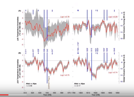
|
|
|
|
Post by acidohm on Jul 20, 2019 10:38:23 GMT
|
|
|
|
Post by acidohm on Aug 3, 2019 18:48:38 GMT
|
|
|
|
Post by missouriboy on Aug 3, 2019 19:50:22 GMT
Is it time to visit Sams Club? Maybe not yet. The island is still there. Wake me when the island disappears into the stratosphere. |
|
|
|
Post by acidohm on Aug 3, 2019 21:26:23 GMT
Is it time to visit Sams Club? Maybe not yet. The island is still there. Wake me when the island disappears into the stratosphere. Yes......but dont you reckon these are escalating Missouri?? 6th biggun in 3 (?) Months, certainly highest yet.... |
|
|
|
Post by missouriboy on Aug 3, 2019 22:27:27 GMT
Is it time to visit Sams Club? Maybe not yet. The island is still there. Wake me when the island disappears into the stratosphere. Yes......but dont you reckon these are escalating Missouri?? 6th biggun in 3 (?) Months, certainly highest yet.... Yes. And I reckon that if this minimum goes on for another 6 to 9 months, we could get a rare treat ... black snow. I wonder what the progression of global volcanic activity looked like prior to Tambora and Krakatoa. Web lists generally only show the bigger ones. TAMBORA The 1815 explosion had an estimated VEI of 7.[9] An estimated 41 cubic kilometres (9.8 cu mi) of pyroclastic trachyandesite were ejected, weighing about 10 billion tonnes. This left a caldera measuring 6–7 kilometres (3.7–4.3 mi) across and 600–700 metres (2,000–2,300 ft) deep.[7] The density of fallen ash in Makassar was 636 kg/m3 (1,072 lb/cu yd).[10] Before the explosion, Mount Tambora's peak elevation was about 4,300 metres (14,100 ft),[7] making it one of the tallest peaks in the Indonesian archipelago. After the explosion, its peak elevation had dropped to only 2,851 metres (9,354 ft), about two-thirds of its previous height.[11] KRAKATOA The 1883 eruption ejected approximately 25 km3 (6 cubic miles) of rock.[3] The cataclysmic explosion was heard 3,600 km (2,200 mi) away in Alice Springs, Australia, and on the island of Rodrigues near Mauritius, 4,780 km (2,970 mi) to the west.[4] While seismic activity around the volcano was intense in the years preceding the cataclysmic 1883 eruption, a series of lesser eruptions began on 20 May 1883. The volcano released huge plumes of steam and ash lasting until late August.[25] On 27 August, a series of four huge explosions almost entirely destroyed the island. The explosions were so violent that they were heard 3,110 km (1,930 mi) away in Perth, Western Australia, and the island of Rodrigues near Mauritius, 4,800 km (3,000 mi) away.[4] The pressure wave from the third and most violent explosion was recorded on barographs around the world.[26] Several barographs recorded the wave seven times over the course of five days: four times with the wave travelling away from the volcano to its antipodal point, and three times travelling back to the volcano;[24]:63 the wave rounded the globe three and a half times. Ash was propelled to a height of 80 km (260,000 ft). The sound of the eruption was so loud it was reported that if anyone was within 16 kilometres (10 mi), they would have gone deaf. The combined effects of pyroclastic flows, volcanic ashes, and tsunamis had disastrous results in the region and worldwide. The death toll recorded by the Dutch authorities was 36,417, although some sources put the estimate at more than 120,000. There are numerous documented reports of groups of human skeletons floating across the Indian Ocean on rafts of volcanic pumice and washing up on the east coast of Africa up to a year after the eruption. Average global temperatures fell by as much as 1.2 °C (2.2 °F) in the year following the eruption. Weather patterns continued to be chaotic for years and temperatures did not return to normal until 1888. |
|


