|
|
Post by nautonnier on Aug 30, 2019 10:17:08 GMT
This could be 'interesting' - tropical storm force winds will arrive even here by Sunday but the hurricane will still be in the middle of Florida - Orlando area on Wednesday.  |
|
|
|
Post by Ratty on Aug 30, 2019 10:37:53 GMT
This is starting to sound scary.
I hope you still have your flashlight and water wings, Naut.
|
|
|
|
Post by nautonnier on Aug 30, 2019 11:35:37 GMT
This is starting to sound scary. I hope you till have your flashlight and water wings, Naut. Currently they are only forecasting around 2ft of rain in our area - so that's not too bad - it is the continual storm force winds that are the problem with the power out. With storm force winds and rain it's like being back in West Scotland - except it's 90F |
|
|
|
Post by blustnmtn on Aug 30, 2019 11:54:37 GMT
This is starting to sound scary. I hope you till have your flashlight and water wings, Naut. Currently they are only forecasting around 2ft of rain in our area - so that's not too bad - it is the continual storm force winds that are the problem with the power out. With storm force winds and rain it's like being back in West Scotland - except it's 90F How far are you from the water? Take care Naut! |
|
|
|
Post by nautonnier on Aug 30, 2019 13:37:45 GMT
Currently they are only forecasting around 2ft of rain in our area - so that's not too bad - it is the continual storm force winds that are the problem with the power out. With storm force winds and rain it's like being back in West Scotland - except it's 90F How far are you from the water? Take care Naut! I am around 2 miles inland of the expected Category 5 storm surge line (nobody knows as there hasn't been a Cat 5 storm hit) and 5 miles direct line to the high tide line -- I did check that in a rare moment of forethought  However, subsequently Katrina showed that on flat land and with a high tide....
"Katrina's powerful right-front quadrant passed over the west and central Mississippi coast, causing a powerful 27-foot (8.2 m) storm surge, which penetrated 6 miles (10 km) inland in many areas and up to 12 miles (19 km) inland along bays and rivers; in some areas, the surge crossed Interstate 10 for several miles."So I am pleased that Dorian is South of here as the tides at the time it arrives are King Tides  When hurricane Matthew ran up the coast it removed a large amount of sand from the dunes that acted as a natural barrier to the sea. See this pic the steps were the end of a boardwalk and were against the dunes before the storm. Imagine what Dorian could do now.  |
|
|
|
Post by nautonnier on Aug 30, 2019 17:21:19 GMT
|
|
|
|
Post by blustnmtn on Aug 30, 2019 19:34:07 GMT
That will make the drive from Naples to Charleston a lot faster! |
|
|
|
Post by nautonnier on Aug 30, 2019 20:45:32 GMT
|
|
|
|
Post by Ratty on Aug 30, 2019 21:50:27 GMT
|
|
|
|
Post by nautonnier on Aug 31, 2019 0:01:41 GMT
It is starting to look like it may do a Matthew which was going to grind up the center of Florida, then follow the type of track shown by Wunderground and ended up 50miles offshore The sea along the East coast of Florida is a shallow continental shelf and doesn't have the energy capacity to feed a Category 5 storm so it does seem they get pulled East by the stronger convection over the deeper water. I could do without a cat 3 passing overhead - cat 2 is exciting enough and we've had that already. |
|
|
|
Post by nautonnier on Aug 31, 2019 1:51:54 GMT
Naut, I have a cousin who lives and works in Boynton Beach about 5 miles from the beach. Sound like you are North? Yes I am around 200 miles North of there just South and West of Daytona Beach so a little further inland. Boynton Beach _might_ be lucky as the new models are curving Dorian North just before landfall which puts Boynton Beach on the less windy part of the storm (for whatever that is worth with a Cat 4) It is the amount of turn to the North that is critical and seems to depend on an anticyclone in mid-Atlantic, if that ridge breaks down faster then the turn North could be earlier or tighter. Some models put it as not coming ashore but coast crawling which would be hugely damaging for the 'Beach Front' aficionados as there are some peninsulas and barrier islands that may be washed away. South Carolina and North Carolina especially the Outer Banks need to worry too. |
|
|
|
Post by sigurdur on Aug 31, 2019 2:41:07 GMT
A bit of hurricane history.
The 1780 Atlantic hurricane season was extraordinarily destructive and was the deadliest Atlantic hurricane season in recorded history with over 25,000 deaths. Four different hurricanes, three in October and one in June, caused at least 1,000 deaths each; this event has never been repeated and only in the 1893 and 2005 seasons were there two such hurricanes. The season also held the deadliest Atlantic tropical cyclone of all time.
|
|
|
|
Post by Ratty on Aug 31, 2019 3:18:39 GMT
Could Dorian do a Sandy? Is the NE better prepared? PS: IMNSHO, Sandy was a big factor in Obama's re-election. I could be wrong, as unlikely as that may be ..... |
|
|
|
Post by nautonnier on Aug 31, 2019 9:45:36 GMT
Could Dorian do a Sandy? Is the NE better prepared? PS: IMNSHO, Sandy was a big factor in Obama's re-election. I could be wrong, as unlikely as that may be ..... Actually (I knew my generator starting second pull meant something  ) Dorian appears to be about to do a Floyd: "Floyd was a large and intense Cape Verde hurricane that pounded the Bahama Islands, seriously threatened Florida, struck the coast of North Carolina and moved up the east coast into New England. It neared category five intensity on the Saffir-Simpson Hurricane Scale as it approached the Bahamas, and produced a flooding catastrophe in the eastern United States, particularly in North Carolina."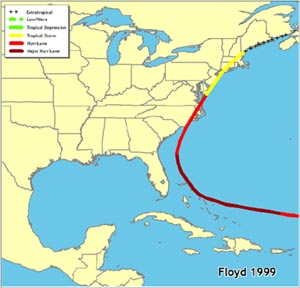 Floyd caused considerable panic in Florida as the long straight track toward central Florida and forecasts of total catastrophe (the media loves showing animations of buildings being destroyed to calm the population  ) Huge traffic jams built up into Georgia. It was a storm at least as big as Dorian is now - and the stationary traffic on the I-95 in Jacksonville area was lashed by tropical storm force winds and flooding rain. 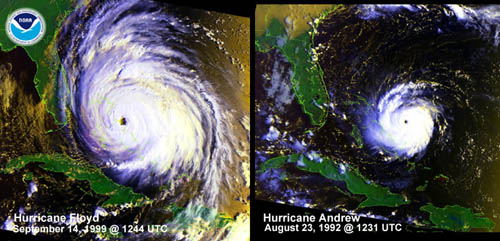 But Dorian's track past Florida is starting to look more like October 2016 Matthew I can remember continual broadcasts of 'get out now' look what a Category 3 storm will do to you all -- everyone is going to DIE (see below). These caused evacuations from the Keys all the way up Florida and again the storm curved just sufficiently East. We had Cat 2 winds for around a day on the East coast of FL www.nhc.noaa.gov/archive/2016/graphics/al14/loop_5W.shtmlYou will note a relatively common theme - the coast of the Carolinas and in particular Cape Hatteras almost always bear the brunt of hurricanes that were forecast to devastate Florida. Calming video of wind effects on houses played ad nauseam by excited presenters..... Note that the house next door is unaffected by the wind Political Note: I think it was not so much the 'superstorm' Sandy that caused the re-election of Obama it was the behavior of Chris Christie during the stop in the campaigning - where he gave Obama a big hug just for turning up.  |
|
|
|
Post by Ratty on Aug 31, 2019 10:40:21 GMT
Political Note:
I think it was not so much the 'superstorm' Sandy that caused the re-election of Obama it was the behavior of Chris Christie during the stop in the campaigning - where he gave Obama a big hug just for turning up. Wait a minute. Now ........... where did I put my Chris Christie doll? 
|
|


 ) Dorian appears to be about to do a Floyd:
 ) Huge traffic jams built up into Georgia. It was a storm at least as big as Dorian is now - and the stationary traffic on the I-95 in Jacksonville area was lashed by tropical storm force winds and flooding rain.