|
|
Post by missouriboy on Jan 9, 2016 2:01:14 GMT
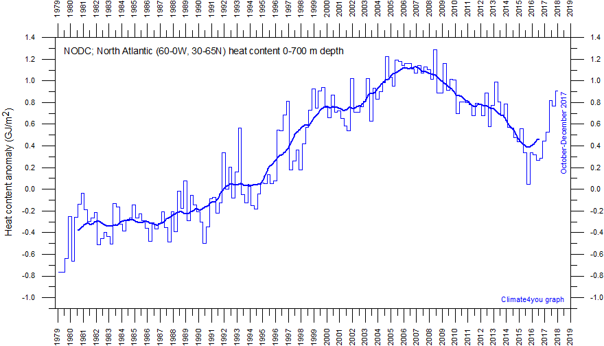
fido.nrk.no/4cf750c3e0b034153d6ea12a898156b4a030f739896889be4a11b4526a97a663/Nature-climate-change.pdfif we can take this paper as an example of a cause of North Atlantic ocean cooling, ie, Greenland meltwater runoff.....is it therefore falsified by existing cooling during a period where the Greenland Icecap would be frozen?? nsidc.org/greenland-today/Not currently melting.... However, as previously pointed out by Missouriboy.....strong, cold labrador current... Another source of freshwater to the Lab current is Hudson Bay... The total area of the Hudson Bay drainage is about 3.8 million km2 and the mean discharge of all the rivers flowing into it is 30 900 m3/s. Something like 1/3 of all freshwater discharged into the arctic circle, comes from Hudson bay. www.thecanadianencyclopedia.ca/en/article/hudson-bay/So, (correct me as soon as i go wrong....) that would be 974,462,400 km3 of water per year?? This to be honest seems alot? Compared to 239 cubic kilometers (57 cu mi) per year melt water from greenland... en.wikipedia.org/wiki/Greenland_ice_sheetMaybe, maybe not........now data on what has been happening upstream of the hudson bay is hard to find....has there been increased preciptation for example?? However i seem to remember that a new icebreaker has been called for to keep shipping lanes open in the Hudson bay?? Has it got colder there?? Good figures Acidohm ... and since I don't have any discharge figures for the Labrador Current (Vague memory of a chart somewhere?) I cannot prove that increases in the Lab are doing the damage. However, I have temperature and salinity values at the interface (~38-40N, 42-50W) that show cross-sectional cold water displacement very large in 2010-11 ... and lesser but >norm in 2007-8 and 2014-15. So ... what do we know. We know the North Atlantic above 40N is getting increasingly colder since about 2010 and particularly since 2014. Heat wise, we know that we probably have three, maybe four, factors accounting for the declining temperature. 1) We have a small outflow at depth (~0.15C) due to overturning ... 2) We have loss to atmosphere of unknown quantity ... 3) We have inflow of colder water from further north (combination northern drainages, Arctic Ocean , Greenland melt and other) ... and 4) We have possible recycle of cold discharge coming down the Lab Pike and getting recirculated(What goes around comes around). AND YOU ARE RIGHT ... seems a lot in comparison to melt ... BUT IT'S ALL COLD UP THERE ... right??? Greenland may be overplayed. But it still appears to be playing Hell in Gulf Stream Land. I'll post those 38-40 cross sections here shortly. Keep up the good work. And I don't know about Drs. Doom and Gloom (Bumper and Thumper). They do what they do. |
|
|
|
Post by sigurdur on Jan 9, 2016 3:50:12 GMT
Hudson Bay: Above average precip in its Basin for 2013 and 2015. The area of Canada/USA that drains into Hudson Bay is HUGE.
|
|
|
|
Post by sigurdur on Jan 9, 2016 3:51:11 GMT
In 2015 the ice stayed in the Bay so long that they had to call in icebreakers.
|
|
|
|
Post by acidohm on Jan 9, 2016 7:39:55 GMT
Im guessing as well after the last couple of winters suffering from the 'blob' effect and getting polar votex down into USA, the temperature of the runoff may also have been below average...
|
|
|
|
Post by missouriboy on Jan 9, 2016 8:51:07 GMT
Im guessing as well after the last couple of winters suffering from the 'blob' effect and getting polar votex down into USA, the temperature of the runoff may also have been below average... Just for a quick comparison, I grabbed and plotted temperatures from 2004 to 2015 for four 1-degree swaths of longitude between 46 and 50 W for 0-100 meters averaged between 45-50 N and 55-65 N. Note that the temperatures have trended generally downward by about 1+C, which is about the same decline that we've seen in the North Atlantic.   |
|
|
|
Post by sigurdur on Jan 12, 2016 1:01:31 GMT
|
|
|
|
Post by missouriboy on Jan 23, 2016 22:16:50 GMT
Note that as of September, 2015 the water-column temperature of the North Atlantic north of 30 N and east of 60 W has declined by -1.1 C, or, i.e., the anomaly index is back to zero. But it leaves off the very warm areas west of 60 W that are above normal (surface temp deviation about +1 C). That AMO should be changing shortly. And once again the East Greenland and West Svalbard Seas increase in temperature, against all odds that I can see.  |
|
|
|
Post by sigurdur on Jan 24, 2016 4:04:52 GMT
Is there an unknown current at play?
|
|
|
|
Post by sigurdur on Jan 24, 2016 4:06:22 GMT
|
|
|
|
Post by missouriboy on Jan 28, 2016 17:02:18 GMT
In this set of screen grabs note how the eastward component of the sub-tropical gyre works its way around the southern edge of the cold water. And that the NAD is failing to penetrate too far up the center. It's 4th and 10 as they would say in American football ... and the coach is not smiling. Cold water is pushing south of 40 North.   |
|
|
|
Post by acidohm on Jan 28, 2016 17:20:42 GMT
In this set of screen grabs note how the eastward component of the sub-tropical gyre works its way around the southern edge of the cold water. And that the NAD is failing to penetrate too far up the center. It's 4th and 10 as they would say in American football ... and the coach is not smiling. Cold water is pushing south of 40 North. Indeed Missouriboy.....something i have been wondering about recently, is how the warm water even gets that warm?? The Gulf Stream temp anomaly makes it look like a 'massive nino' or something...  Its not like its coming from a hot pool of water, it simply gets warmer as it heads up the east coast of USA......im guessing not a massive amount of atmospheric heat/sun to warm it up at this time of year??? The anomaly increases rapidly in a localised area too and must raise 4.5 c in a thousand miles or so.....even if the gulf stream is warm.....it is clearly not meant to be THAT warm! Due to AMOC slowdown ya think??? |
|
|
|
Post by nonentropic on Jan 28, 2016 21:55:45 GMT
I think in absolute temps it may be a lower temperature.
So a faster northern flow will lose energy but still looks like a warming current as it travels north.
key point is something is changed from normal or before. The satellite era is defined as normal currently.
A bit like polar ice the Arctic/antarctic rising or falling in opposite cycle to each other is interesting but until you understand what the driver is its just interesting.
any attachment to CO2 shows ignorance or dishonesty.
|
|
|
|
Post by missouriboy on Jan 28, 2016 22:41:13 GMT
In this set of screen grabs note how the eastward component of the sub-tropical gyre works its way around the southern edge of the cold water. And that the NAD is failing to penetrate too far up the center. It's 4th and 10 as they would say in American football ... and the coach is not smiling. Cold water is pushing south of 40 North. Indeed Missouriboy.....something i have been wondering about recently, is how the warm water even gets that warm?? The Gulf Stream temp anomaly makes it look like a 'massive nino' or something... Its not like its coming from a hot pool of water, it simply gets warmer as it heads up the east coast of USA......im guessing not a massive amount of atmospheric heat/sun to warm it up at this time of year??? The anomaly increases rapidly in a localised area too and must raise 4.5 c in a thousand miles or so.....even if the gulf stream is warm.....it is clearly not meant to be THAT warm! Due to AMOC slowdown ya think??? That heat is just not getting north. Either by dilution or blockage or  Given that these are anomalies (SSTAs) I think it looks worse than it is ... and that is if the anomaly is based on that month's long-term base line. If the anomaly is based on annual, then the winter months would look much worse. As the following chart shows, there HAS been significant heat accumulation in the western side of latitude zone 20-40 N. This matches the intensity, if not the quantity of the surface temperatures of the Eastern Pacific tropical zone (15 S - 15 N). Note how puny the 2009 El Ninolooks in comparison to the 2015 'Abnormally High SSTA Zone'. Wow, that's a mouth full. El Ninos' just aren't what they used to be I guess.    |
|
|
|
Post by sigurdur on Jan 29, 2016 19:49:58 GMT
|
|
|
|
Post by acidohm on Jan 29, 2016 19:57:39 GMT
Indeed Missouriboy.....something i have been wondering about recently, is how the warm water even gets that warm?? The Gulf Stream temp anomaly makes it look like a 'massive nino' or something... Its not like its coming from a hot pool of water, it simply gets warmer as it heads up the east coast of USA......im guessing not a massive amount of atmospheric heat/sun to warm it up at this time of year??? The anomaly increases rapidly in a localised area too and must raise 4.5 c in a thousand miles or so.....even if the gulf stream is warm.....it is clearly not meant to be THAT warm! Due to AMOC slowdown ya think??? That heat is just not getting north. Either by dilution or blockage or  Given that these are anomalies (SSTAs) I think it looks worse than it is ... and that is if the anomaly is based on that month's long-term base line. If the anomaly is based on annual, then the winter months would look much worse. As the following chart shows, there HAS been significant heat accumulation in the western side of latitude zone 20-40 N. This matches the intensity, if not the quantity of the surface temperatures of the Eastern Pacific tropical zone (15 S - 15 N). Note how puny the 2009 El Ninolooks in comparison to the 2015 'Abnormally High SSTA Zone'. Wow, that's a mouth full. El Ninos' just aren't what they used to be I guess.  View AttachmentView Attachment View AttachmentView AttachmentCan we abbreviate that to AHSSTAZ??? |
|


