|
|
Post by Ratty on Aug 5, 2018 23:36:05 GMT
Their "Plain Language Summary" is novel and appreciated. But their charts minus a plain language interpretation (which is behind the paywall) are complexing.  This stuff is really starting to worry me. I almost understood without reading the plain language.  |
|
|
|
Post by missouriboy on Aug 15, 2018 22:19:40 GMT
|
|
|
|
Post by Ratty on Aug 15, 2018 23:20:36 GMT
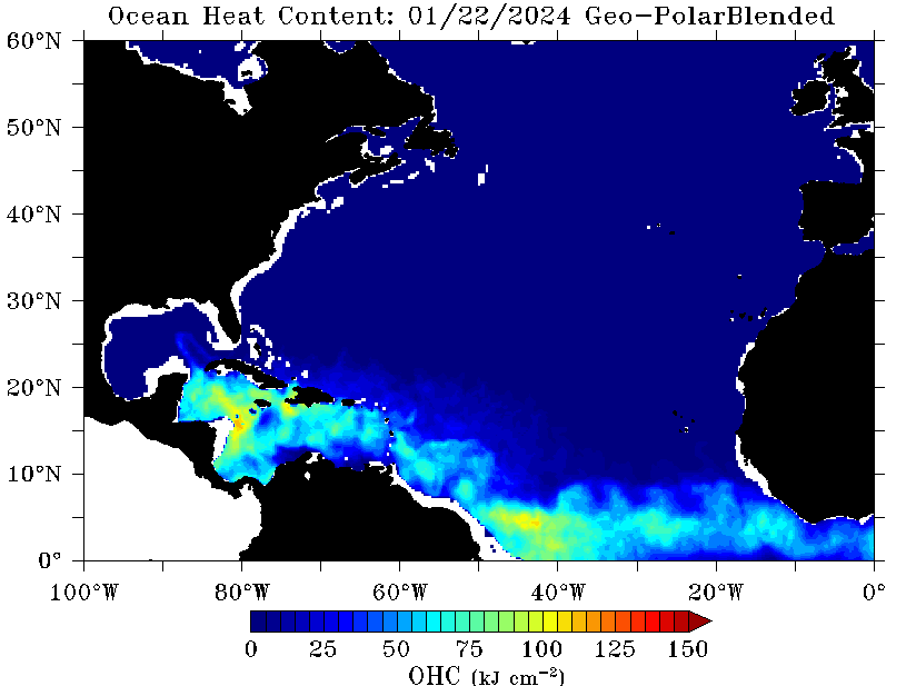
NOAA has much prettier charts ..... Tropical Cyclone Heat Potential Loop:  |
|
|
|
Post by nautonnier on Aug 15, 2018 23:29:49 GMT
Another view - the Caymans are looking warm...  But nothing out of the ordinary But nothing out of the ordinary

Unlike the Mid and South Atlantic that is really cold |
|
|
|
Post by Ratty on Aug 15, 2018 23:38:16 GMT
" the Caymans are looking warm" Counting money will do that ......  |
|
|
|
Post by missouriboy on Aug 28, 2018 23:42:54 GMT
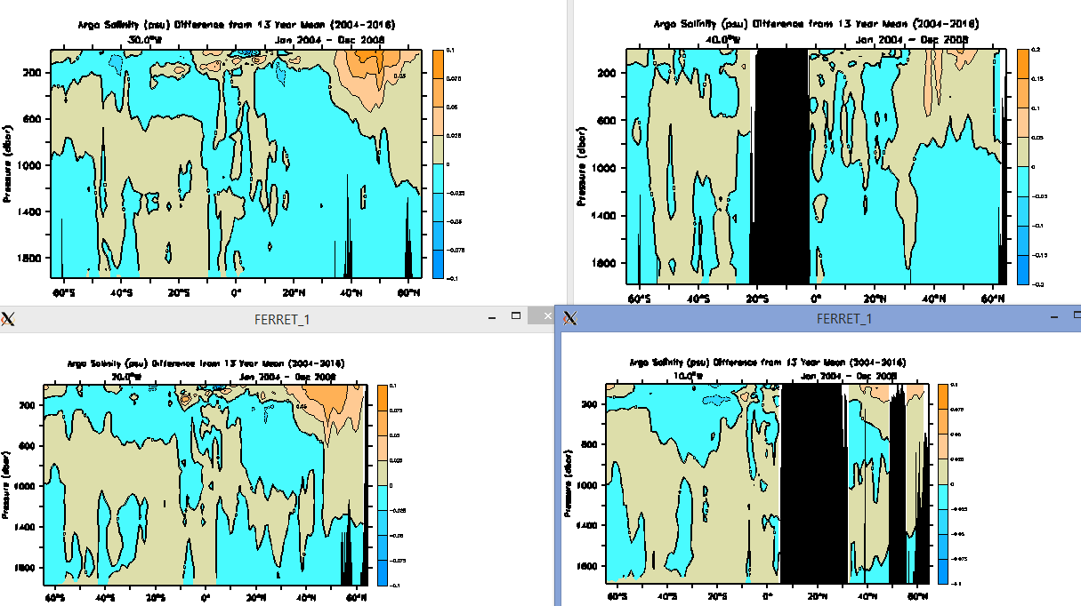
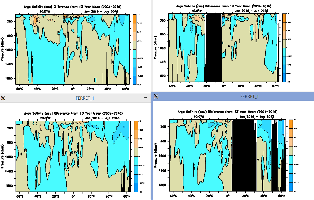
Something Has Happened to Salinity Distributions in the Atlantic Ocean (ARGO)Two charts ... each showing salinity deviations from 0 to 2000 meters from 65 N to 65 S Latitude for four North-South cross-sections at 10 W, 20 W, 30 W and 40 W. First 4-chart series is for period 2004-2008 (downside of SC23). Note salinity plumes in North Atlantic ... very little in S Atlantic. Second 4-chart series is for period 2016-2018 (downside of SC24). Note shift in salinity to South Atlantic. If salinity is a proxy for temperature as well as density, are we seeing some type of fundamental cyclical shift between basins? Thoughts? 2004-2008 2016-2018 2016-2018

|
|
|
|
Post by missouriboy on Aug 29, 2018 23:21:50 GMT
Atlantic Ocean Salinity - The Middle Years at 20 & 30 W Longitude: 2009-11 & 2012-14
During solar minimum (2009-11) the last of the lunar pulse (Dilley) of warm, saline water is still moving north and likely melting Arctic ice. The equatorial zone shows colder, fresher water above 1000 meters. Some (much) of this I remember being from mid-level South Atlantic inputs rotating northward. Overturning appears to still be occurring north. By 2012-14 the Atlantic north of 40 N is very cold and fresh to depth ... presumably from both ice melt and colder surface water moving north (see panels 3 and 4). South of the equator, a warm, saline 'blob' has emerged above 800 meters to 30 S. This is the precursor to those shown in 2016-17 further south. Cold, fresh water extends to depth along the equator ... and if it's rotating north, may continue to cool the AMO. The last obstacle to a cold AMO is likely the NE US Coast warm blob (not shown in these sections) which seems to be emissing in place(?) to near-future oblivion. In plan view, the upper 500m salinity deviations are shown in Figure 2.  
|
|
|
|
Post by acidohm on Sept 12, 2018 19:59:08 GMT
Atlantic Ocean Salinity - The Middle Years at 20 & 30 W Longitude: 2009-11 & 2012-14
During solar minimum (2009-11) the last of the lunar pulse (Dilley) of warm, saline water is still moving north and likely melting Arctic ice. The equatorial zone shows colder, fresher water above 1000 meters. Some (much) of this I remember being from mid-level South Atlantic inputs rotating northward. Overturning appears to still be occurring north. By 2012-14 the Atlantic north of 40 N is very cold and fresh to depth ... presumably from both ice melt and colder surface water moving north (see panels 3 and 4). South of the equator, a warm, saline 'blob' has emerged above 800 meters to 30 S. This is the precursor to those shown in 2016-17 further south. Cold, fresh water extends to depth along the equator ... and if it's rotating north, may continue to cool the AMO. The last obstacle to a cold AMO is likely the NE US Coast warm blob (not shown in these sections) which seems to be emissing in place(?) to near-future oblivion. In plan view, the upper 500m salinity deviations are shown in Figure 2.   Discusion/paper relevant to this Moboy.... notrickszone.com/2018/09/12/trash-science-exposed-journal-findings-refute-potsdam-institutes-alarmist-gulf-stream-collapse-claims/ |
|
|
|
Post by missouriboy on Sept 23, 2018 18:00:35 GMT
|
|
|
|
Post by nautonnier on Dec 7, 2019 20:36:16 GMT
It might be me but there does not seem to be an awful lot of heat getting up toward Europe...  Labrador current looks strong though as does the Azores current which is getting the warmth that should be going North  |
|
|
|
Post by missouriboy on Dec 7, 2019 21:14:21 GMT
All of Al's horses and all of Al's men Won't bring the south's warmth back to Europe again. Perhaps Greta can help.  |
|
|
|
Post by acidohm on Dec 7, 2019 22:29:22 GMT
At the moment tho i can't help but think its the warm water off PNW which us affecting us the greatest.
It seems to create a rossby wave over US which in turn fires up the jet across the Atlantic.
It is however a cold, more NW wind generally.
A more polar, returning polar maritime air mass.
|
|
|
|
Post by missouriboy on Dec 7, 2019 22:47:31 GMT
At the moment tho i can't help but think its the warm water off PNW which us affecting us the greatest. It seems to create a rossby wave over US which in turn fires up the jet across the Atlantic. It is however a cold, more NW wind generally. A more polar, returning polar maritime air mass. Kinder than the East Beast? |
|
|
|
Post by acidohm on Dec 7, 2019 23:08:25 GMT
At the moment tho i can't help but think its the warm water off PNW which us affecting us the greatest. It seems to create a rossby wave over US which in turn fires up the jet across the Atlantic. It is however a cold, more NW wind generally. A more polar, returning polar maritime air mass. Kinder than the East Beast? Alot kinder, just a bit under average, BFTE can easily be 10°c below average! |
|
|
|
Post by Ratty on Dec 8, 2019 1:53:15 GMT
At the moment tho i can't help but think its the warm water off PNW which us affecting us the greatest. It seems to create a rossby wave over US which in turn fires up the jet across the Atlantic. It is however a cold, more NW wind generally. A more polar, returning polar maritime air mass. Kinder than the East Beast? Our hot beasts come from the West .... apart from cyclones of course. |
|