|
|
Post by hilbert on Dec 8, 2009 0:09:44 GMT
 These are the temperatures in the Arctic. I don't know if it gives a precursor to ice formation or not. |
|
|
|
Post by sigurdur on Dec 8, 2009 0:33:23 GMT
Actually, the temps do. When water is converted to ice, it gives up a lot of heat. One has to account for that heat...and it is in the atmosphere. The warmer temps indicate that a lot of ice is being formed.
|
|
|
|
Post by rocketman938 on Dec 8, 2009 2:34:03 GMT
Actually, the temps do. When water is converted to ice, it gives up a lot of heat. One has to account for that heat...and it is in the atmosphere. The warmer temps indicate that a lot of ice is being formed. Water will release the latent heat of freezing as it transitions to ice, similar to evaporation cooling the air as water turns to vapor. However, cool air will cause the water to freeze faster similar to warm air causing water to evaporate faster. Therefore the warmer temperatures indicate that less ice will be formed. |
|
|
|
Post by sigurdur on Dec 8, 2009 3:03:32 GMT
Actually, the temps do. When water is converted to ice, it gives up a lot of heat. One has to account for that heat...and it is in the atmosphere. The warmer temps indicate that a lot of ice is being formed. Water will release the latent heat of freezing as it transitions to ice, similar to evaporation cooling the air as water turns to vapor. However, cool air will cause the water to freeze faster similar to warm air causing water to evaporate faster. Therefore the warmer temperatures indicate that less ice will be formed. True for later on once the water is covered with ice. But while the water is transitioning to ice, a lot of heat is expressed. This goes in conjuntion with the fastest freeze since 1970. |
|
|
|
Post by poitsplace on Dec 8, 2009 8:49:39 GMT
True for later on once the water is covered with ice. But while the water is transitioning to ice, a lot of heat is expressed. This goes in conjuntion with the fastest freeze since 1970. Hmmm, arctic ocean... 2.8% of the earth's surface receiving 1/3 the energy received at the equator...not really much albedo feedback available, is there? Has to be under .9%...but the ice would continue to provide some albedo for most of the year and the lack of ice would mean there'd be 1-2 meters of ice formed every year (.25% to .5% of the earth's entire energy budget, BTW to make 13million square miles of ice). Doesn't seem like the overall potential for feedback there is significant. |
|
|
|
Post by Purinoli on Dec 9, 2009 11:43:18 GMT
Water will release the latent heat of freezing as it transitions to ice, similar to evaporation cooling the air as water turns to vapor. However, cool air will cause the water to freeze faster similar to warm air causing water to evaporate faster. Therefore the warmer temperatures indicate that less ice will be formed. True for later on once the water is covered with ice. But while the water is transitioning to ice, a lot of heat is expressed. This goes in conjuntion with the fastest freeze since 1970. I'll repeat my post from past : Specific heat for melting ice is 334 J/g ( energy needed to melt 1 g of ice at 0 C to 1 g of H2O at 0C). Heat of sublimation is surprisingly high : 2,835 J/g of ice at 0C. Heat of evaporation : 2,510 J/g at 0C and 2,259 at 100C Don't forget that also heat (336 J/g ice) is released when 1 g of H2O at 0C freezed into 1 g of ice at 0C, so called latent heat. All data also depends of pressure.... books.google.si/books?id=QnzHkFN3.... age&q=&f=false It is obvious that some lack of heat is the only cause of freezing ( because it must surpass latent heat nad because "natural state" of Earth is around -15to-18 oC if there is no greenhouse effect ). This can come only by cooler air and this comes mainly from lack of Sun's energy. Everything is more or less in the seasons ballance . Streams of water, winds, pressure.....are of course also major factors of influence. If there is no greenhouse gases ( mainly water), the temp. of Earth would be some 30 oC cooler as it is now. |
|
|
|
Post by neilhamp on Dec 9, 2009 14:05:36 GMT
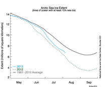
JAXA data showing a downward blip. Can anyone explain?
|
|
|
|
Post by hairball on Dec 9, 2009 14:42:17 GMT
|
|
|
|
Post by jimcripwell on Dec 9, 2009 16:00:44 GMT
neilhamp writes "JAXA data showing a downward blip. Can anyone explain?"
Dont forget the ice is floating. It is always possible for there to be less ice, spread over a bigger area. By the same token, there can be more ice spread out over a smaller area. I have no idea what is actually happening.
|
|
|
|
Post by jurinko on Dec 9, 2009 17:08:32 GMT
JAXA data showing a downward blip. Can anyone explain? No doubt, all that hot air released from Copenhagen goes north and melts some ice. |
|
|
|
Post by kiwistonewall on Dec 9, 2009 18:41:30 GMT
But seriously folks:
The ice was ahead "of itself" near Alaska, and may be suffering a real reversal - OR, there may be weather conditions that make the ice hard to "see" from the satellites there.
Meanwhile, the ice is growing steadily in Hudson Bay & Barents, though a few days behind normal.
|
|
|
|
Post by brian0707 on Dec 9, 2009 19:04:11 GMT
I often come to this board to follow some of the latest debates and developments on global warming. I am active in the energy business, although my undergraduate degree was in biology of all things. So I am well versed in the scientific method - although in some of the discussions here the scientific debate gets a little bit to technical.
Nonetheless, I very much appreciate the politeness of the discourse and the absence of hysteria - on both sides.
So I have a question. Am I the only person who after visiting the NSIDC site comes away with this wierd sense that, after Copenhagen, we are going to see a sharp incline in the sea ice extent.
Its not the prominent graph that bugs me. Its the (processed) satellite view, I think as at December 3, of the arctic circle. Hudons Bay looks almost completely void of ice on the image.
Has anybody in Churchill MN had a look outside in the past few days?
|
|
|
|
Post by jimcripwell on Dec 9, 2009 19:15:38 GMT
brian0707 writes "Has anybody in Churchill MN had a look outside in the past few days? "
During November, the parts of Canada around and south of Hudson Bay had very mild weather. It is only in the last week or so that temperatures have fallen to average and below average. Now, there is very cold weather over Hudson Bay, and it would be surprising if it did not freeze over completely well before Christmas.
|
|
|
|
Post by brian0707 on Dec 9, 2009 19:16:59 GMT
As well, although one year in no way means a trend, does the more rapid ice development over Siberia and Alaska - NSIDC suggests its at or above the 79-00 average - perhaps suggest the growing influence of the negative PDO phase? Or is the present PDO anomaly, whatever it may be, immaterial?
|
|
|
|
Post by brian0707 on Dec 9, 2009 19:18:10 GMT
Thank you Jim. Appreciate the info.
|
|