|
|
Post by karlox on Nov 28, 2012 18:10:47 GMT
Besides, I don´t mean necessarily that air temperatures are lower than average... they might even be -as a mean average- higher in NH for this time of the year... but except for the areas that are developping a drought conditions due to blocking Highs, it looks quite wet... plus the cooling (retarded) of the ocean if this trend continues... interesting
|
|
|
|
Post by nautonnier on Nov 29, 2012 11:37:27 GMT
karlox: You most certainly are reading this correctly. We are entering a period of somewhat rapid cooling. What surprises me is how fast the oceans are shedding heat. I was trying to find some current data in regards to H2O levels in the troposphere. No luck yet. IF H2O has dropped, that would explain the rapid decline in temperatures. H2O is still by far the largest heat retention greenhouse gas. The bands of absorbtion overlap CO2, and that is why CO2 is a minor item in the large picture. I´ve got the feeling that a lot of more humid warmer air lows developping from Mexican Gulf and east coast of US is bringing a lot of humidity to some parts of NH, these lows -of which Sandy is the extreme- seems to draw a lot of cold air west into the US, then whenever in higher latitudes after ascending northeastwards they enter in the polar area and go to Europe, hitting mostly western part of the continent: UK, France... but I look to meteo sat images daily and NH looks very cloudy and unsettled... as it should be probably, but got the feeling it is in general wetter -excep for central US?- though I am not sure you meant that by H2O content in troposphere... Karlox, you can watch what is happening on these two GOES imagery loops: www.ssd.noaa.gov/goes/east/natl/loop-wv.html This shows water vapor over the North Atlantic and the eastern USA and www.ssd.noaa.gov/goes/east/natl/flash-rb.html Showing outgoing longwave radiation as a 'rainbow' image. You can see the latent heat being radiated from water as it condenses and freezes in weather systems. And just to add - the water around Florida and the eastern Gulf of Mexico is a LOT cooler than normal - so the origin of the Gulf Stream and the North Atlantic Drift is colder - does not auger well for North West Europe this winter.  |
|
|
|
Post by karlox on Nov 29, 2012 12:34:15 GMT
I´ve got the feeling that a lot of more humid warmer air lows developping from Mexican Gulf and east coast of US is bringing a lot of humidity to some parts of NH, these lows -of which Sandy is the extreme- seems to draw a lot of cold air west into the US, then whenever in higher latitudes after ascending northeastwards they enter in the polar area and go to Europe, hitting mostly western part of the continent: UK, France... but I look to meteo sat images daily and NH looks very cloudy and unsettled... as it should be probably, but got the feeling it is in general wetter -excep for central US?- though I am not sure you meant that by H2O content in troposphere... Karlox, you can watch what is happening on these two GOES imagery loops: www.ssd.noaa.gov/goes/east/natl/loop-wv.html This shows water vapor over the North Atlantic and the eastern USA and www.ssd.noaa.gov/goes/east/natl/flash-rb.html Showing outgoing longwave radiation as a 'rainbow' image. You can see the latent heat being radiated from water as it condenses and freezes in weather systems. And just to add - the water around Florida and the eastern Gulf of Mexico is a LOT cooler than normal - so the origin of the Gulf Stream and the North Atlantic Drift is colder - does not auger well for North West Europe this winter. Nautonnier, magnific links! Thank you! I´ve been checking a few ago weather forecast from Spanish Meteo Office. Check www.aemet.es/es/eltiempo/prediccion/modelosnumericos/ceppm?opc2=hn&opc3=supNow warm humid lows are coming from mid Atlantic warmer pool rather than from Gulf and Florida, going their way northwards becoming very strong lows that finally melt wiht polar vortex... That´s being the patternd lately. I feel a very large storm-galern is about to form in North Atlantic within a few days, affecting severily weather in Uk, Western Europe, Iberia, and that will be the result of the merging of several cold and warms lows... It looks a lot of bad weather in USA as well... I find it fascinating... although I am bein very especulative... sorry |
|
|
|
Post by thermostat on Dec 5, 2012 4:06:30 GMT
What is going on in the Arctic these days? One data source is the Danish Centre for Ocean and Ice where they post an ongoing record of average Arctic surface temperatures. Here is the current DMI plot showing present Arctic temperatures vs average Arctic readings. ocean.dmi.dk/arctic/meant80n.uk.php |
|
|
|
Post by thermostat on Dec 5, 2012 4:23:46 GMT
While the decline in Arctic Sea Ice volume is most fundamental to understanding current seasonal oscillations of Ice extent, present Arctic Sea Ice observations continue to be of interest. Cryosphere Today has the latest: arctic.atmos.uiuc.edu/cryosphere/ where compared with the historical data set the large expanse of open water on the European side is most conspicuous. From a geophysics perspective, this open water is conspicuously indicative of heat that has been added to the system. Furthermore, this open water would be expected to affect/alter weather patterns during the Northern Hemisphere winter. It is quite unusual from an historical perspective. |
|
|
|
Post by icefisher on Dec 5, 2012 5:17:20 GMT
What is going on in the Arctic these days? One data source is the Danish Centre for Ocean and Ice where they post an ongoing record of average Arctic surface temperatures. Here is the current DMI plot showing present Arctic temperatures vs average Arctic readings. ocean.dmi.dk/arctic/meant80n.uk.phpA close study of the 3 charts below will suggest that the warm temperatures are mostly the effect of accelerated ice formation releasing energy into the atmosphere.  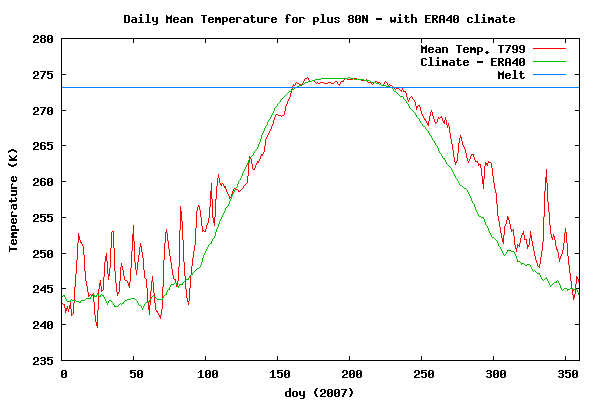 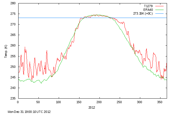 |
|
|
|
Post by thermostat on Dec 5, 2012 5:32:05 GMT
What is going on in the Arctic these days? One data source is the Danish Centre for Ocean and Ice where they post an ongoing record of average Arctic surface temperatures. Here is the current DMI plot showing present Arctic temperatures vs average Arctic readings. ocean.dmi.dk/arctic/meant80n.uk.phpA close study of the 3 charts below will suggest that the warm temperatures are mostly the effect of accelerated ice formation releasing energy into the atmosphere. Raising the question, how does the present differ from the past where the Arctic Ocean was not loaded with such heat? Does it matter? How? |
|
|
|
Post by icefisher on Dec 5, 2012 5:33:25 GMT
I´ve got the feeling that a lot of more humid warmer air lows developping from Mexican Gulf and east coast of US is bringing a lot of humidity to some parts of NH, these lows -of which Sandy is the extreme- seems to draw a lot of cold air west into the US, then whenever in higher latitudes after ascending northeastwards they enter in the polar area and go to Europe, hitting mostly western part of the continent: UK, France... but I look to meteo sat images daily and NH looks very cloudy and unsettled... as it should be probably, but got the feeling it is in general wetter -excep for central US?- though I am not sure you meant that by H2O content in troposphere... Karlox, you can watch what is happening on these two GOES imagery loops: www.ssd.noaa.gov/goes/east/natl/loop-wv.html This shows water vapor over the North Atlantic and the eastern USA and www.ssd.noaa.gov/goes/east/natl/flash-rb.html Showing outgoing longwave radiation as a 'rainbow' image. You can see the latent heat being radiated from water as it condenses and freezes in weather systems. And just to add - the water around Florida and the eastern Gulf of Mexico is a LOT cooler than normal - so the origin of the Gulf Stream and the North Atlantic Drift is colder - does not auger well for North West Europe this winter. Check out the purple water forming on the Ecuadorian coast. This is the first indicator of a possible La Nina. |
|
|
|
Post by thermostat on Dec 5, 2012 5:40:51 GMT
Karlox, you can watch what is happening on these two GOES imagery loops: www.ssd.noaa.gov/goes/east/natl/loop-wv.html This shows water vapor over the North Atlantic and the eastern USA and www.ssd.noaa.gov/goes/east/natl/flash-rb.html Showing outgoing longwave radiation as a 'rainbow' image. You can see the latent heat being radiated from water as it condenses and freezes in weather systems. And just to add - the water around Florida and the eastern Gulf of Mexico is a LOT cooler than normal - so the origin of the Gulf Stream and the North Atlantic Drift is colder - does not auger well for North West Europe this winter. Check out the purple water forming on the Ecuadorian coast. This is the first indicator of a possible La Nina. The ENSO oscillation is quite fascinating. Here is a useful link to follow this phenomenon. www.cpc.ncep.noaa.gov/products/analysis_monitoring/lanina/enso_evolution-status-fcsts-web.pdf |
|
|
|
Post by karlox on Dec 5, 2012 11:30:02 GMT
|
|
|
|
Post by karlox on Dec 5, 2012 11:39:29 GMT
While the decline in Arctic Sea Ice volume is most fundamental to understanding current seasonal oscillations of Ice extent, present Arctic Sea Ice observations continue to be of interest. Cryosphere Today has the latest: arctic.atmos.uiuc.edu/cryosphere/ where compared with the historical data set the large expanse of open water on the European side is most conspicuous. From a geophysics perspective, this open water is conspicuously indicative of heat that has been added to the system. Furthermore, this open water would be expected to affect/alter weather patterns during the Northern Hemisphere winter. It is quite unusual from an historical perspective. Thermostat, there are presently positive SST temperatures anomalies of warm pools within Artic Ocean, warmer than average waters extends through Escandinavia to western Siberia among others spots. Noticeable warm pool close to Labrador, where the cold current seem to be missing... noticeable cool water round Florida and Gulf... and colder La Niña hints by Peru´s Pacific Coast. So what I find most interesting is where both cold and warm anomalies have been building up in past weeks and present...  |
|
|
|
Post by thermostat on Dec 7, 2012 3:38:41 GMT
While the decline in Arctic Sea Ice volume is most fundamental to understanding current seasonal oscillations of Ice extent, present Arctic Sea Ice observations continue to be of interest. Cryosphere Today has the latest: arctic.atmos.uiuc.edu/cryosphere/ where compared with the historical data set the large expanse of open water on the European side is most conspicuous. From a geophysics perspective, this open water is conspicuously indicative of heat that has been added to the system. Furthermore, this open water would be expected to affect/alter weather patterns during the Northern Hemisphere winter. It is quite unusual from an historical perspective. Thermostat, there are presently positive SST temperatures anomalies of warm pools within Artic Ocean, warmer than average waters extends through Escandinavia to western Siberia among others spots. Noticeable warm pool close to Labrador, where the cold current seem to be missing... noticeable cool water round Florida and Gulf... and colder La Niña hints by Peru´s Pacific Coast. So what I find most interesting is where both cold and warm anomalies have been building up in past weeks and present... karlox, Agreed. The redistribution of heat in the ocean system is definitely a big deal. Especially given the high heat capacity of the ocean in comparison with the atmosphere. I would suggest that rather than interpreting the transient movements of heat around the ocean surface, the question of interest becomes how are such movements changing over a more extended time frame and what are the implications of these changes? |
|
|
|
Post by karlox on Dec 7, 2012 8:51:23 GMT
Thermostat, there are presently positive SST temperatures anomalies of warm pools within Artic Ocean, warmer than average waters extends through Escandinavia to western Siberia among others spots. Noticeable warm pool close to Labrador, where the cold current seem to be missing... noticeable cool water round Florida and Gulf... and colder La Niña hints by Peru´s Pacific Coast. So what I find most interesting is where both cold and warm anomalies have been building up in past weeks and present... karlox, Agreed. The redistribution of heat in the ocean system is definitely a big deal. Especially given the high heat capacity of the ocean in comparison with the atmosphere. I would suggest that rather than interpreting the transient movements of heat around the ocean surface, the question of interest becomes how are such movements changing over a more extended time frame and what are the implications of these changes? I agree with you too! I think we´ve got an excess of data and paleoclimate scientist will keep feeding us with more and more reconstructions and data... the ability to put all that data together and run a valid model is still being developped... But, we do know what we don´t know? Are we making the right questions? (as important as getting the right answers) |
|
|
|
Post by thermostat on Dec 8, 2012 6:01:20 GMT
karlox, Agreed. The redistribution of heat in the ocean system is definitely a big deal. Especially given the high heat capacity of the ocean in comparison with the atmosphere. I would suggest that rather than interpreting the transient movements of heat around the ocean surface, the question of interest becomes how are such movements changing over a more extended time frame and what are the implications of these changes? I agree with you too! I think we´ve got an excess of data and paleoclimate scientist will keep feeding us with more and more reconstructions and data... the ability to put all that data together and run a valid model is still being developped... But, we do know what we don´t know? Are we making the right questions? (as important as getting the right answers) karlox, Brilliant question! How does one figure out what one does not know? My current thought, get a lot of ideas, and then throw out the bad ones. Regarding the concept of modeling the climate system, perhaps forum members will be suprised to hear that this approach is only one specific example of a much more widespread approach in physics that is currently being applied to the understanding of a wide variety of complex physical phenomena. I personally view climate models as 'hypotheses'; ie descriptions of the behavior of a complex geophysical system that are subject to experimental analysis; ie. the scientific method - a reasonable approach. |
|
|
|
Post by karlox on Dec 8, 2012 10:06:19 GMT
I agree with you too! I think we´ve got an excess of data and paleoclimate scientist will keep feeding us with more and more reconstructions and data... the ability to put all that data together and run a valid model is still being developped... But, we do know what we don´t know? Are we making the right questions? (as important as getting the right answers) karlox, Brilliant question! How does one figure out what one does not know? My current thought, get a lot of ideas, and then throw out the bad ones. Regarding the concept of modeling the climate system, perhaps forum members will be suprised to hear that this approach is only one specific example of a much more widespread approach in physics that is currently being applied to the understanding of a wide variety of complex physical phenomena. I personally view climate models as 'hypotheses'; ie descriptions of the behavior of a complex geophysical system that are subject to experimental analysis; ie. the scientific method - a reasonable approach. Thermostat -abusing of your warmth post- I would like you to tell me if it sounds to weird something´s being around my head, regarding Maths-Phisycs-Data/Graphs-Maths...Forecast Just from a very instructive for layman video on Fractal Maths, Graphics, concepts and appliance. Basically I figured it out that a Mathematician team provided with reliable data on a sufficient time-span concerning either SFI or SN or ENSO index or... any "cycled" data on any natural scientific measure... and lots of hardware... could start producing "models" as we are dealing basically with what I would call "fractal" sistems with fractac cycles (cicle over cycle over cycle...) So there is a BIG picture and I suppose and hope we are getting closer to it. So: could old-fresh-Maths open new scientific windows to the understanding of our Planet and solar system) If I am misthinking badly, tell me... I´ll take it.  |
|


