|
|
Post by Ufasuperstorm on Jul 16, 2014 20:59:57 GMT
Ouch! (7 day SST forecast) 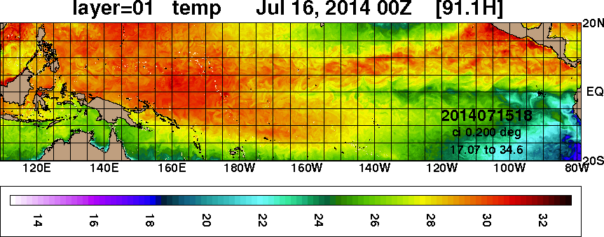 Good Bye Nino Level Warmth |
|
|
|
Post by sigurdur on Jul 16, 2014 23:07:56 GMT
Ouch! (7 day SST forecast) Good Bye Nino Level Warmth Where did u find this ? |
|
|
|
Post by Ufasuperstorm on Jul 17, 2014 0:03:28 GMT
Ouch! (7 day SST forecast) Good Bye Nino Level Warmth Where did u find this ? Sigurdur, First I found the globalsst_nowcast_anim30d.gif at the website below. www7320.nrlssc.navy.mil/GLBhycom1-12/navo/Next I downloaded the gif and unzipped the images. Since this gif shows the past 30 days and the 7 day forecast I recreated the gif with just the 7 day forecast. I also slowed down the frame rate from .5 seconds to 2 seconds so it was easier to see what is going on. If you have any further questions please let me know. Regardless, the remaining warmth is in big trouble. Over the next week anomalously cold SST's will drift westward further dampening the remaining heat. With the weekly 3.4 nino value at .32 Celsius expect a continued cooling through next week. |
|
|
|
Post by sigurdur on Jul 17, 2014 1:07:46 GMT
Ufasuperstorm: Thank you for putting the above together.
|
|
|
|
Post by duwayne on Jul 17, 2014 14:07:32 GMT
ufasuperstorm, that's a great chart. Any chance that you could post the next update when it comes out? Thanks, duwayne
|
|
|
|
Post by dontgetoutmuch on Jul 17, 2014 15:08:39 GMT
Ouch! (7 day SST forecast) Good Bye Nino Level Warmth I would not get overly excited about that gif... That right there is what a feedback loop looks like in a model. Molehill becomes mountain. |
|
|
|
Post by Ufasuperstorm on Jul 17, 2014 15:47:54 GMT
ufasuperstorm, that's a great chart. Any chance that you could post the next update when it comes out? Thanks, duwayne No problem I will post an update next week. Ouch! (7 day SST forecast) Good Bye Nino Level Warmth I would not get overly excited about that gif... That right there is what a feedback loop looks like in a model. Molehill becomes mountain. We have experienced continued moderate cooling basin wide the last two weeks.  Here is the change in SST anomaly from 07/07/2014 to 07/14/2014. Nino 1-2: -.3 C Nino 3.0: -.4 C Nino 3.4: -.1 C Nino 4: 0 C The moderate cooling is ongoing and will continue. (We can thank the Antarctic and low solar activity) I might as well introduce myself. My name is Corey and I have a B.S. in Petroleum Engineering. Climate science has always been one of my hobbies and I have been lurking here for a number of years. I am amazed at the knowledge acquired by some in here. Keep up the good work everyone.  |
|
|
|
Post by nautonnier on Jul 17, 2014 21:43:38 GMT
 No problem I will post an update next week. We have experienced continued moderate cooling basin wide the last two weeks. Here is the change in SST anomaly from 07/07/2014 to 07/14/2014. Nino 1-2: -.3 C Nino 3.0: -.4 C Nino 3.4: -.1 C Nino 4: 0 C The moderate cooling is ongoing and will continue. (We can thank the Antarctic and low solar activity) I might as well introduce myself. My name is Corey and I have a B.S. in Petroleum Engineering. Climate science has always been one of my hobbies and I have been lurking here for a number of years. I am amazed at the knowledge acquired by some in here. Keep up the good work everyone. From an SST point of view that may be moderate cooling - but in kilojoules terms it is huge. That's a lot of heat to lose and will result in a significant cooling of the atmosphere. |
|
ant42
Level 3 Rank
 Melbourne, Australia
Posts: 129
|
Post by ant42 on Jul 18, 2014 0:47:17 GMT
As i said months ago to sigudur this was never going to be a Super El nino.
Not withstanding the fact that there has never been one in a cold PDO period, the coupling of the atmosphere just doesn't happen.
Further, i mentioned this in January and february on my forum, the timing was all wrong.
The heat has peaked in July, and is now being rapidly eroded.
Even a modoki that WB are forecasting is under threat, especially if that SST forecast (fantastic chart btw) that ufasuperstorm put up is correct.
Think the trades are only going to strengthen from here on in.
|
|
|
|
Post by sigurdur on Jul 18, 2014 1:02:53 GMT
We know where the heat is going. North. DMI is not reflecting the increase in volume of heat going north because the strat is lower than normal for an Arctic summer. With the thin troposphere, both ends of the barn are wide open. I can't find the source where I read about the low stratosphere, but the reason expressed was the UV/EUV rays of the light band had a large increase. There is suggestions that UV/EUV regulate the ozone levels of the upper strat which then regulates the temperature which regulates the mass and jet streams.
|
|
|
|
Post by sigurdur on Jul 18, 2014 1:10:05 GMT
As i said months ago to sigudur this was never going to be a Super El nino. Not withstanding the fact that there has never been one in a cold PDO period, the coupling of the atmosphere just doesn't happen. Further, i mentioned this in January and february on my forum, the timing was all wrong. The heat has peaked in July, and is now being rapidly eroded. Even a modoki that WB are forecasting is under threat, especially if that SST forecast (fantastic chart btw) that ufasuperstorm put up is correct. Think the trades are only going to strengthen from here on in. Going to have to dig a bit and see what position the Hadley cells are in. The Rosby wave has finally slid far enough east so that the upper Midwest is going to finally dry out. We of course know that AGW is responsible for the position of the Rosbys and the 6 week cycle in regards to weather. |
|
|
|
Post by dontgetoutmuch on Jul 18, 2014 2:30:00 GMT
We of course know that AGW is responsible for the position of the Rosbys and the 6 week cycle in regards to weather. /sarc There fixed it for ya... |
|
|
|
Post by sigurdur on Jul 18, 2014 4:06:56 GMT
We of course know that AGW is responsible for the position of the Rosbys and the 6 week cycle in regards to weather. /sarc There fixed it for ya... |
|
|
|
Post by cuttydyer on Jul 18, 2014 4:54:11 GMT
We know where the heat is going. North. DMI is not reflecting the increase in volume of heat going north because the strat is lower than normal for an Arctic summer. With the thin troposphere, both ends of the barn are wide open. I can't find the source where I read about the low stratosphere, but the reason expressed was the UV/EUV rays of the light band had a large increase. There is suggestions that UV/EUV regulate the ozone levels of the upper strat which then regulates the temperature which regulates the mass and jet streams. Sig, here's a source:  Abstract/Summary During the descent into the recent ‘exceptionally’ low solar minimum, observations have revealed a larger change in solar UV emissions than seen at the same phase of previous solar cycles. This is particularly true at wavelengths responsible for stratospheric ozone production and heating. This implies that ‘top-down’ solar modulation could be a larger factor in long-term tropospheric change than previously believed, many climate models allowing only for the ‘bottom-up’ effect of the less-variable visible and infrared solar emissions. We present evidence for long-term drift in solar UV irradiance, which is not found in its commonly used proxies. In addition, we find that both stratospheric and tropospheric winds and temperatures show stronger regional variations with those solar indices that do show long-term trends. A top-down climate effect that shows long-term drift (and may also be out of phase with the bottom-up solar forcing) would change the spatial response patterns and would mean that climate-chemistry models that have sufficient resolution in the stratosphere would become very important for making accurate regional/seasonal climate predictions. Our results also provide a potential explanation of persistent palaeoclimate results showing solar influence on regional or local climate indicators. Link: centaur.reading.ac.uk/7206/______________________________________________________ Here's a graphic taken from a Met Office presentation on the mechanism of top down solar modulation:  Link: lasp.colorado.edu/sorce/news/2012ScienceMeeting/docs/presentations/S2-01_Ineson_sorce2012.pdf |
|
|
|
Post by Ratty on Jul 18, 2014 6:55:48 GMT
[ Snip ] We of course know that AGW is responsible for the position of the Rosbys and the 6 week cycle in regards to weather. Sig, can you please list all the other things that AGW is responsible for? No need to include the loss of redheads or snow, cos I already know about thaem.  |
|