|
|
Post by nautonnier on Oct 6, 2016 14:15:33 GMT
Greywolf speaking as someone who may well be under the eye of Matthew in around 16 hours time your levity is not wildly appreciated. Some of the new forecasts put the storm actually running inland now and then up the center of the Florida peninsula so it will hit all the heavily populated areas of Florida some of which are not used to extreme winds. look at Category 4 and 5 in www.nhc.noaa.gov/aboutsshws.php Now imagine that applying to something in the region of 15 million homes. This is not something to joke about. It will be a history altering event and I suspect that there will be many many deaths. |
|
|
|
Post by sigurdur on Oct 6, 2016 14:55:28 GMT
Is there going to be a strong hurricane in Florida? Yes.
Is this the 1st major hurricane to hit Florida? Nope
Will there be property damage? Yep.
|
|
|
|
Post by graywolf on Oct 6, 2016 15:13:05 GMT
Definitely nothing to joke about and , hopefully, something that allows folk to see what increasing storm strengths will bring to an ever wider area. Just looking at the rainfall rates from the Dominican Rep , over a 12 hr period, is chilling esp. here in our valley as Dec 26th saw a mere 3" of rain over that 12 hr period. As we warm and airmasses trend to N/S exchanges we will begin to see the likes of Dec 26th more and more frequently. As with our town folk will get used to just how useless insurance can be esp. the second or 3 rd time of needing to claim ( higher govt. input for those in need?) so the economic impacts are as worrying as the human costs as the 'local' impact becomes a 'national issue'.
After watching the snarl ups when Rita came visiting I have to wonder just how well the stat evac's will go esp. with many 'escape routes' prone to flooding? Then we have the numbers of folk who clearly do not understand the danger they are placing themselves in by refusing to leave their property?
The difference has always been the media coverage in your 1st world nation. As with Katrina we will all get grandstand views of the catastrophe as it unfolds ( unlike Cuba/Haiti) and the aftermath in the months to come.
For whatever reasons the U.S. leads the Denier grouping folk still need to accept that our planet's weather is becoming increasingly extreme with each year that passes. It is only when a high profile event takes place that Joe P. gets to see just what meeting with one of these events means. As with Australia the denial is govt. lead with Republicans blocking legislation that would moderate extreme impacts. eventually the politic will fail as day to day events wises up Joe P. as to just how quickly changes are occurring ( esp. if the do not face such extreme weather events and only face drought/cold/heat events?
As I appreciated your concerns for our homeless/destitute in December last year you can feel rest assured that my sympathies are with you all along the east coast of Florida ( and the 25 miles in;land like;ly to feel the cat 4 gusts as Matthew scrapes by.
Seeing as you are in the area at risk I hope come to no harm and the forecasters are leaning to the top end of the forecast possibilities and that Matty drops to a low cat 2 once it reaches the shallows of the Continental shelf and copes with land interaction?
One thing it will end is the chatter about 'weather manipulation' by govt's as , if possible, this storm would have been squished Before the Bahamas ( I don't think they would have bothered prior to that?) esp. with the amount of aircraft buzzing around it!!!
|
|
|
|
Post by graywolf on Oct 6, 2016 15:22:46 GMT
Is there going to be a strong hurricane in Florida? Yes. Is this the 1st major hurricane to hit Florida? Nope Will there be property damage? Yep. Hi Siggy! I don't think you are getting the picture? Normally the 'cane will run into land and the rapidly die off into a L.P. Sadly Matty will not be limited by the width of his central core ( where the worst of the damage occurs?) as the core will scream up the length of the Floridian coastal strip From miami to Georgia? Instead of a 50 mile wide swathe of Cat 4 devastation you will see hundreds of miles of cat 4 central core devastation? 05' was the last high number 'cane to land on Florida so you need to look at the damage that it caused as it came ashore ( the initial ten miles from the coast?) and then , as Naut elucidated to, run that through all the major coastal towns and cities from Miami North. So Yup! you get big 'canes every so often but I cannot find one that has caused the damage that Matty will (should it pan out as the NHC currently predict) as their impacts were limited by their interaction on landfall unlike Matty who will keep one foot in the ocean as he scrapes the coast. |
|
|
|
Post by graywolf on Oct 6, 2016 16:12:56 GMT
Well He will certainly come in as a Cat 4 but will surely shed some strength with such a prolonged interaction with the coast? That said didn't Hermine utilise the soaked land surface to maintain her power back in Sept? From the latest NHC plot for those to expect hurricane force winds it looks like nearly 500 miles of coastline becoming engaged?
Are there many RV/Mobile homes in East Florida?
|
|
|
|
Post by sigurdur on Oct 6, 2016 16:45:11 GMT
Hi Graywolf.
I believe you are implying Matthew is the 1st hurricane of said strength to hit Florida. It isn't.
What has changed is there is now a large population to impact
|
|
|
|
Post by acidohm on Oct 6, 2016 16:58:18 GMT
, something that allows folk to see what increasing storm strengths will bring to an ever wider area. EH?? As we warm and airmasses trend to N/S exchanges we will begin to see the likes of Dec 26th more and more frequently. What?? the Denier grouping folk still need to accept that our planet's weather is becoming increasingly extreme with each year that passes. Proof..... One thing it will end is the chatter about 'weather manipulation' by govt's as , if possible, this storm would have been squished Before the Bahamas ( I don't think they would have bothered prior to that?) esp. with the amount of aircraft buzzing around it!!! Who cares......if you believe that stuff you probably listen to a load of BS about aliens too??? |
|
|
|
Post by graywolf on Oct 6, 2016 17:04:20 GMT
Sorry Siggy but i'm not.
I'm trying to impress that unlike other past hits from hurricanes this one has the potential to roll out that damage over the very long damage track? For the sake of it let's forget the 'people' and merely focus on the length, and width, of the pathway it calves out of East Florida?
It's like saying "we've seen an F5 tornado before!" when you are looking a an F5 that will be on the ground for 12 hours and running many miles at full tilt? in fact maybe that is the best measure? Let us await Monday and see just how big a footprint Matthew leaves on Florida?
If it holds to the present forecast it will be like a 30 mile wide F2 running for over 400 miles?
Then we have the 'wobbles' ( trochoidal ) so we could see the track pinched out in places and extended in others.
|
|
|
|
Post by flearider on Oct 6, 2016 17:26:49 GMT
it's going to stay strong it has all the heat it needs to run right up the coast .. a semi stalled gulf stream gives it all it needs.
it may even run all the way to newfoundland
|
|
|
|
Post by graywolf on Oct 6, 2016 19:19:57 GMT
Not good news from Haiti as the death toll there continues to rise. 136 was the latest body count but that will surely rise over the coming days?
|
|
|
|
Post by Ratty on Oct 6, 2016 21:40:35 GMT
I try to impress upon anyone who mentions increasing storm strengths that there is nothing new or different about current severe weather events. 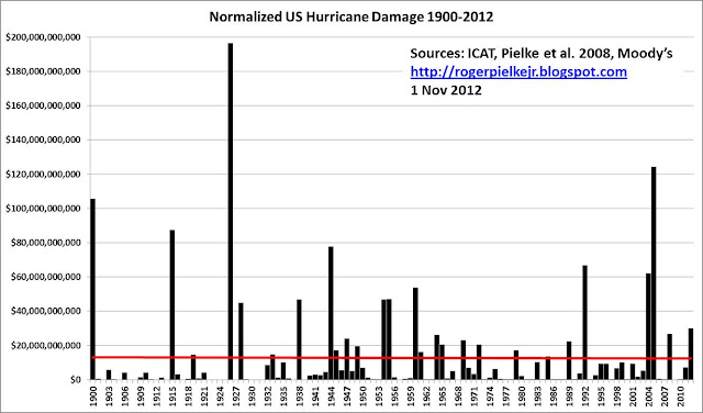 The graph above shows normalized US hurricane damage, based on data from ICAT, which applies an extension to the methodology of Pielke et al. 2008. The 2012 estimate for Sandy comes from Moody's, and is an estimate. The red line represents a linear best fit to the data -- it is flat. The graph above shows normalized US hurricane damage, based on data from ICAT, which applies an extension to the methodology of Pielke et al. 2008. The 2012 estimate for Sandy comes from Moody's, and is an estimate. The red line represents a linear best fit to the data -- it is flat. Cyclones are nothing new in Oz:  |
|
|
|
Post by graywolf on Oct 6, 2016 22:00:03 GMT
Can we just witness this as an extreme, life threatening, weather event and cut the 'point scoring' pro/con 1.2c warmer/5% more capacity to carry moisture? this whole thing is driven by Mother N. ,and the hand She was dealt. It looks as though a final ( before land fall/scrape) Eye Wall Replacement cycle (EWR) is ongoing? Two schools of thought there; 1/ EWR will not complete and leave a weaker, 75 mile wide, eye wall to impact Florida. 2/ The Gulf stream intensifies Matthew speeding up EWR in time for land fall. The trochoidal wobbles of the inner ( 12 mile) eye around the interior of the ( 75 mile) outer eye leads me to favour 2! www.sfwmd.gov/portal/page/portal/xweb%20weather/current%20weather%20conditions%20(radar) |
|
|
|
Post by nautonnier on Oct 6, 2016 22:56:51 GMT
The most recent 'projection' is that the strength will drop early Saturday probably with an eyewall replacement. This is good news if it happens as the most populous part of Florida is the I-4 corridor from Daytona through Orlando to Tampa. _IF_ my power stays up I will be able to provide a first hand account. In this sub-division (housing estate) there are all variants from full steel shuttering on every door and window through plywood panels to nothing apparently done at all.
Its rather like 3 little pigs and the huffing puffing wolf.
|
|
|
|
Post by graywolf on Oct 6, 2016 23:05:31 GMT
|
|
|
|
Post by sigurdur on Oct 7, 2016 1:20:05 GMT
Graywolf: There is ample Paleo evidence that indicates Matthew isn't even close to being the strongest hurricane to hot Florida.
As far as tornadoes, they have become less frequent. Thank goodness a repeat of The tri-state tornado of 1925 hasn't happened.
|
|


