|
|
Post by walnut on Apr 30, 2019 13:02:19 GMT
No, wouldn't want to live in Sydney. I did like the Gold Coast. I'm amazed to hear it is 600,000 people now. I got my shoulder dislocated by a wave at Surfer's Paradise, and couldn't throw my backpack on. I ended up having to live on the beach there for about a week while it healed. No message is showing up yet I agree completely. Nothing is boring. I'll say also, The prettiest large city that I have seen in North Sydney, especially around the inlets of the ocean. San Francisco and Los Angeles do not quite match up. I have not been to San Diego. I have seen Seattle and Vancouver. [ Snip ] Sydney Harbour is spectacular but would you want to live in Sydney? Traffic chaos, real estate prices astronomical, crime, homelessness, poverty, etc. Just like all big cities. It's plenty bad enough here on the Gold Coast with only 600,000. Check your messages. |
|
|
|
Post by missouriboy on Apr 30, 2019 13:13:46 GMT
Drive for miles and miles and miles ... then ...   Seismic or erosion? Bounded by highly deformed mountain ranges both east and west, the Colorado Plateau rose as a relatively flat block to elevations of over 5000 feet. Water is believed to have done the rest ... often channeled along fracture systems in the block. The south flank of the plateau is bounded by a large block fault (the Mongollan Rim) whose edges rise to 7000 feet (just south of Flagstaff, AZ). See pinched photo. Behold and marvel ye pitiful little climate "scientists". The Colorado Plateau - Photos on Colorado River just east of Kanab Utah (and north of the Grand Canyon). 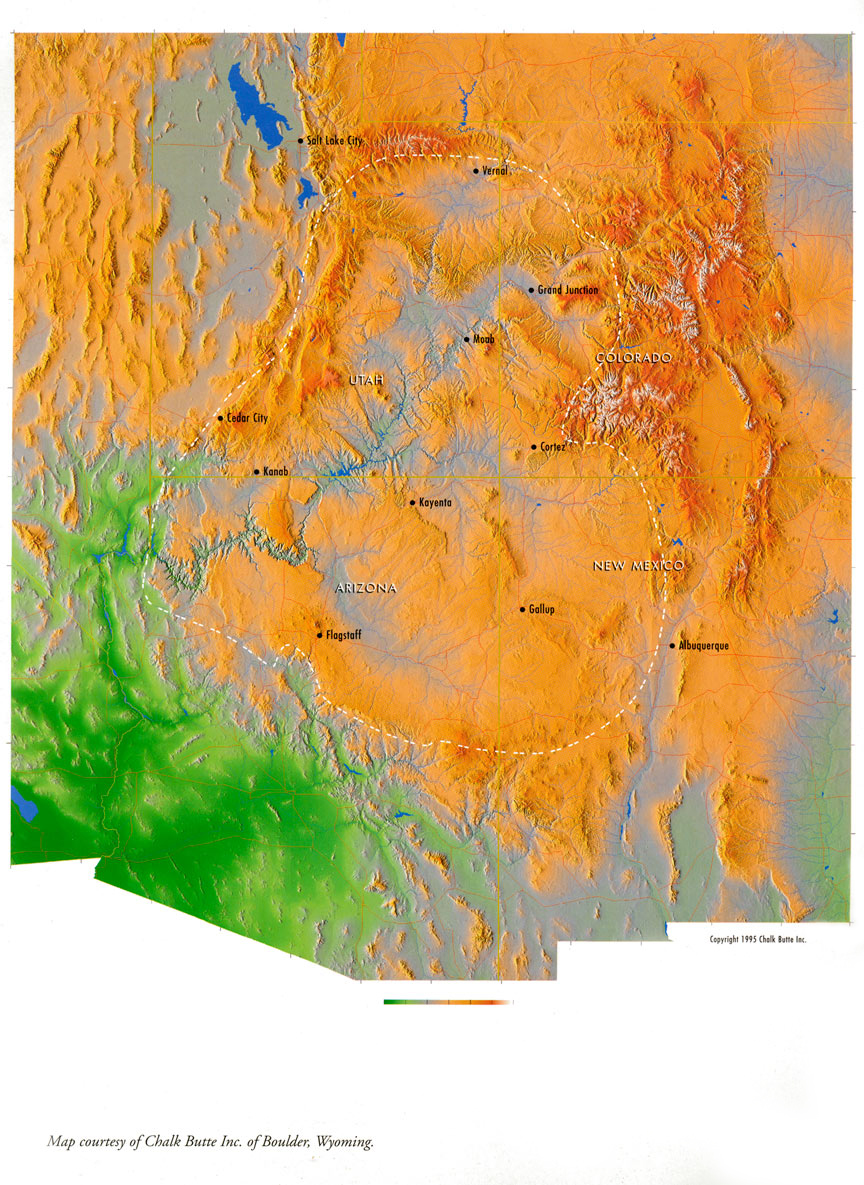  |
|
|
|
Post by walnut on Apr 30, 2019 13:35:25 GMT
I like how the granite walls of the Rockies jut up abruptly from the high plains on the east side.
|
|
|
|
Post by missouriboy on Apr 30, 2019 13:42:51 GMT
I like how the granite walls of the Rockies jut up abruptly from the high plains on the east side. And it is all "settled science" and it is OUR fault. Logic in the age of Mann. |
|
|
|
Post by walnut on Apr 30, 2019 13:45:58 GMT
Read a Scientific American or a National Geographic from 80 years ago and you won't get that dose of human blaming. It is quite a contrast.
|
|
|
|
Post by Ratty on Apr 30, 2019 13:59:34 GMT
[ Snip ] If you had said that photo was taken in the Blue Mountains, West of Sydney, I would have believed you.  |
|
|
|
Post by missouriboy on Apr 30, 2019 14:18:31 GMT
Water just keeps on coming. Fortunately I got the lawn mowed while it was still shorter than the lawn mower. Buku hay this year.
|
|
|
|
Post by missouriboy on Apr 30, 2019 14:20:49 GMT
[ Snip ] If you had said that photo was taken in the Blue Mountains, West of Sydney, I would have believed you. Substitute eucalyptus and I would too.  |
|
|
|
Post by walnut on Apr 30, 2019 14:22:13 GMT
For us, it is another day of 1 -2 " of rain expected, they even issued a flash flood watch. So far we have had a sprinkle, and I don't see anything imminent on the radar. Water just keeps on coming. Fortunately I got the lawn mowed while it was still shorter than the lawn mower. Buku hay this year. |
|
|
|
Post by missouriboy on Apr 30, 2019 14:49:17 GMT
For us, it is another day of 1 -2 " of rain expected, they even issued a flash flood watch. So far we have had a sprinkle, and I don't see anything imminent on the radar. Water just keeps on coming. Fortunately I got the lawn mowed while it was still shorter than the lawn mower. Buku hay this year. Short Range Public Discussion (Latest Discussion - Issued 0729Z Apr 30, 2019) Valid 12Z Tue Apr 30 2019 - 12Z Thu May 2 2019 ...Active weather pattern continues across the Plains and the Rockies... The weather pattern will continue to be unsettled across much of the Plains and extending westward across the Rockies through the middle of the week. A quasi-stationary frontal boundary will persist from the central Rockies to the Midwest, and also extending eastward to the Mid-Atlantic region and Northeast. Multiple waves of low pressure are expected along this front and result in areas of enhanced rainfall. The heaviest rain is likely from eastern Oklahoma to central Illinois, with widespread 2 to 4
inch amounts expected. There is an increased threat of flash flooding across the central plains where multiple rounds of thunderstorms are expected, and WPC has a Moderate Risk of excessive rainfall from northeast Oklahoma to central Missouri. The threat of severe weather is also present across this same general area with intense storms likely developing in the vicinity of the front and near the surface low. Across the Rockies, heavy snow will be making headlines through Tuesday
night with the potential for 1 to 2 feet of accumulation for the higher mountain ranges. This will be enhanced by moist upslope flow on the north side of the front. Some snow is also likely across the western High Plains from western Nebraska to eastern Montana. |
|
|
|
Post by walnut on Apr 30, 2019 15:00:02 GMT
|
|
|
|
Post by Ratty on Apr 30, 2019 22:35:01 GMT
|
|
|
|
Post by missouriboy on May 1, 2019 1:35:25 GMT
Two inches today and more expected. Gotta drive one of my wife's cousins down to Fort Leonard Wood tomorrow. Hope the creeks stay in their banks. A river of rain extends all the way from Texas through eastern OK on up to NE MO. Tornado warnings on the loose in SW MO. Must be CO2. |
|
|
|
Post by blustnmtn on May 3, 2019 10:36:49 GMT
|
|
|
|
Post by missouriboy on May 6, 2019 12:36:01 GMT
|
|


