|
|
Post by alex4ever on Jun 12, 2009 9:50:03 GMT
what i saw was an absolute mammatus cloud. I must somehow report this to somewhere its significant really, whoever was a witness was astonished this cloud has never been formed here or at least not formed in the last hundreds years. I once saw it before 5 months but the bubbles did not last much and they were small, now it was like a miracle. The cloud was so dark at the begining and vast. the borders of the cloud were absolute clear and i couldnt really figure out if this was a nimbostratus or a very thick stratocumulus. Thunders were not falling that time or at least i couldnt see them. Then, while i was sitting on pc thought i saw a part of the cloud to become twisted. It was like seeing the cloud separating into thick and vast layers. I went to my balcony and i saw what i was expected to see. The layers started formating into huge bubbles that time i took my camera and took photos. Many other people saw this, looked at it for a while but they had no absolue idea what they had just witnessed. Really you dont know how significant its appearance here it is. When i given the photos to my friends, even those who made fun of me before were astonished  . If someone can contact personally with me to give me advice were to post this i would really apreciate it. |
|
|
|
Post by woodstove on Jun 12, 2009 13:02:44 GMT
Hi Alex. If you don't already have a website, you could set up a blog, without charge, on wordpress or blogger -- Google either and you'll see that it takes about an hour to set one up. Or you could put your photos on picasa or another photo service, at least some of which are also free. Once your image is in a website with a url (meaning the line of code in the narrow field at the top of your web browser), then copy the url. Start a comment here on sc24.com, type " ![]() ", paste the url, and type "[/img], and you should be all set. Other commenters here may have easier/better ways, but that is what I would do. Good luck. I look forward to seeing your photos. By the way, we two tornados come through my hometown of Austin, Texas, last night. We even spent a little time under the stairwell with our daughter and two dogs just to be safe. They passed safely several miles away from us and didn't do enormous damage even up north of us where they touched down. It was a relatively LOUD storm by local standards. ;D |
|
sol
New Member

Posts: 13
|
Post by sol on Jun 12, 2009 17:51:08 GMT
Photobucket is easy to use for setting up a photo-sharing reference site.
|
|
|
|
Post by william on Jun 12, 2009 18:11:38 GMT
Has anyone else observed Svensmark clouds? The type I saw over Calgary, Alberta, looked similar the clouds over Scotland shown in this article. The clouds were interwoven in a repeating pattern across the sky. www.dailymail.co.uk/sciencetech/article-1189877/The-cloud-Meteorologists-campaign-classify-unique-Asperatus-clouds-seen-world.htmlSvensmark clouds. Curiouser and curioser. Whipped in fantastic shapes, these clouds hang over the darkening landscape like harbingers of a mighty storm. But despite their stunning and frequent appearance, the formation has yet to be officially named. They have been seen over Britain (multiple locations), New Zealand, Canada (Calgary, Alberta), Greece, …. … but usually break-up without producing a storm. |
|
|
|
Post by woodstove on Jun 12, 2009 18:20:07 GMT
Alex: sorry the html code I type didn't appear. Try finding a photograph somewhere on this site, then press the button to quote and the appropriate code for putting an image in a post should appear, copy and paste that code into a new message and put your url between the code (which basically is open bracket img close bracket on the left and open bracket /img on the right). You'll see when you quote a message with an image in it.
|
|
|
|
Post by woodstove on Jun 12, 2009 18:23:23 GMT
Has anyone else observed Svensmark clouds? The type I saw over Calgary, Alberta, looked similar the clouds over Scotland shown in this article. The clouds were interwoven in a repeating pattern across the sky. www.dailymail.co.uk/sciencetech/article-1189877/The-cloud-Meteorologists-campaign-classify-unique-Asperatus-clouds-seen-world.htmlSvensmark clouds. Curiouser and curioser. Whipped in fantastic shapes, these clouds hang over the darkening landscape like harbingers of a mighty storm. But despite their stunning and frequent appearance, the formation has yet to be officially named. They have been seen over Britain (multiple locations), New Zealand, Canada (Calgary, Alberta), Greece, …. … but usually break-up without producing a storm. Svensmark clouds are not unusual at all. First, they are generally just stratus clouds and can form anywhere. Second, they are most widespread, and have their most important effect, over the oceans. As Svensmark and Calder write in The Chilling Stars, they are the clouds one sees during long trans-Atlantic flights, for instance. They have a name because of their mechanism rather than their appearance. |
|
|
|
Post by alex4ever on Jun 12, 2009 18:29:05 GMT
Sorry but what i meant was that i wanted to report them to some kind of research center, not publish them to internet sites. It is not in my liking to do this really:P There are many images representing Mammatus clouds on internet so it is not really a matter.
|
|
|
|
Post by bender on Jun 14, 2009 15:22:12 GMT
|
|
|
|
Post by nautonnier on Jun 14, 2009 16:51:25 GMT
Mammatus Clouds are quite well known normally seen under turbulent cumulonimbus storm clouds looking like:  The new cloud type looks like a woven shape or meshed series of lenticular clouds and the proposal is to call them 'asperatus' clouds apparently from the Latin for a rough sea. They do NOT appear to be associated with cumulonimbus and disperse without heavy rain.  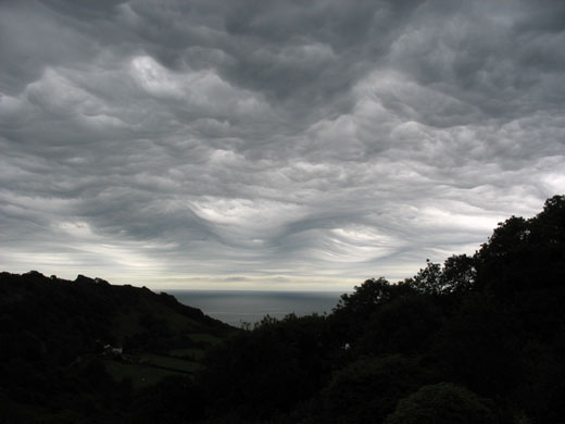  Svensmark's hypothesis was that at solar minimum with a reduced solar wind more energetic cosmic rays enter the atmosphere where they ionize particles in the troposphere by colliding with them leading to more clouds higher albedo and cooling. AFAIK there is nothing in the hypothesis defining the cloud type. |
|
|
|
Post by woodstove on Jun 14, 2009 17:11:58 GMT
[From The Chilling Stars, by Henrik Svensmark and Nigel Calder (after the horizontal line will be my own comments):]
Research in Copenhagen revealed what kinds of clouds are most important for climate change, and most influenced by the cosmic rays. They are low clouds that cover huge areas of the earth -- particularly noticeable on flights over the ocean, where they provide shiny but monotonous scenery for thousands of kilometers.
[and]
The use of different types of weather satellites from several countries, and difficulties in distinguishing clouds from icy, cold and mountainous surfaces, created imperfections and uncertainties in the satellite compilations. Svensmark elected to use only the monthly records of clouds over the ocean as seen by American, European and Japanese geostationary satellites hovering high over the Equator. From various possible sources of cosmic-ray data he selected the monthly averages of neutron counts at John Simpson's station at Climax, Colorado.
The match was striking. Between 1984 and 1987 the Sun gradually became less stormy and more cosmic rays reached the Earth. Cloudiness over the oceans increased progressively by nearly 3 per cent.
____________________________________________________________________
Again, any connection to the existence of any new cloud would be separate from what Svensmark has based his research upon. The central point of the theory is that the oceans are cooled by these very common low clouds and that cosmic rays regulate those clouds.
|
|
|
|
Post by alex4ever on Jun 14, 2009 19:46:04 GMT
No bender. My statement was clear i know all the cloud types with their subforms and their special forms. What woodstove shows is obviously the cloud ive seen. Its a Mammatus cloud. Mammatus cloud is not a species of cloud, its a special form of some species, of some types. Mammatus can be formed in high clouds : in Cirrus cloud (Ci), Cirrocumulus cloud (Cc). It can also be formed in medium clouds: in Altostratus (As) and Altocumulus (Ac). Finally it can be formed in low clouds and i guess thats the category ive seen it being structured: in Stratocumulus (Sc) and Cumulonimbus (Cb). These are the two types of cloud which Mammatus can be formed in the low ones. As i mentioned in previous post,1) i did not hear any thunder and i checked that at a thunder detector and 2) The cloud was layer-like. So we can now conclude that the cloud i saw this being created was a thick Stratocumulus cloud. Nimbostratus (Ns) cloud is also layer-like, though it also brings thunder and rain. Despite these, Ns cloud do not form Mammatus... The possibility of a mixed cloud (Cumulonimbus hidden inside of a Stratocumulus for example) is also possible. When Mammatus left, it started raining about an hour later with thunder occurances. There is a chance for the Mammatus to have been appeared in Cumulonimbus which were still in youth.
|
|
|
|
Post by bender on Jun 16, 2009 0:45:59 GMT
"June Winter Wonderland In New Jersey? Hail Storm Pounds Parts Of Garden State With Several Inches; Residents Watch In Amazement As Plows Clear Streets" wcbstv.com/local/washington.township.hail.2.1045714.html"Parts of New Jersey were pummeled by a massive hail storm on Monday afternoon, leaving it looking as if a June blizzard blew through with inches of dime-sized pellets piling up. Washington Township residents were seen on their driveways breaking out the snow shovels and officials sent out bulldozers to act as snow plows to clear the streets after severe thunderstorms pounded the region. Children were seen forming hailballs. CBS 2 HD's Christine Sloan was in Washington Township and spoke to stunned residents. This as the snow and ice piled up around them. It was a day for snow boots and a jacket as several inches fell in what's being looked at as one freak storm." |
|
|
|
Post by byz on Jun 20, 2009 7:43:27 GMT
Well no internet connection for a week, plus exams meant no condition updates.
Well June looking pretty average for the 71-2000 sequence so cooler than the average since 2001.
Mind you if you just look at the last two years it's above average!!
;D
This year so far has been bad for tomatoes due to late frosts in May, good for potatoes and Strawberries (had two bowls full so far).
And due to generally dry conditions bad for slugs (though that could be the organic slug killer working!). ;D
|
|
|
|
Post by tacoman25 on Jun 20, 2009 21:26:30 GMT
Phoenix has been below 100 for 15 straight days, unprecedented for June.
Here in Denver, we haven't been above 81 since May 20...also unprecedented for this time of year. It looks like we finally heat up in a few days, though.
|
|
|
|
Post by byz on Jun 27, 2009 20:55:14 GMT
Well it looks like we'll get a good warm week!
The warmest june days for over two years (as the last two summers were not good), should be good for the tomatoes ;D
|
|

 . If someone can contact personally with me to give me advice were to post this i would really apreciate it.