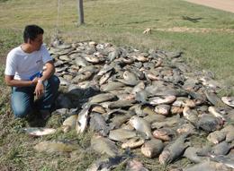
"Cold empties Bolivian rivers of fish" "The extraordinary quantity of decomposing fish flesh has polluted the waters of the Grande, Pirai and Ichilo rivers to the extent that local authorities have had to provide alternative sources of drinking water for towns along the rivers' banks. Many fishermen have lost their main source of income, having been banned from removing any more fish from populations that will probably struggle to recover.
The blame lies, at least indirectly, with a mass of Antarctic air that settled over the Southern Cone of South America for most of July. The prolonged cold snap has also been linked to the deaths of at least 550 penguins along the coasts of Brazil and thousands of cattle in Paraguay and Brazil, as well as hundreds of people in the region."
Amazing how cold it can get during the 'warmest year ever' isn't it - and as we are repeatedly told that is shown by UAH too.....
Makes you wonder if the right metric is being used.
"The rules are simple: They lie to us. We know they are lying. They know we know they are lying, but they keep lying to us and we keep pretending to believe them."
Heard on local radio (Melbourne Victoria Australia) where gardening expert stated that Spring here is running at least two weeks later than normal. Not surprising with below av July, August & cold start to September. Forecast is for more heavy rain on its way.
Post by kiwistonewall on Sept 18, 2010 8:10:34 GMT
"We've never had a snow fall this big before, in our history. We've been going ten years and unfortunately in this instant it just hasn't been able to sustain it.
Note: Engineers would have designed stadium to withstand any "likely" snowfall.
Post by kiwistonewall on Sept 22, 2010 20:27:20 GMT
What do you do when:
All your supermarkets & Malls have flat roofs not designed for snow & near failing - so closed to the public
But another snow storm is coming and the public are being advised to stock up on food?
Pity the New Zealanders
"Civil Defence controller Neil Cruickshank urged people to take stock of their ability to cope with another onslaught of bad weather, saying many had been caught out when all Invercargill's supermarkets closed yesterday." tvnz.co.nz/national-news/floods-north-snow-south-3789789
Warmer weather to come: scientists THE constant cold fronts bom barding Invercargill NZ will continue until at least the weekend but there is some good news - climate scientists are still forecasting a warmer and drier-than-average spring and summer. MetService duty forecaster Andy Downs said the province would stay in the firing line from the west to southwest fronts, similar to what had been coming through for the previous five days. Strong southwest gales were ex pected last night and they could continue today, he said. "There's not much respite and they could be even stronger (today)." The relentless fronts would bring more rain and showers, some of which would fall as snow in the hills, above 200m, and at times snow could fall at sea level. "We're not expecting for you guys to end up with another huge amount of snow in Invercargill. But in the hills in the north and in Catlins we could start to see a reasonable accumulation." The wind chill factor would be quite significant, especially for farmers in the middle of lambing. Some improvement might arrive on Saturday. Earlier this month, a The Southland Times front-page story declared the sun was coming, pointing to a La Nina cycle that should lead to a continuation of the drier-than-average conditions enjoyed during winter. Yesterday, Niwa climate scien tist Georgina Griffiths said better weather should be coming. "We haven't changed our seasonal forecast," she said. "I know you've had a very cold spell, but we are only 21 days into a 90-day period. "The forecast still stands. There are still lots of good reasons why the La Nina warmth is likely to continue. The forecast is for a season rather than a couple of weeks." The maximum afternoon tem peratures across Southland on Saturday had been the lowest on record for September - 4.1degC in Invercargill (average 12.9degC) and 5degC in Gore, Ms Griffiths said. "It was an extremely cold event ... and unusual for this time of year." The moderate La Nina system was still showing signs of intensi fying, which still should mean a good summer for Southland, she said - www.stuff.co.nz/southland-times/news/4153042/Warmer-weather-to-come-scientists
This cold weather started in July Mercury plunges to record lows
NZ Herald By Michael thingyison 4:00 AM Wednesday Jul 14, 2010 An extreme cold snap has broken temperature records and produced what are likely to be the country’s coldest nights this year. The National Institute of Water and Atmospheric Research said the past few days had seen some of the lowest temperatures on record. Air temperatures in Taumarunui, in the central North Island, dipped to -6.8C this week, the coldest since records began in 1947. Te Kuiti and Turangi had their coldest July nights on record, and in the South Island, Blenheim experienced its second-coldest July temperature yesterday morning. Queenstown, at -7.2C, had its third coldest night in 139 years of records. Even Auckland and Wellington got close to air frosts, reaching minimum temperatures of 2.4C and 1.5C this week. Hamilton recorded -3.3C and Christchurch -5.4C. Niwa climate scientist Georgina Griffiths said a deep low to the north had dragged exceptionally cold Antarctic air over the country that lingered for weeks. “The air must have been pretty cold to get to those minimum temperatures,” Ms Griffiths said. The cold air had also stayed for a remarkably long time, with Dunedin getting air frosts on each of the past 20 days. The extremes of the past week would probably make the recent frosty nights this year’s coldest, she said. Most of the coldest temperatures were recorded early on Monday. MetService forecaster Rob Kerr said the cold snap was caused by persistently clear skies and light winds. The chills
* -7.2C in Queenstown, the third-coldest night in 139 years. * -6.8C in Taumarunui, the coldest since 1947. * -5.4C in Christchurch. * -3.3C in Hamilton * 1.5C in Wellington * 2.4C in Auckland - Source: National Institute of Water and Atmospheric Research
Interesting articles. If possible could you please post the links to the articles? Thanks,