|
|
Post by missouriboy on Mar 6, 2021 0:08:35 GMT
Thanks Acid. That is interesting. I wonder if there are any timeseries data for that part of the Atlantic. Would be interesting to plot against previous Ninas. |
|
|
|
Post by missouriboy on Mar 6, 2021 0:54:29 GMT
By July-August of the 2nd Nina year, Nina for 2010-11 peaked above -0.5 C untill fall. Nina for 96-97 remained largely below -0.5 C for this period. By early autum, both Ninas were headed down to their second minimums bottoming in the Dec-Jan timeframe. The 2020-21 Nina is tracking 2010-11 fairly well in terms of strength, particularly in Region 3. Not so deep in Region 4. By early Autumn we may see declining values below neutral (if above -0.5C is neutral) if 2020-21 follows its predecesors. They may be bringing a "bull" to a "bear" fight.  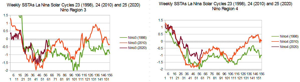 |
|
|
|
Post by missouriboy on Mar 6, 2021 19:40:55 GMT
To date I have looked at relatively long datasets of pressures for individual stations in the subtropical and northern Atlantic Ocean. Periods of low solar activity show up as reduced surface pressures, in the subtropics, and a similar decline in pressure gradients extending southward between the N Atlantic (Iceland) and 3 subtropical stations (Gibraltar, the Azores and Bermuda). These analyses seem to support the theory that reduced solar activity results in weaker Hadley cells, with declines in subtropical surface pressures. North-South pressure gradient reductions result in south-penetrating merridional flow in both winter and summer. The later has not been extensively addressed in the literature, but seems very real in terms of resulting precipitation in N Africa and the Mediterranean. I would expect that there might be similar effects in the Pacific, where reversals in the dominant Central Asian (Mongolian) pressure system (low summer - high winter) has long been known to direct atmospheric traffic flow in these areas ... commonly referred to as the summer and winter monsoons. Seems that this may be primarily a function of the extreme elevation of this area, but other factors may play a role. The Western Pacific Subtropical high may be more comparable to the strong high pressure zone of the eastern sub-tropical Atlantic ... although apparently on the west versus the east (?). Need to review this. Point being that, if low solar results in weaker Hadley cells and lower pressure in the subtropics, then this should be true in the Pacific as well. We have all noted the "huge" monsoonal rains in East Asia this year. In fact, the whole of the subtropics seem deluged this year. A rough comparison of ENSO to monsoon data suggests a general correlation of stronger monsoons with La Nina events (a westward and northward push of warm water out of the Western Warm Pool). Previous graphs seem to show a direct correlation of the PDO with ENSO. The strength of these rains this year seems out of the norm, given that the current La Nina does not appear excessive compared to the previous three. Likely other factors are involved. Undoubtedly CO2 will be blamed, but we won't go there.  This is a initial literature search with no interpretation yet. www.nature.com/articles/s41467-020-16631-9agupubs.onlinelibrary.wiley.com/doi/full/10.1002/2013JD021394 This one has some interesting analysis of eastward and westward shifts in the tropical Pacific that change between 1948-80 (colder period - low solar) and 1981-2012 (warmer period -high solar). Correlation map between interannual variation of SST and the WNPSH index in JA during the period of (a) 1948–1980 and (b) 1981–2012.  TO BE CONTINUED |
|
|
|
Post by missouriboy on Mar 10, 2021 3:32:49 GMT
Monthly ENSO Region Surface Temperatures have been released for February, 2021. Regions 3 and 4 are plotted for La Ninas beginning in January, 1998, 2010 and 2020 below. The weekly rough edges are smoother in the monthly version. EDIT 3/10/21 - Went back to Astro's forecast for ENSO dates ... Again, there will be no real El Nino until 2019 which will last into 2020.
Moreover, then a La Nina will arrive in 2021 that will extend into the first half of solar year 2022 will set new worldwide weather records under the climate regime of global cooling.Now Note chart below starts in January 2020 for La Nina 2020 beginning in early summer, peaking (max depth) in winter spanning 2020-21 (months 9-14). Just like the previous 2 La Ninas. Both two previous Ninas complete two cycles peaking (max depth) in winter and slacking in summer. The 1996 Nina completes three cycles. The current Nina has a first cycle peak (max depth) in winter 2020-21, and is now heading toward whatever summer slacking will occur. The 2nd cycle peak (max depth) should occur in winter 2021-22 (somewhere in months 21-28). Astro's forecast is obviously on target. We will see what depth occurs, and whether there is a smaller 3rd cycle (like Nina 1996) which would peak winter 2022-23. If it is more like Nina 2010, there will be no 3rd cycle. Summer 2021 slacking level and 2021-22 winter max depth still to be seen. Any indication that the "professional" agencies called this at any time with determination and precision? I think, not really. In all fairness, they should send Astro a grant, but I wouldn't hold my breath.  |
|
|
|
Post by missouriboy on Mar 18, 2021 18:15:33 GMT
ENSO Regions 3 and 4 plotted out to March 17, 2021. Last 6 weeks taken from Tropical Tidbits as weekly databases have still not been updated. Note that both Regions 3 and 4 have rushed to neutral territory slightly ahead of the 2010 Nina. Region 4 is very much warmer now than either of the two preceding Ninas. As per past trends, the 2nd plunge should start about August. The paint drys slowly. 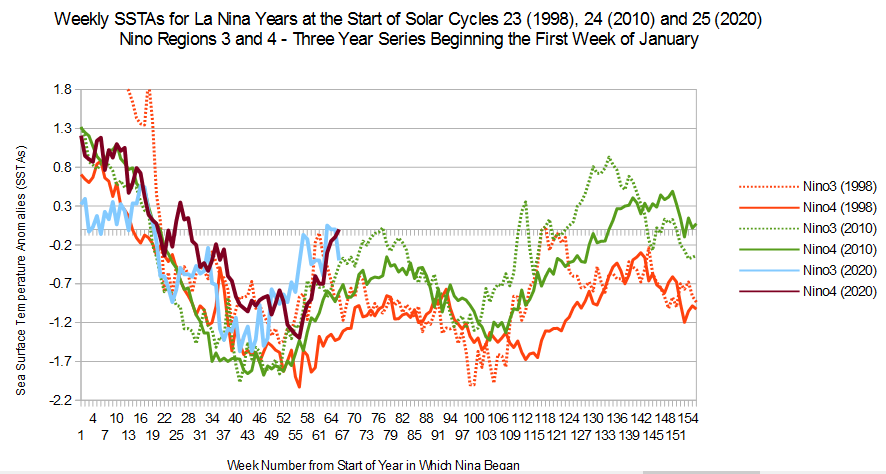 |
|
|
|
Post by nonentropic on Mar 22, 2021 5:07:45 GMT
|
|
|
|
Post by acidohm on Mar 23, 2021 18:45:00 GMT
|
|
|
|
Post by nonentropic on Mar 25, 2021 18:42:45 GMT
|
|
|
|
Post by nonentropic on Mar 25, 2021 18:49:45 GMT
The very stable rotation at the 10hPa around each pole is the norm.
The North Pole looks to be divided into two and the consequent temperature gradient is growing, it could decay and return to business as usual.
The South Pole has been beautifully stable of late but has recently developed a new wobble only a watching brief currently.
Very much in keeping with a less stable atmosphere, maybe further evidence.
|
|
|
|
Post by acidohm on Mar 25, 2021 21:55:59 GMT
The very stable rotation at the 10hPa around each pole is the norm. The North Pole looks to be divided into two and the consequent temperature gradient is growing, it could decay and return to business as usual. The South Pole has been beautifully stable of late but has recently developed a new wobble only a watching brief currently. Very much in keeping with a less stable atmosphere, maybe further evidence. Well we'll see Non!! I have several strat PhD types on my twitter feed, discusses have revolved around lack of final warming rather then it happening.... However, as I posted elsewhere, atmosphere is a little topsy-turvy down in trop soon possibly. The atmosphere is a bit unbalanced certainly. |
|
|
|
Post by nonentropic on Mar 26, 2021 1:32:40 GMT
I defer to more knowledge absolutely but I have found in the past that it gets past you and wam it's there.
|
|
|
|
Post by Ratty on Mar 26, 2021 23:49:25 GMT
ENSO Regions 3 and 4 plotted out to March 17, 2021. Last 6 weeks taken from Tropical Tidbits as weekly databases have still not been updated. Note that both Regions 3 and 4 have rushed to neutral territory slightly ahead of the 2010 Nina. Region 4 is very much warmer now than either of the two preceding Ninas. As per past trends, the 2nd plunge should start about August. The paint drys slowly. Perhaps the plunge has already begun?  |
|
|
|
Post by acidohm on Mar 27, 2021 7:15:45 GMT
ENSO Regions 3 and 4 plotted out to March 17, 2021. Last 6 weeks taken from Tropical Tidbits as weekly databases have still not been updated. Note that both Regions 3 and 4 have rushed to neutral territory slightly ahead of the 2010 Nina. Region 4 is very much warmer now than either of the two preceding Ninas. As per past trends, the 2nd plunge should start about August. The paint drys slowly. Perhaps the plunge has already begun? Ooh...... That's a good spot and very interesting Ratty!! |
|
|
|
Post by missouriboy on Mar 27, 2021 11:56:38 GMT
The very stable rotation at the 10hPa around each pole is the norm. The North Pole looks to be divided into two and the consequent temperature gradient is growing, it could decay and return to business as usual. The South Pole has been beautifully stable of late but has recently developed a new wobble only a watching brief currently. Very much in keeping with a less stable atmosphere, maybe further evidence. Well we'll see Non!! I have several strat PhD types on my twitter feed, discusses have revolved around lack of final warming rather then it happening.... However, as I posted elsewhere, atmosphere is a little topsy-turvy down in trop soon possibly. The atmosphere is a bit unbalanced certainly. The term "final warming" has an ominus tone to it. I will charitably assume this is a technical term. |
|
|
|
Post by acidohm on Mar 27, 2021 13:02:14 GMT
Well we'll see Non!! I have several strat PhD types on my twitter feed, discusses have revolved around lack of final warming rather then it happening.... However, as I posted elsewhere, atmosphere is a little topsy-turvy down in trop soon possibly. The atmosphere is a bit unbalanced certainly. The term "final warming" has an ominus tone to it. I will charitably assume this is a technical term. Yes 🤣 Often as we approach spring, the larger temp gradient that drives the strat vortex in winter slacks of, the vortex destabilises which results in a compression/warming event. After that the vortex would be in its summer phase. |
|


