|
|
Post by nautonnier on Mar 6, 2020 22:59:51 GMT
|
|
|
|
Post by nonentropic on Mar 25, 2020 3:33:07 GMT
Hes not wrong yet lets see but agree its sticking. SOI is neutral ish and going no where. Early days..
|
|
|
|
Post by missouriboy on Mar 25, 2020 3:53:55 GMT
In all cases in our 70 year time series, a new solar cycle is always preceded by a combination of El Nino followed by La Nina. We have had our small pre-cycle El Nino. La Ninas set in as the new cycle is taking off. When will that new cycle take off? Based on past experience, I would forecast a La Nina close on the heels of that launch. Astro has forecast a big one ... and a Mama Mia Winter of 2021-22.  We will see. 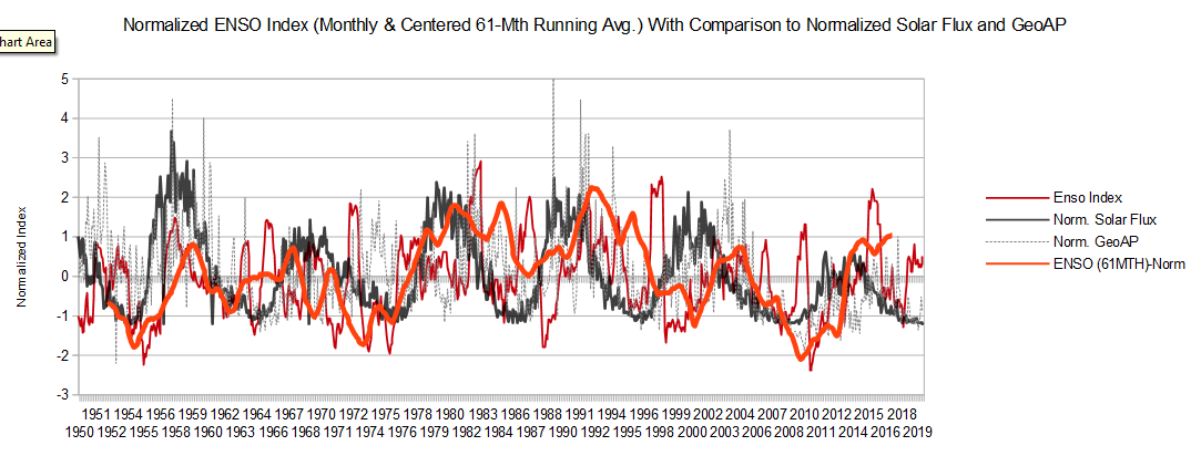 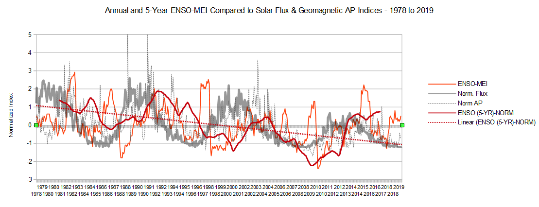 |
|
|
|
Post by Ratty on Mar 25, 2020 6:50:14 GMT
|
|
|
|
Post by nautonnier on Mar 27, 2020 19:29:07 GMT
|
|
|
|
Post by Ratty on Apr 11, 2020 22:31:00 GMT
Where else would I post this ... matching Pacific blobs: 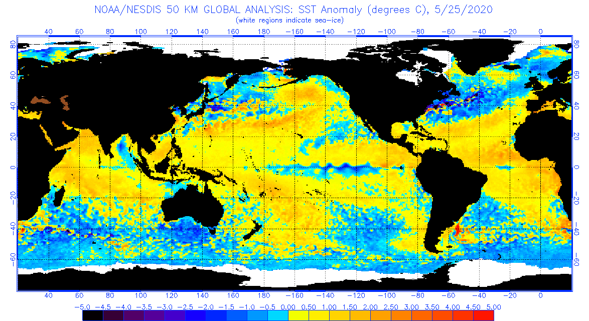 |
|
|
|
Post by missouriboy on Apr 17, 2020 12:26:29 GMT
Gav is talking Nina. A two-year Nina would take us through that terrible, awful, horrendous winter of 2021-22.
|
|
|
|
Post by Ratty on Apr 17, 2020 12:53:09 GMT
Gav is talking Nina. A two-year Nina would take us through that terrible, awful, horrendous winter of 2021-22. Like glass coffins .... remains to be seen. |
|
|
|
Post by missouriboy on Apr 17, 2020 15:57:03 GMT
Gav is talking Nina. A two-year Nina would take us through that terrible, awful, horrendous winter of 2021-22. Like glass coffins .... remains to be seen. And like glass coffins, the end is not in doubt ... merely the timing.  |
|
|
|
Post by missouriboy on Apr 27, 2020 17:15:45 GMT
Latest Monthly ENSO, Flux and UAH Temperature Anomalies through March, 2020. UAH Global and Tropical temperature anomalies follow ENSO. ENSO trends follow solar cycles. Pre-Cycle El Ninos occur before new solar cycle kicks in. El Ninos drop precipitously into following La Ninas. The last two pre-cycle Nino-following Ninas have lasted 3 years. Expect sharp changes. When? From May to July of 1998 the ENSO index dropped 3.7 points (+2.3 to -1.4). From March to July of 2010 the ENSO index dropped 3.7 points (+1.3 to -2.4). 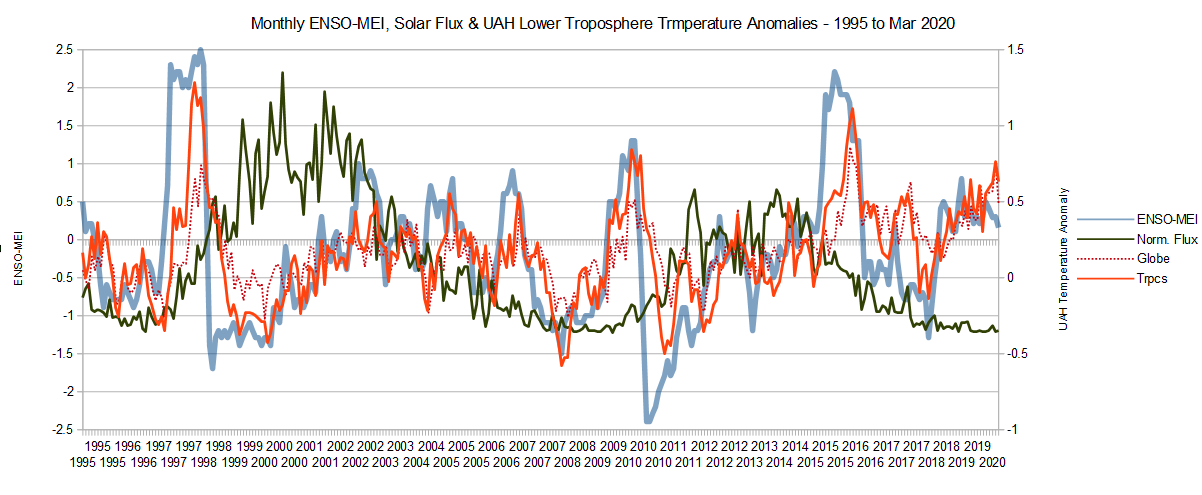 |
|
|
|
Post by nonentropic on Apr 27, 2020 20:48:49 GMT
Missouri not sure if this is possible on the global temperature data available now but Ill ask if this is possible to achieve.
looking at the global temperature it seems that a warm or cold Antarctic/arctic has a much higher weighting than is due for each hemisphere.
and the reverse for the tropics. The mid latitudes are a wash of warm cold warm cold etc as you go round the globe but the extreme moves of the the cold regions is really a symptom of a very dry atmosphere and pushes the world and hemisphere averages around without any real trend picture.
Smoothing is weak often because it hides a current change by washing it in historical data. adjusting for the enthalpy in essence is different.
not a clear question but expect you have had worse.
|
|
|
|
Post by duwayne on Apr 28, 2020 2:07:11 GMT
Latest Monthly ENSO, Flux and UAH Temperature Anomalies through March, 2020. UAH Global and Tropical temperature anomalies follow ENSO. ENSO trends follow solar cycles. Pre-Cycle El Ninos occur before new solar cycle kicks in. El Ninos drop precipitously into following La Ninas. The last two pre-cycle Nino-following Ninas have lasted 3 years. Expect sharp changes. When? From May to July of 1998 the ENSO index dropped 3.7 points (+2.3 to -1.4). From March to July of 2010 the ENSO index dropped 3.7 points (+1.3 to -2.4).  Missouri, are you predicting a super La Nina later this year? Ant(hony) predicted a strong La Nina last year and that didn't work out. He hasn't been back since then. I see the government gurus are looking for a La Nina this year. There was an El Nino coming into this year, but it was pretty weak. I wonder if next year isn't a better possibility, but that would require a strong El Nino later this year to fit the pattern. A La Nina next year would still fit with the 11-year cycle concept. I don't feel strongly enough on this to make a prediction. I would like to see a super La Nina this year since another year of high temperatures in going to negatively affect my long term temperature prediction. |
|
|
|
Post by acidohm on Apr 28, 2020 6:08:41 GMT
|
|
|
|
Post by duwayne on Apr 28, 2020 16:15:05 GMT
This animated chart is just beginning to show signs of a counterclockwise ocean rotation in the ENSO region which could lead to surface cooling and La Nina if it continues. What's needed, as most know, is an increase in east to west winds which would bring cool water to the surface in the east and blow the cool surface water across the ENSO region.  |
|
|
|
Post by missouriboy on Apr 29, 2020 3:46:24 GMT
Latest Monthly ENSO, Flux and UAH Temperature Anomalies through March, 2020. UAH Global and Tropical temperature anomalies follow ENSO. ENSO trends follow solar cycles. Pre-Cycle El Ninos occur before new solar cycle kicks in. El Ninos drop precipitously into following La Ninas. The last two pre-cycle Nino-following Ninas have lasted 3 years. Expect sharp changes. When? From May to July of 1998 the ENSO index dropped 3.7 points (+2.3 to -1.4). From March to July of 2010 the ENSO index dropped 3.7 points (+1.3 to -2.4).  Missouri, are you predicting a super La Nina later this year? Ant(hony) predicted a strong La Nina last year and that didn't work out. He hasn't been back since then. I see the government gurus are looking for a La Nina this year. There was an El Nino coming into this year, but it was pretty weak. I wonder if next year isn't a better possibility, but that would require a strong El Nino later this year to fit the pattern. A La Nina next year would still fit with the 11-year cycle concept. I don't feel strongly enough on this to make a prediction. I would like to see a super La Nina this year since another year of high temperatures in going to negatively affect my long term temperature prediction. One could theoretically start any time in the next year. As of March, SC24 was exactly as long as SC12 and SC20 (136 months - 11 yrs 4 mths) but as yet shows no immediate start of a takeoff into SC25. Pre-cycle El Ninos usually take off as or after the solar cycle starts. SC23's started 10 months after the official start month. SC24's was 8 months after. We will not know the official start date of SC25 for some time yet ... but there is no obvious flux increase yet. The SC 25 pre-cycle El Nino, if you want to call it that (3 consecutive mths over 0.5 C not met) began in Feb. 2019, and "the bump" lasted 11 mths through Dec. SC23's El Nino lasted 13 mths. SC24's lasted 10 months. So we will see. Either we get a Nina this year ... or next year. The depth and length may really depend on the strength of SC25. We have little data, but SC20 had a large preceding Nino and a moderate Nina. SC21 was much larger, and had a small Nino-Nina combo. SC's 22, 23 and 24 all show a pre-cycle spread of about 3.5 C from Nino peak to Nina trough ... and that has been consistently downward. IF that peak to trough spread is maintained, this one could definitely be cold ... or not. If it is similar to pre-SC24, the tropical UAH temperature drop was 1.25 C, which would put the 2020 or 2021 temp back to 2010 ... and who knows how long it lasts. The SC23 Nina lasted 36 mths. The SC24 Nina lasted 22 mths. That would sure sober up some warmies.  |
|