|
|
Post by blustnmtn on Feb 4, 2018 12:56:47 GMT
It may have been dug up - but I see that my graphic further up has been auto-updating Imagine the hyperbole from all the climate alarmists if that cold anomaly in the 'Nino' areas and in the matching area of the mid-Atlantic had been warm instead of cold. It is like the entire equator is going colder apart from a small stretch toward Indonesia. The only hot-spot is the stub of the Gulf Stream but you can see that its origin around Florida is colder too. Why has nobody commented on this? Current state:  JANUARY 2011 was similar but had reached its greatest visual extent (but peak of -1.9 was in Sept. 2010). Smaller El Nino than 1997 but larger La Nina. How far will this one go?  MARCH 2000 (the first image in the archive) was the peak (-1.32) of the 1999-2000 La Nina.  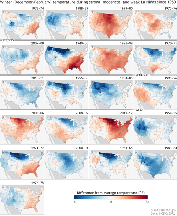 www.climate.gov/news-features/blogs/enso/january-2018-la-ni%C3%B1a-update-summiting-peak www.climate.gov/news-features/blogs/enso/january-2018-la-ni%C3%B1a-update-summiting-peakThe change in the color scale between the new graphic and the old graphics for SST is interesting. |
|
|
|
Post by duwayne on Feb 5, 2018 19:56:43 GMT
You really dug that one up. Code, what am I to take away from this comment? |
|
|
|
Post by nonentropic on Feb 5, 2018 20:52:30 GMT
We tend to look at the El Nino La Nina patterns as drivers when in fact they are more likely symptoms of some other process. As such that other process may have several states rather than just two as we have bundled it.
There will be a lot learning to come me thinks.
|
|
|
|
Post by missouriboy on Feb 7, 2018 22:24:21 GMT
We tend to look at the El Nino La Nina patterns as drivers when in fact they are more likely symptoms of some other process. As such that other process may have several states rather than just two as we have bundled it. There will be a lot learning to come me thinks.
In the N Pacific, deviations at 0-100 meters in all Latitude zones have been declining since the 2016 peak (Chart 1) After taking a vacation in 2014 and 2015, the negative PDO is back. East Pacific deviations north of 45N have dropped 0.8C since 2015 (Chart 2). Have we seen effects on West Coast and Upper Mid-West temperatures? Northwest Pacific temperatures are also going down. The Western Warm Pool is slightly above pre-2015 levels (Chart 2). In the North Atlantic, tropical-subtropical deviations are holding at about 0C. North of 45N the large decline from 2014 to 2016 is moderating (Chart 1). The large upward movement across all zones in 2010-11 and 2017 may be the warm lunar-associated pulses that David Dilly refers to in the video I posted. www.youtube.com/watch?v=iUlZ_IhEG_4 The very warm (+1C) slug of water that had parked itself along the NE US coastline has dissipated (Chart 3).  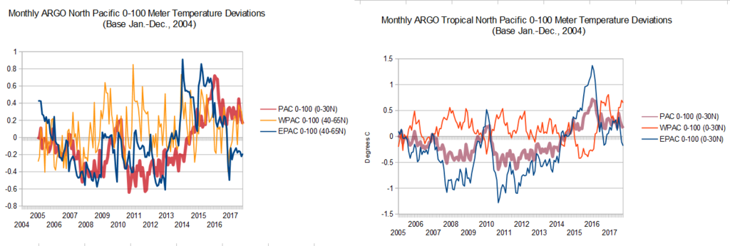 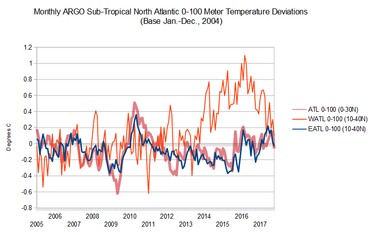 |
|
|
|
Post by acidohm on Feb 7, 2018 22:53:38 GMT
We tend to look at the El Nino La Nina patterns as drivers when in fact they are more likely symptoms of some other process. As such that other process may have several states rather than just two as we have bundled it. There will be a lot learning to come me thinks. Latest ARGO Ocean Data Bit of a mixed bag isn't it?? Atlantic seems warmer generally, pacific just stable after nino boosted temps... |
|
|
|
Post by missouriboy on Feb 7, 2018 23:11:39 GMT
Bit of a mixed bag isn't it?? Atlantic seems warmer generally, pacific just stable after nino boosted temps... The Pacific is dropping like a stone. If we get another eastward pulse of warm water it won't be as warm and it will be shorter. Small downward steps as the pacific heat continues to be shed. If Dilly is right about those pulses in the Atlantic, this one will be lower, and may decline quickly. Welcome to the 2020-22 jungle.  Don't think we are going to as much of a warm up if UV is seriously declining. Perhaps Al could make a delivery. |
|


 Don't think we are going to as much of a warm up if UV is seriously declining. Perhaps Al could make a delivery.