|
|
Post by icefisher on May 1, 2013 15:18:44 GMT
Looks like ENSO neutral for the rest of the year 2013 is the prediction of choice. 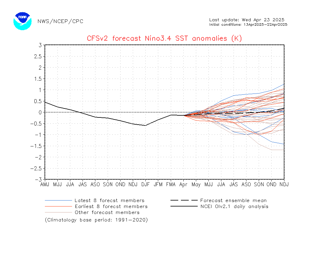 CPC-IRI server appears to be down so a plot is not available, but this also reflects ENSO neutral for rest of year. |
|
|
|
Post by dontgetoutmuch on May 1, 2013 16:07:24 GMT
I would say that more then anything, the models are reflecting "confusion" about what will happen next. If you watch that graph every three days or so, the "Latest 8" forecast differs fairly widely from the "Earliest 8", even though they are the same models, the output differs widely. In three days or so, the blue lines above will turn red, and the red lines will turn blue, and not much else will change. This is because the models seem to need momentum to work with, and right now nothing much is happening. Once the season gets well into
Fall, (Southern Hemisphere) we will see... Until then I have to agree, more La Nada...
|
|
|
|
Post by nautonnier on May 7, 2013 22:55:16 GMT
Looks like ENSO neutral for the rest of the year 2013 is the prediction of choice. CPC-IRI server appears to be down so a plot is not available, but this also reflects ENSO neutral for rest of year. Well the models may try to push for ENSO neutral but then they are based on pressures from the Nino 3.4 boxes and programmed to expect warming. If we look at the actual ocean SST anomalies though in the past this would not have been considered neutral with the large tongue of cold water stretching out from Peru. But then the modeling may be fooled by the large amount of cold to the North.  The normal pattern for a La Nina is also that the Indian ocean is warm and the currents around Japan are also warm - this year they are not. There was some discussion about the Gulf Stream (North Atlantic Drift) well the source of the Gulf Stream the Gulf of Mexico loop current is really cold as is the coast of Florida (sea temperatures barely making 76F really chill  ) Looks like Harold Ambler is right - don't sell your coat. |
|
|
|
Post by AstroMet on May 8, 2013 1:41:37 GMT
Again, according to my long-range ENSO climate outlook, there will not be another true El Nino or La Nina for many years. We won't see the next ENSO until 2021-2022. |
|
|
|
Post by icefisher on May 8, 2013 1:52:52 GMT
The normal pattern for a La Nina is also that the Indian ocean is warm and the currents around Japan are also warm - this year they are not. There was some discussion about the Gulf Stream (North Atlantic Drift) well the source of the Gulf Stream the Gulf of Mexico loop current is really cold as is the coast of Florida (sea temperatures barely making 76F really chill ) Looks like Harold Ambler is right - don't sell your coat. We may be approaching that cooling drop off. Fact is ENSO modeling is completely screwed. First, most of the dynamic models have been heavily influenced by climate models which appear well on the way to making like an aircraft drilling a well. Then there are the statistical models heavily influenced by 30 years of warming climate in a positive PDO. The final fact is all the models as a group or as a subgroup "statistical" or "dynamical" have had absolutely dismal records of predicting anything at all now for about 6 years. So I am thinking anything goes. |
|
|
|
Post by graywolf on May 8, 2013 10:45:17 GMT
After last years 'die off' of the growing Nino I'm ready to expect the unexpected! Should circulation patterns (and winds) again take a hit from Arctic melt levels I think we might do well to listen to Astro and strike the old ENSO of the grid whilst we await it's replacement?
We must have taken a lot of ocean warming over the Nina/Nada phases this past ten years though? If Enso was a battery it'd be well charged by now surely?
|
|
|
|
Post by nautonnier on May 9, 2013 15:47:10 GMT
After last years 'die off' of the growing Nino I'm ready to expect the unexpected! Should circulation patterns (and winds) again take a hit from Arctic melt levels I think we might do well to listen to Astro and strike the old ENSO of the grid whilst we await it's replacement? We must have taken a lot of ocean warming over the Nina/Nada phases this past ten years though? If Enso was a battery it'd be well charged by now surely? Its not just the sea - it is the cloudiness over the sea. The looping jet streams are carrying clouds over the ocean and the albedo is up so the oceans are not warming as much without sunlight. Clouds are the reason for the cold waters around Florida and the North Gulf coast. Those waters are meant to be the source of the heat in the Gulf Stream. Fronts have been swinging through Florida whereas normally they would not be further South than Iowa. Another weaker one this weekend. |
|
|
|
Post by AstroMet on May 9, 2013 17:42:32 GMT
After last years 'die off' of the growing Nino I'm ready to expect the unexpected! Should circulation patterns (and winds) again take a hit from Arctic melt levels I think we might do well to listen to Astro and strike the old ENSO of the grid whilst we await it's replacement? We must have taken a lot of ocean warming over the Nina/Nada phases this past ten years though? If Enso was a battery it'd be well charged by now surely? We have awhile before the next real ENSO, and that one will feature a major La Nina. It will turn very cold by 2020, and into 2021-2022 before we see some easing of that ENSO. During these interim years, we have the anomalous cold events with the extremes of weather in-between the waning global warming regime and the coming global cooling regime. This features sometimes cooler-than-normal and/or warmer-than-normal temperatures, along with blasting storms, drought, heavy rains, and radical temperature fluxes that are common with the condition of the Sun, and the modulation of the planets relative to Earth's orbit. Expect also to see and hear of rising epidemics, pandemic threats, etc., since there is a direct correlation between climate and public health. |
|
|
|
Post by dontgetoutmuch on May 20, 2013 17:23:06 GMT
There has been a large increase in the amount of cold water upwelling from the West coast of South America. Just in the past couple of days, looks like it could be significant change from recent history... Time will tell if this is the beginning of the end of La-Nada.
|
|
|
|
Post by nautonnier on May 21, 2013 6:04:13 GMT
There has been a large increase in the amount of cold water upwelling from the West coast of South America. Just in the past couple of days, looks like it could be significant change from recent history... Time will tell if this is the beginning of the end of La-Nada. That is not good news for those on the East Coast of the USA in the Hurricane Season. A La Nina would result in less windshear over the Caribbean and mid-Atlantic allowing more storms to form. The atmosphere is already quite unstable as shown by the OKC tornadoes and more locally here with an early start to the 'rainy season' in Florida - we had 5 inches of rain in 3 hours yesterday and you could see the storm cells on the radar trying to start a circulation. However, the actual SSTs are a little low for hurricane formation at the moment so nothing spun up - but the SSTs are only down by a degree.  You can see the cooler water welling up from Peru and the cooler Gulf and Florida inshore waters. ( 24-25C is a COLD sea temperature for this time of year here  ) |
|
|
|
Post by dontgetoutmuch on May 21, 2013 16:16:33 GMT
I was looking at THIS animation... |
|
|
|
Post by douglavers on May 21, 2013 22:18:21 GMT
|
|
|
|
Post by nautonnier on May 21, 2013 22:31:27 GMT
It certainly looks like a La Nina The difference is that the Kuroshio current is meant to flow past Japan made up of the displaced warm water due to the La Nina westward flow. But you can see that is cold. There is also a very strange anomaly setting up in the mid Atlantic and around NW Europe, as well as in the Gulf of Mexico and around Florida. All the wiggle watchers and that includes people looking at pressure imbalances like the SOI and MJO should be cautious as it looks like we are going into new territory with patterns that the satellite era has not seen. |
|
|
|
Post by douglavers on May 22, 2013 1:28:48 GMT
Following Nautonnier's comment, co-incidentally the satellite era pretty well encompasses the very active sun in the last quarter of the 20th Century.
If the Gulf Stream does not re-establish itself 'normally' in the next six months - whatever that means - the Europeans are going to learn the true meaning of climate change.
RIP global warming and the trillions of dollars which have been spent so far.
|
|
|
|
Post by karlox on May 22, 2013 8:11:32 GMT
Following Nautonnier's comment, co-incidentally the satellite era pretty well encompasses the very active sun in the last quarter of the 20th Century. If the Gulf Stream does not re-establish itself 'normally' in the next six months - whatever that means - the Europeans are going to learn the true meaning of climate change. RIP global warming and the trillions of dollars which have been spent so far. Look weather forecast for UK and Western Europe for coming days: still very cold, looks to me. Image for May 24 at 08:00utc: 850mb topography (round 1700m-1800m msl?)  |
|


 )
) 

 )
) 
