|
|
Post by numerouno on Jun 6, 2013 13:03:26 GMT
Amazing what such fragile thin ice will hold.... "Russians drive from Russia to Canada over North PoleMay 16, 2013 by Michel Viatteau At the "speed of a (farm) tractor" or about 10 kilometers per hour (6.2 miles/h) and carrying three tonnes of donated diesel fuel and supplies, they traveled more than 4,000 kilometers (2,485 miles) in 70 days from the Russian archipelago Severnaya Zemlya (or Earth North), after being dropped off by a Russian icebreaker, to the pole and then to Resolute Bay in Canada's far north.
Their two bright red vehicles were built around two-liter Toyota diesel engines and using old parts from prototypes that some of the team had used back in 2009 to drive from Russia to the North Pole and double back." Read more at: phys.org/news/2013-05-russians-russia-canada-north-pole.html#jCpOf course it might be that the ice is actually not as 'fragile' Or that the vehicles don't actually mind traversing on sheer water.
“These are specially designed vehicles made to travel over ice and open water with an extra light aluminum body, six tires per vehicle with low pressure intended to cause little damage to the tundra,” said Natalia Babikova, who is co-ordinating the expedition from Moscow. www.cbc.ca/news/canada/north/story/2013/04/22/north-pole-russian-trucks.html www.cbc.ca/news/canada/north/story/2013/04/22/north-pole-russian-trucks.html |
|
|
|
Post by cuttydyer on Jun 6, 2013 15:12:15 GMT
from what I see .. there is heat around the arctic but as the ice is not yet melting there is no actual heat over the arctic. but then again why would there be with a cooler sun ? but could it be the melt water from last yr has done something to the currents and as they are lower so the jet stream follows .. so a higher jet stream over land and a lower one over water .. would that not set up a wave effect ? but hey i'm just rambling .. Hi Flearider, There's quite a bit of research on solar influence of the Jet Stream (leading to Omega blocking etc...)  New Scientist, April 14, 2010 Brace yourself for more winters like the last one, northern Europe. Freezing conditions could become more likely: winter temperatures may even plummet to depths last seen at the end of the 17th century, a time known as the Little Ice Age. That's the message from a new study that identifies a compelling link between solar activity and winter temperatures in northern Europe. The research finds that low solar activity promotes the formation of giant kinks in the jet stream. These kinks can block warm westerly winds from reaching Europe, while allowing in winds from Arctic Siberia. When this happens in winter, northern Europe freezes, even though other, comparable regions of the globe may be experiencing unusually mild conditions. Mike Lockwood at the University of Reading in the UK began his investigation because these past two relatively cold British winters coincided with a lapse in the sun's activity more profound than anything seen for a century. For most of 2008-9, sunspots virtually disappeared from the sun's surface and the buffeting of Earth by the solar magnetic field dropped to record lows since measurements began, about 150 years ago. Lockwood and his colleagues took average winter temperatures from the Central England Temperature dataset, which extends back to 1659, and compared it with records of highs and lows in solar activity. They found that during years of low solar activity, winters in the UK were far more likely to be colder than average. "There is less than a 1 per cent probability that the result was obtained by chance," says Lockwood, in a paper to appear in Environmental Research Letters. Judith Lean, a solar-terrestrial physicist at the US Naval Research Laboratory in Washington DC, says the analysis is statistically robust, and reckons it forms a piece in the larger puzzle of how solar activity influences weather. Often cited by climate-change sceptics as a cause of global warming, the effects of solar cycles have largely evaded the grasp of climate modellers. Lockwood found that when he removed 20th-century warming due to industrial emissions from his models, the statistical link between solar lows and extreme winters was stronger, suggesting the phenomenon is unrelated to global warming. But the sun undeniably has a big influence on weather systems: it is, after all, the energy source that powers them. "All the little pieces are adding up into something much bigger," says Lean. "People are beginning to realise that European weather is particularly susceptible to solar activity." A study she published in 2008 found that warmer-than-average temperatures were more likely in northern Europe when solar activity is high (Geophysical Research Letters, DOI: 10.1029/2008GL034864). Lean says research like hers and Lockwood's is helping to overcome a long-standing reticence among climate scientists to tackle the influence of solar cycles on the climate and weather. A big clue to the nature of this influence may lie in work published in 2008 by David Barriopedro at the University of Lisbon, Portugal, and colleagues. They investigated so-called "blocking events" in the mid-latitude jet stream during the winters of 1955-99. The jet stream brings winds from the west, over the Atlantic, and into northern Europe. Blocking occurs when the meanders in the jet stream become so large that they double back on themselves, halting the prevailing westerly winds and allowing cold north-easterlies to take control (see diagram). Barriopedro found that when solar activity is low, the blocking events move eastwards across the Atlantic towards Europe, effectively opening an atmospheric corridor to the frigid Siberian Arctic. But how can solar variability influence the jet stream? One finger of suspicion is pointing at the stratosphere, the layer of the atmosphere that lies 20 to 50 kilometres above our heads. There, patterns of winds and temperature are known to be influenced by solar activity, says Lockwood. This is because peaks in ultraviolet radiation emitted by the sun boost ozone formation in the stratosphere, which in turn absorbs more ultraviolet and heats up. The heating is greatest in the region of the stratosphere nearest to the sun and so a temperature gradient appears across the stratosphere and winds are born. How this affects the weather below is still debated. Very little is known about the physics that governs the stratosphere, but one pattern that is emerging is that stratospheric "weather" is linked to the troposphere below it - where our everyday weather and currents like the jet stream reside. Edwin Gerber of New York University studies these interactions. He and colleagues showed in 2009 that upward movements of air in the troposphere can change the patterns of stratospheric winds. These changes, in turn, can be reflected back down to the troposphere and influence weather at the surface of the Earth (Geophysical Research Letters, DOI: 10.1029/2009GL040913). "Changes in the stratospheric winds influence the path of winter storms across Europe," Gerber says. If researchers can prove that the sun can similarly induce changes in the troposphere via the stratosphere, which Gerber thinks they will, this could solve one of the biggest puzzles of the Little Ice Age - namely, that it appeared to have been a peculiarly European phenomenon, with other parts of the globe largely spared. The effects of the sun on the stratosphere are not global, says Lockwood. "They change the way the atmospheric energy is distributed around the world rather than change the total amount of energy being put into it." Future studies may show that the effects of changes in solar activity can be felt further afield, but for now it seems that Europe is particularly susceptible because it happens to sit under the northern jet stream at a longitude where its meanders can grow into kinks. Although sunspot activity is gradually returning, astronomers are not expecting it to reach its previously high levels. So if Lockwood is correct, while the general temperature trend in the northern hemisphere will increase in line with global warming over the coming decades, northern Europe can look forward to some more harsh winters. It may be time to buy some decent gloves. www.newscientist.com/article/mg20627564.800-quiet-sun-puts-europe-on-ice.html?full=trueLast years Met Office presentation "‘Top-down’ solar modulation of the North Atlantic or Arctic Oscillation" - cut & paste below link: lasp.colorado.edu/sorce/news/2012ScienceMeeting/docs/presentations/S2-01_Ineson_sorce2012.pdf |
|
|
|
Post by numerouno on Jun 6, 2013 15:30:19 GMT
Cuttydryer have noticed the word "winter" in the arcticle you posted? It is not winter at the moment.
|
|
|
|
Post by cuttydyer on Jun 6, 2013 15:44:52 GMT
Cuttydryer have noticed the word "winter" in the arcticle you posted? It is not winter at the moment. I don't follow your point, please expand... Have you read all the text & looked at the 2nd link? - Winter, Spring, Summer or Autumn makes no difference, top-down solar modulation of the AO/NAO still occurs. |
|
|
|
Post by numerouno on Jun 6, 2013 17:02:26 GMT
Cuttydryer have noticed the word "winter" in the arcticle you posted? It is not winter at the moment. I don't follow your point, please expand... Have you read all the text & looked at the 2nd link? - Winter, Spring, Summer or Autumn makes no difference, top-down solar modulation of the AO/NAO still occurs.
Lockwood and his colleagues took average winter temperatures from the Central England Temperature dataset, which extends back to 1659, and compared it with records of highs and lows in solar activity. |
|
|
|
Post by nautonnier on Jun 6, 2013 19:10:35 GMT
Nunerouno Blocking highs can occur at any time - its one of the reasons Finland is hot at the moment. In the recent past they have been more common in winter, however the meridonality of the jetstreams has increased in the last decade and this has also increased the blocking as the loops in the Rossby waves get larger. More info here en.wikipedia.org/wiki/Block_%28meteorology%29 |
|
|
|
Post by numerouno on Jun 6, 2013 20:51:04 GMT
Nunerouno Blocking highs can occur at any time - its one of the reasons Finland is hot at the moment. In the recent past they have been more common in winter, however the meridonality of the jetstreams has increased in the last decade and this has also increased the blocking as the loops in the Rossby waves get larger. More info here en.wikipedia.org/wiki/Block_%28meteorology%29I know that fact perfectly well. The study quoted above and its data and conclusions are limited to winter only. There may be another study sharing the conclusion related to the summer some day, but we will deal with it if and when it arrives. Moreover, there is a number of notable scientists that do not share that view on the reason behind the ongoing jetstream repositioning: 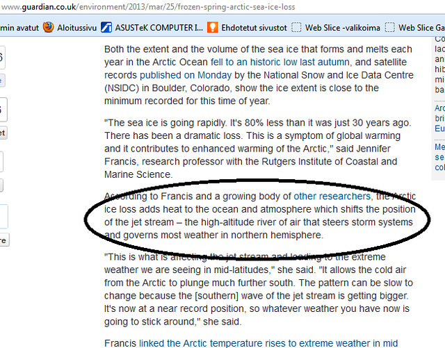 www.guardian.co.uk/environment/2013/mar/25/frozen-spring-arctic-sea-ice-loss www.guardian.co.uk/environment/2013/mar/25/frozen-spring-arctic-sea-ice-loss |
|
|
|
Post by sigurdur on Jun 7, 2013 1:51:01 GMT
The cause and effect is more convincing concerning the sun because the phenominum is also observed in the Southern Hemisphere, and there the sea ice area is growing.
|
|
|
|
Post by numerouno on Jun 7, 2013 5:19:36 GMT
The cause and effect is more convincing concerning the sun because the phenominum is also observed in the Southern Hemisphere, and there the sea ice area is growing. Sigurdur, the phenomenom observed is exactly what? That there is a global climate change? You were "uncommitted", remember? I did not see you comment on why the bird cherry constantly blooms earlier in Finland from 1846 -> ? A weird case of UHI perhaps?  www.nature.com/news/global-warming-expands-antarctic-sea-ice-1.12709 www.nature.com/news/global-warming-expands-antarctic-sea-ice-1.12709 |
|
|
|
Post by cuttydyer on Jun 7, 2013 8:31:12 GMT
I know that fact perfectly well. The study quoted above and its data and conclusions are limited to winter only. There may be another study sharing the conclusion related to the summer some day, but we will deal with it if and when it arrives. Moreover, there is a number of notable scientists that do not share that view on the reason behind the ongoing jetstream repositioning: Top-down solar modulation of the AO/NAO is not restricted to the Winter and has been known about for a long time. Here’s an extract from the 1975 publication Science News (discussing Omega blocking / meridional circulation).  high-altitude winds are broken up into irregular cells by weaker and more plentiful pressure centers, causing formation of a "meridional circulation" pattern. These small, weak cells may stagnate over vast areas for many months, bringing unseasonably cold weather on one side and unseasonably warm weather on the other. Droughts and floods become more frequent and may alternate season to season, as they did last year in India. Thus, while the hemisphere as a whole is cooler, individual areas may alternately break temperature and precipitation records at both extremes. high-altitude winds are broken up into irregular cells by weaker and more plentiful pressure centers, causing formation of a "meridional circulation" pattern. These small, weak cells may stagnate over vast areas for many months, bringing unseasonably cold weather on one side and unseasonably warm weather on the other. Droughts and floods become more frequent and may alternate season to season, as they did last year in India. Thus, while the hemisphere as a whole is cooler, individual areas may alternately break temperature and precipitation records at both extremes.Between 1962 and 1978 there was a period of low solar activity (the above article published in ’75); solar cycle 20 was stunted, with low TSI/UV output.  During the low solar amplitude periods of this time frame, the UK experience stunning extremes of weather; a few highlights: >The Winter of 1962/63 was the coldest winter of the century.
>The Winter of 1963/64 resulted in drought - this period of markedly reduced rainfall was immediately followed by a period four consecutive very WET years.
1964 (July):
1. 15minute RAINFALL of 55.9mm at Bolton, Greater Manchester: 18 July 1964. This is noteworthy, as the month overall was on the dry side, with only the northwest of Scotland and the western Isles having above average rainfall. At Dyce, for example, only 36mm/41% of RAIN was recorded. Glasgow had 45mm of RAIN, 57% of the long-period average.
1964 (Annual):
1. In the EWP series, just 725mm of RAIN, one of the DRIEST of the 20th century. The other dry years are 1921 (probably the DRIEST) at 629mm, and 1933 with 718mm.
1965-1968 (Annual series):
1. These four years all achieved over 1000 mm in the EWP series, and were thus the WETTEST period of four consecutive years since 1927-30.
1965 (1st November): FERRYBRIDGE COOLING TOWERS COLLAPSE
Three (out of 8) cooling towers at the Ferrybridge power station near Doncaster (South Yorkshire) collapsed in very strong winds, and the five remaining towers were all damaged significantly. The nearest anemometer recording (about 12km / 7.5 miles away) produced a highest (60-minute) mean wind speed of around 40 kt / 45mph, and gusts were thought to be of the order 74 kt / 85 mph at the base of the towers. These values are not of themselves excessive either generally, or for the particular location, and the problem was not so much the wind strength, but that air was forced between one group of badly-sited towers in an enhanced way to the second (leeward of the first group), causing the collapse. Pre-construction tests (using a wind tunnel) had only considered an isolated tower, not the grouping planned; neither had gusts and local eddying (particularly possible lee-wave enhancement) been allowed for. It is now considered that the gust values at the tops of the towers were some 90 kt / just over 100mph.
1966 (February):
1. One of the WETTEST Februarys across England & Wales (using the EWP series).
1966 (August):
1. Over Yorkshire, the Midlands and central southern England, RAINFALL totals were over 200% of average. By the end of the first week of the month, many places on the south coast had recorded more than their normal rainfall for the whole month. VIOLENT THUNDERSTORMS brought the month to an end on August Bank Holiday (29th). The storms did considerable damage; many main roads were FLOODED, in places to a depth of a foot or more, causing chaos to holiday traffic.
1966 (21st October): ABERFAN DISASTER
After weeks of persistent and often heavy rain, a spoil tip behind the village school in Aberfan, south Wales collapsed, burying the school under a torrent of slurry with the deaths of 144 people, 116 of the dead were school-children. After the 'East Coast' floods of 1953 (q.v.), this is now regarded as the second-worst natural disaster to affect the UK (in terms of deaths) since the Second World War.
1967 (January):
1. JANUARY: New Year's Day in 1967 was one of the COLDEST for 16 years, with many roads blocked by drifts of SNOW.
1967/1968 (October to June): MAJOR FOOT AND MOUTH OUTBREAK
1. Over 2300 farms infected - at the time the most serious outbreak in Britain. Despite stringent quarantine, the epidemic spread and it was later found that the wind was a significant vector for the disease.
1967 (December):
1. After a dry, fine (anticyclonic) first few days, as a precursor to a notably WINTRY season, an outbreak of Arctic Maritime air flowed across the country during the 6th & 7th. By the 8th, the COLD low-level air was well established. Up until the 11th, TEMPERATURES at one place or another remained below freezing point all day. (writing this in 2008, a most unusual occurrence nowadays.) In this, and another COLD SPELL (17th to 21st), NIGHT FROSTS were exceptionally SEVERE - the night of the 8th/9th was the coldest December night at Thorney Island (SE Hampshire) for 25yr. Minor disturbances (Polar Lows/Troughs) brought significant SNOWFALL for some; dislocation to transport occurred as a result of HEAVY SNOWFALLS in the northwest, and on/near the south coast of England (notably across Dorset & Sussex) on the 8th and 9th. On the 8th, 11 inches of snow (circa 27cm) lay at Brighton, with significant, but localised, transport disruption: this SNOW had fallen in only a few hours.
1968 (8th/9th January): BIG-BEN STOPS; SNOW PLOUGHS TRAPPED!
SNOWSTORM for much of the British Isles (except some NE areas & far SW). In SW England, HEAVY RAIN / WIDESPREAD FLOODING. Elsewhere, after an initial period of RAIN (or SLEET), persistent precipitation / cooling allowed the rain to turn to SNOW, and this SNOW caused chaos. Big Ben stopped for 4 hr, many villages were cut-off; roads impassable in many areas. Over a foot (circa 30cm) of SNOW fell in the Welsh border counties and conditions were made worse by STRONG WINDS (generally up to 40 knots in GUSTS) causing DRIFTING (some reports of up to 90 cm). This SNOWSTORM has gone down in the history as the storm that trapped the snow-ploughs! Three council snow-clearance lorries were trapped over the West Berkshire downs on the Wantage to Lambourn road. There was also major disruption to the London airports (then Heathrow & Gatwick), and to Birmingham - (in the early 21st century, this snowstorm would have caused near-panic! (Prichard/Weather/JMet)
1968 (15th January): CLYDE VALLEY STORM
A great STORM, possibly with TORNADIC activity, affected the Ayrshire coast and the Clyde valley. Vast DAMAGE to roofs of tenements, with around 20 people killed and around 2000 people made homeless. Gusts in excess of 100 mph (~160 km/hr or ~85 kn, not exact conversions).
1968 (February):
1. A COLD & SNOWY month. HEAVY SNOWSTORM across the Midlands (of England) on the 5th. Heavy snow fell at Keele, Staffordshire for 12 hours, giving 37cms. Crewe station was blocked. Many roads blocked, particularly in Staffordshire. Widespread disruption to traffic in Birmingham; but only a little way away, in Nottingham, the precipitation fell as rain. It was only just cold enough for SNOW (HEAVY RAIN in Nottinghamshire) so the flakes were large/heavy, with a high water content. Power cables & tree branches (some whole trees) were brought down & the NW Midlands came to a virtual stand-still. (according to RJP/'Weather').
1968 (July): NOTABLE THUNDERSTORMS, HAIL, FLOODING & COLOURED RAIN/DUST FALLS
1. On the 1st in 1968, HAILSTONES up to 7cm in diameter fell in South Wales (Cardiff-Rhoose airport). One of a series of only 10 or so 'WIDESPREAD LARGE HAIL' events recorded by TORRO. Counties affected include: Cornwall, Devon, Somerset, Glamorgan, Rhondha, Carmarthen, Shropshire, South and West Yorkshire. Other SEVERE THUNDERSTORMS in the north & west on the 1st, with DAY DARKNESS, LIGHTNING DEATHS. Also on this date, Wales & much of England experienced a significant DUST FALL / COLOURED RAIN event.
> Unusually SEVERE & prolonged STORMS on the 2nd; 35.7mm of RAIN fell in 8.5 minutes at Leeming, north Yorkshire (possibly close to a record for the short duration of the fall). FLOODING in the West Country. Also, 101mm of RAIN in 17 hr at Ronaldsway airport, Isle of Man. (See also below ... all this activity occurred as a cold front moved erratically south across the country ending a notable HOT spell.)
> More STORMS on the 8th & 9th, especially in a belt running from the southwest of Britain across to East Anglia. 175mm at Chew Stoke in Somerset, 125mm at Bristol, leading to FLOODING & DAMAGE. Worthing (Sussex), recorded 59.8mm on the 9th, which until September, 1980, was the highest daily fall in the town. Late on the 9th, a small DEPRESSION formed over NW France during the evening of the 9th, deepening markedly, bringing SEVERE THUNDERSTORMS with GALES in its wake.
> On the 10th, July, 1968, SEVERE FLOODING in Bristol/north Somerset/Cheddar region, after repetitive HEAVY RAINFALL (part of the aftermath of the stormy period 8th & 9th - see above). 175mm of RAIN fell in 24hr at Chaw Stoke (Somerset): holiday routes to the south-west became impassable. Large areas were under deep FLOOD water for several days. The village of Pensford in Somerset was one of the worst hit - as the River Chew burst its banks and the bridge over it collapsed.
> Gloucester measured 5.14inches/circa 129mm RAIN in the 24hr up to 6am on the 11th, and there was a 'notable' GALE associated with THUNDERY weather (?TORNADOES?), particularly affecting the Southend (Essex) area.
> Up to the 17th, renewed heavy rains added to the FLOODING problems.
> 31st: a THUNDERSTORM gave 75mm of RAIN at Ilford (Essex).
1968 (14th-16th September): MOLESEY FLOODS
1. Prolonged HEAVY RAIN (enhanced by some long-lived THUNDERSTORMS forming in the vicinity of an occlusion across SE England, which in turn was associated with a slow-moving depression over northern France) on the 14th, 15th and 16th in 1968 caused WIDESPREAD & SEVERE FLOODING in the south east of England with 215mm falling at Northchapel (West Sussex) within 24 hours and 57mm in 42 minutes at Purleigh (Surrey). East Molesey in SW London .. near Hampton Court Palace was particularly badly affected. More generally, much of Essex, Surrey, Kent, and London recorded 150mm (locally 200mm) over these 2 to 3 days. Tilbury, Essex recorded 201 mm in two days - more than one-third of the normal annual fall. From mid-afternoon on the 15th, FLOODING over streams and rivers built up rapidly in Surrey, causing disruption to traffic and damage to property. One person was KILLED (a man died of a heart attack as he was swept away by flood-water). The widespread FLOODING took many days to subside - the impact was primarily due to the rapid/long-lasting nature of the intense RAINFALL (convective cells) - but was perhaps most unusual in that it affected such a large area of SE England. Newspapers of the time in Kent (e.g. 'Kent Messenger') stated that it was "the worst FLOODING since 1814". The considerable / widespread FLOODING took many days to subside.Many more events during this period to view here: Link: booty.org.uk/booty.weather/climate/1950_1974.htm#1960_1969The end of cycle 20 gave the UK a two year drought and the DRIEST, SUNNIEST and WARMEST summer (June/July/August) in the 20th century - the summer of ’76. The current pattern of weather that the NH is experiencing may be remarkable within the short time frame of a life, but it is not unusual over longer periods. The UK has one of the longest temperature (CET) and historical weather records. Pick a period of low solar activity, then take a look at the CET record and the matching historical data; what do you find – extremes of cold, heat drought and floods most of which are the result of Top-down solar modulation of the AO NAO / Omega blocking /errant Jet Stream. |
|
|
|
Post by nautonnier on Jun 7, 2013 10:23:50 GMT
Nunerouno Blocking highs can occur at any time - its one of the reasons Finland is hot at the moment. In the recent past they have been more common in winter, however the meridonality of the jetstreams has increased in the last decade and this has also increased the blocking as the loops in the Rossby waves get larger. More info here en.wikipedia.org/wiki/Block_%28meteorology%29I know that fact perfectly well. The study quoted above and its data and conclusions are limited to winter only. There may be another study sharing the conclusion related to the summer some day, but we will deal with it if and when it arrives. Moreover, there is a number of notable scientists that do not share that view on the reason behind the ongoing jetstream repositioning: www.guardian.co.uk/environment/2013/mar/25/frozen-spring-arctic-sea-ice-lossTo quote that article: ' Ice loss adds heat to the ocean and the atmosphere' ..... adds heat?? The melting ice takes heat FROM the ocean - the latent heat required to melt the ice. That is why your viinas gets cold when you put ice in it - it does not get warmer. At the angle of insolation in the Arctic the sunlight is reflected off the water's surface so it is not sunlight. In the Antarctic similar equatorward movement has occurred and the Antarctic is at record ice levels so it is nothing to do with melting sea ice. Although it is possible that the looping meridonal jetstreams lead to stronger winds in the Arctic which in turn assist in breaking up and blowing the ice out of the Fram strait for example. So there could be correlation. A considerable amount of energy is involved in the polar vortex now if that energy reduces as it would if there were less strong Hadley convective cells and the associated Ferrel cells then that would allow the jet streams to move equatorward. The Hadley cells would reduce in strength if there were less solar heating at the equator. We can tell if there is less solar heating at the equator by looking at Sea Surface Temperature anomalies.  Look at the cold water along the equator from both Peru and Gabon, then North of New Zealand and even out into the Indian Ocean North West of Australia. Then where the Ferrel cells have the occasionally stationary jetstreams and cloudiness - there are more cold SSTs. There would appear to be less energy in the system generally. |
|
|
|
Post by numerouno on Jun 8, 2013 21:50:55 GMT
The melting ice takes heat FROM the ocean -
Good-ness me. And most people walk on two legs.
Consider the following. You have water and crushed ice mixed in a container. One container has 1/10 of ice and 9/10 of water. The other container has the same contents with the ratio reversed, 9/10 ice and 1/10 water. Both from the above will appear as a "healthy" layer of ice. You then apply thermal energy to both containers. Which one will clear out first? Now picture the Arctic as a grid of those containers with the ratio fo 1/10 to 9/10 containers constatly changing into the favour of the 1/10 type. What will we see?
Look at the cold water along the equator from both Peru and Gabon, then North of New Zealand and even out into the Indian Ocean North West of Australia.
The body of water that concern us Europeans most is the North Atlantic. This is directly related to the health of a huge area of Arctic ice. I can also see there is quite a swath of warm water in the Northern Pacific.
|
|
|
|
Post by numerouno on Jun 8, 2013 22:08:39 GMT
Summer watch! After a hot day of +25C the evening's thunderstorm has left water to evaporate in the cooling night. It's half an hour to the midnight hour. Taken yesterday in a Central Finland location by yours truly.  Pylons of one of the 440kV main transmission lines. A lightweight construction with guy wires. It is exactly midnight. 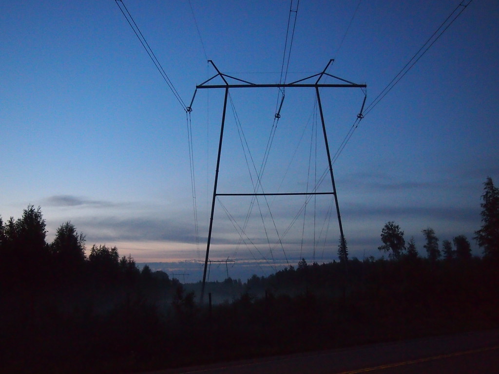 |
|
|
|
Post by flearider on Jun 9, 2013 0:01:29 GMT
The melting ice takes heat FROM the ocean -Good-ness me. And most people walk on two legs. Consider the following. You have water and crushed ice mixed in a container. One container has 1/10 of ice and 9/10 of water. The other container has the same contents with the ratio reversed, 9/10 ice and 1/10 water. Both from the above will appear as a "healthy" layer of ice. You then apply thermal energy to both containers. Which one will clear out first? Now picture the Arctic as a grid of those containers with the ratio fo 1/10 to 9/10 containers constatly changing into the favour of the 1/10 type. What will we see? Look at the cold water along the equator from both Peru and Gabon, then North of New Zealand and even out into the Indian Ocean North West of Australia.The body of water that concern us Europeans most is the North Atlantic. This is directly related to the health of a huge area of Arctic ice. I can also see there is quite a swath of warm water in the Northern Pacific. how can you say the arctic is a grid of containers ? it's nothing like that .. if there was a current going past the uk and up the coast then maybe but as you can see it's cold .. it's more like a bowl within cold water with a few bits of heat on it ..and if it does start to melt your going to get even less currents as the fresh water will stop them .. |
|
|
|
Post by numerouno on Jun 9, 2013 0:32:10 GMT
how can you say the arctic is a grid of containers ? it's nothing like that .. if there was a current going past the uk and up the coast then maybe but as you can see it's cold .. it's more like a bowl within cold water with a few bits of heat on it ..and if it does start to melt your going to get even less currents as the fresh water will stop them .. The arctic ice is not a monolith, if you mean that. It's an incredibly complex system. It's not "a few bits of heat on it" at all. If you had ever watched a considerable body of water melt, you'd understand the process better. The ice is simultaneously melting from all directions, even from the inside, but with different mechanisms. Remember, the potential insolation in the Arctic summer roughly equals that of the Equator! Where did you learn freshwater would "stop the currents"? |
|


